
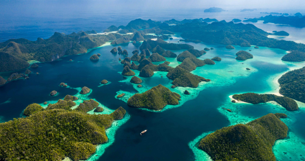
Raja Ampat is classified as the jewel of Indonesia's maritime crown for a reason that goes beyond promotional language. The archipelago contains approximately 75 percent of all known coral species on earth, spread across 640 islands, reefs, and shoals in Southwest Papua.
Every layer of this destination, from logistics to tribal geography, operates on its own logic. Understanding that logic before arrival determines whether a traveler experiences the full architecture of the place or only its most accessible perimeter.
No route to Raja Ampat is straightforward. The physical and institutional complexity of getting there is itself a filter that keeps the destination in a category separate from most Indonesian tourism nodes.
Logistics Access and Navigation from Surabaya and Jakarta
Every journey into Raja Ampat begins in Sorong. This is not a guideline, it is the structural reality of how the archipelago connects to Indonesia's aviation network.
From Jakarta's Soekarno-Hatta Airport, Garuda Indonesia, Batik Air, and Lion Air operate direct overnight flights to Sorong that depart around midnight and land at approximately 05:45 to 06:30 AM local time, with a flight duration of roughly four hours.
From Surabaya's Juanda Airport, there are no direct flights. The standard route connects through Makassar's Sultan Hasanuddin Airport before continuing to Sorong, with a total journey time of approximately six hours including transit.
Timing the flight arrival matters more in Raja Ampat than almost anywhere else in Indonesia. The public ferry from Sorong to Waisai, capital of the Raja Ampat Regency, departs twice daily at 9:00 AM and 2:00 PM from Pelabuhan Rakyat. A taxi from the airport to the harbor costs around IDR 100,000 and takes 10 to 20 minutes depending on traffic.
Missing the morning ferry creates a two to three hour dead window that compresses the entire first day. Planning departures from Jakarta or Surabaya to land in Sorong no later than 7:30 AM is the primary logistics variable that determines the quality of day one on the ground.
Main Gate: Domine Eduard Osok Airport Sorong
Domine Eduard Osok Airport, carrying IATA code SOQ, sits approximately 8 kilometers from Sorong's city center on the Bird's Head Peninsula. The airport is named after a pastor documented for missionary and educational work across the region.
It replaced the older Jefman Airport, which required a 30 to 45 minute boat crossing for passengers to reach the terminal, making access slow and operationally unreliable for any traveler with a tight onward connection.
The terminal design reflects local Papuan cultural motifs, with the exterior displaying ornamentation styled after betel nuts. Facilities inside are functional but basic: a few coffee outlets, ATMs near the exit, and a small business lounge. There is no attached airport hotel, though several properties sit within walking distance.
Collecting local currency at the ATMs on arrival is advisable because outer island homestays, speedboat operators, and marine park permit desks frequently operate on cash-only terms, and connectivity beyond Sorong drops significantly the deeper into the archipelago a traveler moves.
Direct flights to Sorong now operate from Jakarta, Makassar, Surabaya, Manado, and Bali. The Bali route, operational since late 2023, has slightly shortened the logistics chain for international travelers entering Indonesia through Ngurah Rai.
Sea Connection: Pelabuhan Rakyat to Waisai
After the airport, the next leg is entirely by sea. A short 10 to 20 minute taxi ride connects Sorong Airport to Pelabuhan Rakyat, the public harbor where all ferry traffic to Waisai originates. The public express ferry runs twice daily.
Economy class tickets run between IDR 110,000 and 137,000 per person, while VIP class with air conditioning and a private lavatory runs between IDR 250,000 and 262,000. The crossing to Waisai takes approximately two hours.
Most accommodations in the Raja Ampat Regency coordinate pickup from Waisai harbor. Sending a message to the homestay or resort when boarding in Sorong gives them enough lead time to position a boat.
Travelers arriving without a confirmed pickup can contact the Raja Ampat Homestay Information Center at Waisai for assistance. The harbor at Pelabuhan Rakyat is straightforward to navigate, and ticket counters are located inside the terminal building near the departure gate.
Fast Track Strategy Using Private Speedboat
The public ferry covers the Sorong to Waisai route only. Travelers heading to Misool, the southern zone of the archipelago, or to remote homestays far from Waisai require private speedboat transfers that operate on negotiated terms. These boats depart directly from Sorong harbor and can be arranged through accommodations in advance or through operators at the harbor on arrival.
A private speedboat to the Misool area from Sorong typically takes four to five hours depending on sea conditions and the specific destination within the island group. Costs vary significantly based on boat size, fuel load, and operator.
Booking through a resort or verified tour operator rather than negotiating directly at the dock tends to produce more reliable pricing and safety standards. The fast track strategy that makes the most logistical sense for Misool-bound travelers is to arrive in Sorong the night before, overnight in the city, and depart by private speedboat at first light the following morning to maximize daylight hours upon arrival.
Secret Places: Hidden Viewpoints Across the Archipelago
The most referenced viewpoints in Raja Ampat operate on a two-tier system. The public-facing tier includes Piaynemo and Wayag, which appear in most photography associated with the destination. The less-documented tier includes a set of elevated karst positions across Waigeo, West Waigeo, and Misool that require local boat access, a short physical climb, and no formal ticketing infrastructure.
These locations are not secret in the sense of being unknown to operators, but they are systematically absent from packaged itineraries because the boat time and terrain make them inefficient for groups.
Hidden bays along West Waigeo in particular offer the compressed karst and still-water lagoon scenery that defines the visual identity of Raja Ampat, without the queuing and vessel traffic that now characterizes the Wayag zone during peak season.
Access to these positions requires direct coordination with local homestay operators who have navigational knowledge of the specific passages between karst formations. A traveler based in West Waigeo with a trusted local guide can reach three to four significant viewpoints in a single half-day departure.
Kalibiru Warsandim: The Crystal Blue River
Kalibiru, which translates literally as blue river, is a freshwater channel in the Warsandim area of Waigeo that receives significantly less visitor traffic than the marine-focused sites dominating most Raja Ampat itineraries. The water clarity in Kalibiru is a product of limestone filtration through the karst geology underlying the island.
The blue tonal quality visible in photographs is not post-processing; it is a result of the specific mineral composition and depth of the riverbed reflecting ambient light in the 480 to 500 nanometer wavelength range.
Access to Kalibiru Warsandim requires a boat ride from the Waisai direction followed by a short walk through low vegetation. The site is manageable for most fitness levels. It is most commonly visited as part of a multi-stop day trip that combines the river with nearby villages and bay crossings.
The absence of commercial development at Kalibiru, including no food stalls, no formal entry point, and no permanent crowd management infrastructure, makes it one of the most compositionally clean natural sites in the northern zone of the archipelago.
Lenmakana Jellyfish Lake and the Misool Wonders
Lenmakana Jellyfish Lake sits on Misool Island behind a towering karst cliff that is only accessible by trekking a steep 20 to 30 minute trail through rocky terrain. The lake contains three species of Mastigias papua jellyfish that have evolved over thousands of years in a closed ecosystem without natural predators.
The stinging mechanism is vestigial, swimmers make direct contact with the jellyfish without risk of envenomation. Wearing a rash guard is still advisable for tactile comfort. The lake is among a small global set of stingless jellyfish environments, placing it in the same ecological category as Jellyfish Lake in Palau and Kakaban Lake in East Kalimantan.
Yapap, located in the same southern Misool zone, is a shallow karst lagoon with glass-clear turquoise water and vertical limestone formations on three sides. At low tide the lagoon floor becomes walkable, exposing sand and small marine invertebrates. A short viewpoint climb above the Yapap basin takes roughly five to ten minutes and produces a framing of the surrounding karst geometry that is distinct from anything available from sea level.
The Love Pool at Misool, known more formally in local navigation as Karawapop, is a heart-shaped blue lagoon visible only from a viewpoint accessed by a ten minute hike above the water. The karst mountain adjacent to the lagoon adds vertical contrast that makes the aerial framing more complex than a simple overhead image.
Indigenous Tribes of Raja Ampat: Deep Roots and Distribution
At least twelve distinct indigenous groups inhabit the Raja Ampat archipelago. These tribes are not uniformly distributed across the islands. Each major island hosts specific groups whose linguistic, cultural, and territorial boundaries do not overlap cleanly with administrative maps.
On Waigeo, the largest island, the primary indigenous groupings fall under the broad Ma'ya identity, which encompasses the Wawiyai (Wauyai), Kawe, Laganyan, and Ambel sub-groups. Each of these maintains a distinct language classified separately within the Raja Ampat language family, despite geographic proximity.
The Maya are considered the oldest indigenous presence in the region, with oral and ethnographic accounts placing their origin in the interior forests and mountains of Gulf Mayalibit. They did not inhabit coastal areas until the 19th century. Their settlement shift toward the coast was driven by trade contact and colonial-era population pressures rather than voluntary integration. On Misool Island, the Matbat tribe maintains the most intact documentation of original Papuan settlement patterns.
The Matbat villages of Magey and Aduwei are cited in anthropological literature as retaining physical and organizational characteristics consistent with pre-contact Papua. The Misool tribe, distinct from the Matbat, is predominantly Muslim and has absorbed significant cultural influence from Maluku and Sulawesi over several centuries of maritime trade contact.
Ambel, Laganyan, and Wauyai Tribes of Waigeo
The interior of Teluk Mayalibit (Mayalibit Bay) on Waigeo Island is divided between the Laganyan and Ambel tribes along a geographic axis, with Laganyan settlements occupying the western half of the bay and Ambel villages positioned from the eastern shore toward the northern coast.
The Laganyan inhabit the villages of Araway, Beo, and Lopintol and are predominantly Muslim. The Ambel occupy Kabilol, Go, Waifoi, Wairemak, Kalitoko, Warsamdin, and the northern coastal settlements of Kabare and Kapadiri, and are predominantly Christian.
These two tribes are linguistically and anthropologically distinct despite their geographic proximity. Both the Laganyan and Ambel languages are classified within the Ma'ya grouping but carry sufficient internal divergence to function as separate languages rather than dialects.
The Wauyai (Wawiyai) tribe holds customary land rights across much of South Waigeo and is among the groups whose internal place names differ completely from the Biak-derived names that appear on official maps of the archipelago.
Biak Tribe: Historical Immigrants and Cultural Reach
The Biak people of Raja Ampat are not classified as indigenous to the archipelago. Their ancestors migrated from Biak and Numfor Islands in what is now Cenderawasih Bay, Papua Province.
The historical expansion of Biak speakers into Raja Ampat was tied to their role as maritime traders and intermediaries between Raja Ampat, the Sultanate of Tidore, and Maluku. Their navigational capacity and trading networks allowed Biak-speaking settlements to establish presence across the entire archipelago, from Waigeo's northern coast to Kofiau Island in the south.
The place names currently printed on maps of Raja Ampat and used as official administrative references are predominantly Biak-language derived. This creates a documentation anomaly in which the formal geographic naming system reflects the language of historical immigrants rather than the indigenous groups with prior territorial occupation.
The Biak community on Friwen Island is a documented example of cultural displacement, where the original Wawiyai population underwent a language and identity shift toward Biak dominance over several generations of co-habitation.
Accommodation Based on Classification
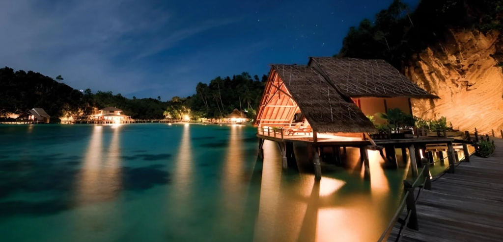
Raja Ampat's accommodation landscape divides sharply along access and budget lines. Misool Eco Resort, positioned on Batbitim Island in the southern archipelago, represents the ultra-luxury tier. It operates with a maximum capacity of 40 guests, a staff-to-guest ratio of 4 to 1, and an integrated marine conservation program that has documented a tripling of fish biomass in the surrounding no-take zone since 2007.
Water villas extend over a private lagoon, and beach villas are set into the jungle fringe. All structures are built using reclaimed hardwood and open-air Balinese-style bathrooms. This is not merely a dive resort; the conservation infrastructure includes manta ray population databases, acoustic tagging programs, and satellite-linked shark tracking participation.
Korpak Villa and Resort on Waigeo represents the boutique mid-range tier, offering structured access to northern Raja Ampat diving and snorkeling sites with a more limited bed count than mainstream dive resorts. Meridian Adventure Dive Resort in the Dampier Strait zone is the primary reference point for serious technical divers, with liveaboard coordination and structured dive scheduling across the region's most productive underwater sites.
For the authentic homestay tier, Yenros Homestay on Mansuar Island is one of the most consistently cited options for travelers seeking direct community access, local food, and morning departures to sites like Cape Kri and the Sawandarek Wall.
Prices at the homestay level in Raja Ampat are significantly higher than anywhere else in Indonesia's homestay circuit due to fuel costs, remoteness, and the marine park permit burden layered on top of accommodation costs.
Traditional Village Life and Residential Characteristics
Traditional villages in Raja Ampat are built primarily on stilts over water or at the immediate shoreline, a construction pattern driven by the karst terrain that makes interior flat ground scarce on most islands. Structures use locally sourced timber, bamboo, and sago palm thatch.
Village layouts are organized around a central communal space, typically adjacent to either a church or a mosque depending on the religious affiliation of the tribe occupying the settlement. Christian villages tend to cluster around the central highlands of Waigeo and Batanta, while Muslim villages are more concentrated on Misool and the southern Salawati coastline.
Sago is the primary carbohydrate in traditional Raja Ampat diet, processed into papeda, a starchy paste consumed with fish broth. Rice has been introduced through national food programs and is now common in mixed-diet households, but sago retains cultural primacy in village ceremonial contexts. Fishing remains the dominant livelihood, and most households maintain small outboard-powered vessels for daily subsistence movement between islands.
How to Blend in Safely and Politely
Physical access to Raja Ampat comes with a set of behavioral obligations that are more consequential here than in most Indonesian tourism destinations. The archipelago is governed partly through customary law systems specific to each tribal territory. Entering a bay, beach, or forest area without acknowledgment of local sasi rights, which are traditional conservation and access agreements managed by village elders, is treated as a serious breach of protocol.
Tour operators and homestay hosts typically manage this on behalf of guests, but travelers moving independently need to confirm access permissions before entering any area that appears uninhabited.
Photography of individuals requires direct consent and is not a casual act in most traditional villages. Dress standards in Muslim-majority villages on Misool and Salawati require covered shoulders and knees for both men and women. In Christian villages the standards are less prescriptive but still modest relative to beach resort norms.
Bringing small practical gifts, including batteries, school stationery, or basic food staples, is culturally appropriate when visiting villages where a homestay relationship exists. Arriving unannounced at a village that has not been contacted through a local operator is not advisable for any traveler without established prior contact.
The marine park permit, currently set at IDR 1,000,000 per person and valid for one year, is a non-negotiable entry requirement enforced at Waisai and other check points.
It funds the conservation infrastructure that keeps Raja Ampat's reef system in a documented state of improvement rather than decline, which is the direct reason the destination remains worth the logistical investment to reach.