
Indonesia stands as the world's largest archipelagic nation, a republic declared sovereign on August 17, 1945, built across more than 17,000 islands stretching from Sabang in the northwest tip of Sumatra to Merauke at the eastern edge of Papua. Republic of Indonesia was formally established from the ashes of colonial rule, its constitutional framework enacted just days after independence, binding together a civilization of extraordinary antiquity under one national identity.
As of 2026, based on projections from Badan Pusat Statistik, the total population of Indonesia reaches approximately 287 million people, placing the country fourth among the most populous nations on earth, behind only India, China, and the United States.

The administrative geography of about Indonesia reflects decades of regional development and governance reform.
According to data from Kemendagri updated through mid-2026, the country is organized across 38 provinces, 416 kabupaten (regencies), 98 kota (cities), 7,285 kecamatan (districts), 8,496 kelurahan (urban villages), and 75,266 desa (rural villages), forming one of the most complex subnational administrative architectures of any nation in the world.
Each layer of this structure carries distinct legal functions, fiscal responsibilities, and historical roots that predate modern statehood by centuries.
Territorial Foundations of a Nation Spanning Three Time Zones
Indonesia's administrative geography is unlike any other country's on earth, not merely because of its physical scale but because its territorial divisions evolved from pre-colonial governance systems that assigned distinct functions to each administrative layer long before Dutch cartographers drew their first maps of the archipelago.
Spanning 38 provinces across three time zones and governing over 75,000 villages through a tiered system of kabupaten, kota, kecamatan, and desa, the Republic built its national structure on top of civilizational blueprints that kingdoms like Majapahit and Srivijaya had already tested across centuries.
Geographic Divisions Rooted in Centuries of Civilization About Indonesia
Understanding about Indonesia begins with its physical and administrative layout, which is unlike any comparable country in both scale and complexity. Spanning across 5,100 kilometers from west to east and covering a land area of approximately 1.9 million square kilometers.
Indonesia occupies a zone where three tectonic plates converge, producing an island chain of volcanic mountains, tropical rainforests, and coastal plains unmatched anywhere on the planet. Geographic organization here is not merely administrative convenience but a product of how distinct civilizations developed across isolated island systems over millennia.
Provinces function as the primary tier of regional governance, each administered by an elected governor and a regional legislature. Below the provincial level, kabupaten govern rural territories while kota govern urban centers, each with their own elected heads.
Districts subdivide these further, and at the base of the structure sit desa and kelurahan, units of local governance that maintain direct contact with individual households.
What differentiates Indonesia from other large nations is that these administrative categories carry names and hierarchies inherited from pre-colonial kingdoms, where terms like desa originated in Sanskrit-influenced Javanese governance and kabupaten derived from the Javanese title bupati, the regional lord appointed by sultanates.
Unity Written Across a Thousand Dialects
Beyond its territorial divisions, about Indonesia is also a story of human diversity compressed into a single sovereign state. According to data published by BPS through the Long Form of the 2020 National Census, Indonesia recognizes more than 1,200 distinct ethnic groups and over 694 documented regional languages, making it one of the most linguistically complex nations on earth.
From the Acehnese of northern Sumatra to the Dani people of the Papua highlands, from the Bugis seafarers of Sulawesi to the Balinese performing artists of the Lesser Sundas, each community carries a living tradition that has persisted through colonization, modernization, and globalization alike.
Six religions hold official state recognition: Islam, Protestantism, Catholicism, Hinduism, Buddhism, and Confucianism. Alongside these, hundreds of local belief systems, known collectively as kepercayaan, remain active among indigenous communities across the archipelago.
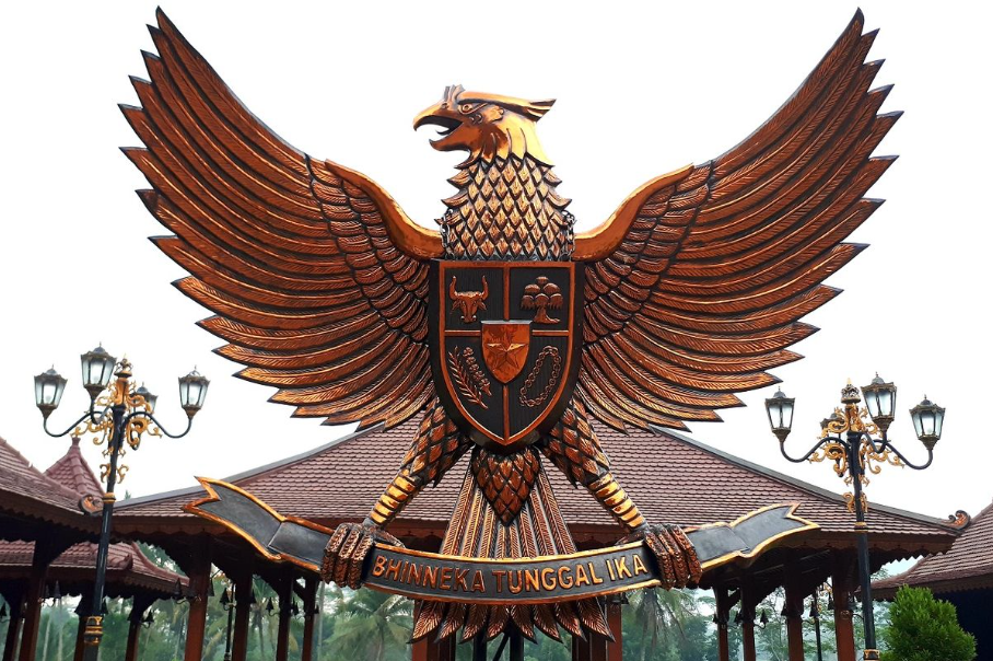
Binding every group together is the national motto inscribed on the ribbon gripped by Garuda Pancasila: "Bhinneka Tunggal Ika," drawn from Old Javanese and meaning "Different but still one."
This phrase originated in the Sutasoma manuscript, a 14th-century literary work by the poet Mpu Tantular of the Majapahit era, embedding pluralism as a civilizational value long before Indonesia existed as a modern state.
From Kingdoms to Republic: The Historical Axis of Indonesian Statehood
Indonesia did not emerge as a nation from a single founding moment but from the accumulation of civilizational pressures spanning more than a thousand years, moving through cycles of Hindu-Buddhist statecraft, Islamic consolidation, European extraction, and nationalist mobilization before arriving at the sovereign republic proclaimed on August 17, 1945.
Understanding this historical axis is foundational to understanding why Kementerian Pendidikan dan Kebudayaan frames Indonesian national identity not as a colonial inheritance but as a civilizational recovery.
Ancient Polities and the First Monotheists of the Archipelago
Long before European cartographers gave the archipelago a name, the islands of Nusantara sustained complex kingdoms operating sophisticated trade networks, legal codes, and religious institutions. Power was not centralized but distributed across dozens of polities, ranging from the Hindu-Buddhist empires of Sriwijaya and Majapahit to smaller coastal sultanates and highland tribal confederacies.
Each held sway over particular territories through a combination of military strength, ritual authority, and control over trade routes carrying pepper, cloves, nutmeg, camphor, and sandalwood outward to Arabia, India, and China.
Islam reached the western coast of Sumatra as early as 674 AD, carried by Arab and Indian merchants navigating seasonal monsoon winds across the Bay of Bengal. A notable historical marker is the account of peaceful Muslim settlers living under the tolerance of Queen Shima of the Kalingga Kingdom, with documentation of this community's existence reaching Chinese court records via the Tang Dynasty.
Hinduism and Buddhism had preceded this by several centuries, arriving through the same Indian Ocean trade corridors. Non-royal native communities, the ancestors of today's adat peoples, lived alongside these kingdoms under their own customary legal systems, many of which persist in modified forms to the present day.
The Naming of Indonesia Nation Born in the 19th Century
Ancient Greeks used the term "Indos" to denote the region around the Indus River, and when Arab sailors pushed east into the Indian Ocean they referred to the island world they encountered as "Al-Hind." Western explorers arriving from the 15th century onward called the same territory the "East Indies," a geographic designation that persisted through the early colonial period.
The word "Indonesia" itself was not coined until 1850, when British ethnologist James Richardson Logan and Scottish geographer George Samuel Windsor Earl combined the Latin "Indus" with the Greek "nesos," meaning islands, to produce a scholarly label for the archipelagic world between Asia and Australia.
"Indonesian" as an identity concept would take another seven decades to become politically charged. By the 1920s, native intellectuals educated under the Dutch Ethical Policy had adopted it as the name of a nation not yet born, using it to project a unified civilizational identity across all ethnic and religious groups of the archipelago.
By the time Soekarno and Hatta declared independence in August 1945, "Indonesia" had already been claimed as a national concept forged through decades of organizational struggle, journalistic activism, and youth mobilization. The state did not create the identity, the identity built pressure that forced the state into existence.
Nusantara as a Global Logistics Axis
Centuries before European powers claimed to have opened the world's sea lanes, Nusantara operated as the central switchboard of global maritime commerce, connecting the Indian Ocean trade system to the South China Sea through a network of ports, warehouses, and diplomatic relationships that no single outside power had built or could dismantle unilaterally.
The geographic position of the Indonesia archipelago, sitting astride every major shipping lane between Asia's two great economic poles, gave its polities a structural advantage that Kementerian Kelautan dan Perikanan today recognizes as the historical foundation of Indonesia's maritime identity.
The Monsoon Engine Behind Ancient Maritime Trade
Far from being peripheral to world history, the archipelago of ancient Nusantara occupied a central position in the global supply chain long before European powers mapped the oceans. Two natural forces drove this system with mechanical regularity: the Northwest Monsoon, which blows from October to March, and the Southeast Monsoon, active from April to September.
Ancient mariners across the archipelago understood these wind patterns as a logistics calendar, timing departures and arrivals to maximize cargo yield across routes connecting China, India, Persia, and the East African coast.
Nusantara's strategic position meant that any ship traveling between the Indian Ocean and the South China Sea had to pass through its straits, primarily the Strait of Malacca and the Sunda Strait. Controlling these passages gave archipelagic polities extraordinary leverage over global commerce without needing military dominance of distant territories.
Srivijaya, based in southern Sumatra, built its wealth almost entirely on this geographic advantage between the 7th and 13th centuries, functioning less as a land empire and more as a maritime franchise that taxed passage and managed port infrastructure.
Participation in this network was not passive. Local producers in specific ecological zones cultivated and harvested commodities that commanded premium prices in foreign markets precisely because they could not be grown elsewhere. Cloves were native only to the North Maluku islands. Nutmeg and mace came solely from the Banda Islands.
Pepper cultivation was concentrated in Lampung and Bangka. Sandalwood grew exclusively on Timor and Flores. This geographic concentration of irreplaceable commodities gave Nusantara a permanent structural advantage in pre-industrial global trade.
Ecological Zones and the Architecture of Commodity Power
Nusantara's command over global commodity markets derived from a remarkably specific ecological geography. Across the archipelago, distinct production zones generated goods that foreign buyers could obtain nowhere else on earth at comparable quality. Cloves from Ternate and Tidore in North Maluku carried prices in 16th-century European markets equivalent to gold by weight.
A disparity that made control of their source the primary commercial and military objective of early Portuguese and Dutch expeditions. The volcanic soils of these small islands, combined with a precise equatorial climate, produced conditions that could not be replicated by colonial agricultural experiments in Africa or the Americas.
Beyond spices, Nusantara supplied the world with camphor from Borneo's interior forests, a substance valued in Chinese and Arab medicine above most metallic compounds. Teak and ironwood from Java and Kalimantan provided shipbuilding timber of a density and durability that rivaled anything available in the Mediterranean or Baltic.
Edible bird's nests harvested from coastal caves in Borneo and Sulawesi commanded extraordinary prices in Chinese imperial cuisine. Gold extracted from rivers in Kalimantan and Sumatra fed monetary systems from Mughal India to Tang Dynasty China.
Each commodity originated in a specific ecological zone, and Nusantara's political entities positioned themselves as the brokers and guardians of these zones across centuries of international commerce.
By the time Portuguese ships arrived at Maluku in 1512, they entered a trade system that had operated with sophisticated logistics for at least eight centuries. Arab, Indian, Malay, and Chinese merchants had already established resident trading communities across major ports.
Prices were set by competitive negotiation, credit was extended across voyages, and information about supply conditions traveled faster than most European intelligence networks could track.
Nusantara was not waiting to be discovered. It was already the operational center of a global economic network that European expansion sought to capture rather than build.
Ancient Fleet Technology That Preceded European Seamanship
Long before Portuguese caravels rounded the Cape of Good Hope or Spanish galleons crossed the Pacific, Nusantara's shipwrights had already solved the core engineering problems of deep-water ocean navigation, building vessel classes whose displacement, hull resilience, and cargo capacity matched or exceeded anything sailing from European ports during the same centuries.
The bas-reliefs of Borobudur alone, carved in the 8th century AD, constitute a technical record of indigenous maritime capability that places Nusantara's seafaring tradition among the most advanced in recorded human history.
The Borobudur Ship and the Djong of Majapahit
Western maritime history frequently frames the Age of Discovery as the origin of deep-sea navigation, yet Nusantara's shipbuilding tradition predates European oceangoing capability by several centuries. Carved into the bas-reliefs of Borobudur, constructed in the 8th century AD, are detailed depictions of large outrigger vessels with multiple sails and complex rigging.
Demonstrating that Javanese shipwrights had solved the engineering problems of deep-water navigation centuries before Portuguese caravels rounded the Cape of Good Hope. These ships, reconstructed in modern experimental archaeology projects, demonstrate seaworthiness sufficient for open-ocean passages across the Indian Ocean.
The Javanese Djong, or Jong, represented a more advanced stage of indigenous naval architecture, documented extensively in Chinese and Malay sources from the 14th through 16th centuries.
These vessels reached estimated displacements of 500 to 2,000 tons, larger than most contemporary European warships, and were constructed using a distinctive lashed-lug technique rather than the iron-nail fastening used in Mediterranean shipbuilding.
Their hulls were assembled without a keel in the Western sense, relying instead on the interlocking tension of the planks themselves, making them highly resilient to the stresses of open-sea passage.
When Portuguese observers first encountered Djong fleets at Malacca in 1511, they described them with unconcealed astonishment in their official dispatches.
Padewakang and the Pinisi Legacy of Sulawesi
The Padewakang, originating from the Bugis and Makassarese maritime communities of South Sulawesi, was a sailing vessel optimized for inter-island trade across the archipelago's internal seas.
Characterized by a square stern, a broad beam, and lateen sails that allowed effective sailing against the wind, the Padewakang gave Bugis traders the maneuverability to operate in the shallow coastal waters that dominated much of the archipelago's internal geography.
Historical records from the 17th and 18th centuries document Padewakang voyages reaching northern Australia, where Bugis fishermen established seasonal camps centuries before European settlement of that continent.
From the Padewakang lineage evolved the Pinisi, a two-masted wooden sailing vessel that remains in active construction and use in Sulawesi today, particularly in the Bulukumba district of South Sulawesi, recognized by UNESCO as an element of intangible cultural heritage in 2017.
Pinisi construction relies entirely on traditional woodworking knowledge transmitted through apprenticeship, with no written plans. Master builders, known as punggawa, hold the complete architectural specifications for each vessel in memorized form.
Modern Pinisi range in size from small fishing boats to tourist schooners capable of carrying dozens of passengers across the Komodo and Raja Ampat waters.
Nusantara Logistics Planner
Below is a filterable reference database of historical Nusantara vessel types with key logistics parameters. Use the filter to select a ship type and review its operational profile.
Nusantara Logistics Planner
| Ship Type | Capacity (Tons) | Travel Duration | Survival Chance | Est. Profit (Gold) | Logistics Notes |
|---|---|---|---|---|---|
| Borobudur Ship | 10–25 tons | 30–60 days (Java–Madagascar) | 65% | ~12–20 tahil gold | Outrigger design; monsoon-dependent; spice + textile cargo |
| Javanese Djong / Jong | 500–2,000 tons | 45–90 days (Java–China) | 78% | ~300–800 tahil gold | Lashed-lug hull; no keel; bulk spice, timber, ceramics |
| Padewakang | 30–80 tons | 14–30 days (Sulawesi–Java) | 82% | ~40–90 tahil gold | Coastal + inter-island; lateen rig; dry goods, fish, gold dust |
| Sulawesi Pinisi | 25–300 tons | 7–45 days (archipelago routes) | 88% | ~30–200 tahil gold | UNESCO-recognized craft; two-mast; active use today; cargo + passengers |
The VOC and the Mechanics of Colonial Extraction
What separated the VOC from every previous foreign commercial presence in Nusantara was not its trading ambition but the sovereign powers it carried, transforming a business entity into a territorial government capable of waging war, issuing currency, and executing judicial sentences across a population it had never been invited to govern.
The transition from commercial competition to colonial extraction was not an accident of history but a logical consequence of the Oktrooi rights structure, which eliminated the distinction between profit-seeking and state-building in a single institutional document signed in Amsterdam in 1602.
When a Trading Company Became a State
Foreign merchants had sailed Nusantara's waters for centuries before any of them attempted permanent territorial control. Arab, Chinese, Indian, and later Portuguese traders operated within the existing commercial framework, paying port duties and negotiating prices through established intermediaries. What changed in 1602 was not the arrival of Europeans as a category but the institutional design of the entity they sent.
The Vereenigde Oostindische Compagnie, formed in Amsterdam through a merger of competing Dutch trading houses, was granted by the Dutch States-General a set of powers known as the Oktrooi, including the right to wage war, conclude treaties, and govern territories in the name of the Dutch Republic.
No previous foreign merchant organization in Asian history had received comparable sovereign authority.
Initially, VOC operations in Nusantara followed the commercial model of its predecessors, competing with Portuguese and English rivals for access to Maluku spices. The shift toward territorial control was gradual and driven primarily by profit logic.
Purchasing spices from local producers at negotiated prices introduced volatility into supply chains and margins. Controlling the land on which spices grew, and the labor that harvested them, eliminated that volatility.
By the mid-17th century, VOC Governor-General Jan Pieterszoon Coen had implemented a strategy of forced cultivation, population displacement, and military pacification across the Banda Islands that reduced the local Bandanese population from approximately 15,000 to under 1,000 within a decade.
Oktrooi Rights and the Architecture of Corporate Sovereignty
The Oktrooi structure transformed the VOC from a commercial enterprise into what contemporaries recognized as a "state within a state." VOC officials held judicial authority over both Dutch employees and local populations. VOC currency circulated alongside local monetary systems. VOC military forces built fortifications, garrisoned towns, and waged offensive campaigns against kingdoms that refused to honor exclusive trading agreements.
A Dutch-language play circulating in the late 18th century captured the institution's eventual fate with grim precision, reinterpreting the acronym VOC as Vergaan Onder Corruptie: "Collapsed due to Corruption."
By the 1790s, the VOC was insolvent. Decades of bureaucratic expansion, military overextension, and systematic theft by its own officials had consumed profits that the spice trade could no longer replenish. On December 31, 1799, the VOC was formally dissolved by the Batavian Republic, successor to the Dutch States-General.
All VOC assets, territorial claims, contractual obligations, and outstanding debts were transferred to the Royal Dutch Government.
This administrative handover marked the beginning of formal colonial governance, the Dutch East Indies, in which the extractive logic previously operated through a corporation was now executed directly through a European nation-state. Exploitation became structural in a way that corporate governance had never quite achieved.
The transition intensified the systems of forced labor and compulsory crop production that defined the colonial experience for most Indonesians through the 19th century. The Cultuurstelsel, or Cultivation System, imposed from 1830 onward, required Javanese farmers to devote one-fifth of their land or sixty days of annual labor to government-designated export crops.
Coffee, indigo, and sugar produced under this system generated revenues that financed the Dutch national debt, funded Amsterdam's urban expansion, and built the Netherlands' 19th-century railway network while simultaneously triggering famines across Java's interior.
Independence as a Strategic Achievement
Indonesian independence was not delivered by a liberating army or granted by a departing colonial power in a negotiated handover — it was seized through precise timing, organizational readiness, and the strategic intelligence of a generation of activists who had spent decades preparing the cultural and institutional groundwork for exactly this moment.
The proclamation read by Soekarno on August 17, 1945, represented the culmination of a movement that had operated simultaneously on literary, religious, legal, and mass organizational fronts since the founding of Budi Utomo in 1908.

The Modern Movement and the Birth of Organizational Resistance
Physical resistance to Dutch authority had never ceased following colonial consolidation. The Diponegoro War from 1825 to 1830 mobilized tens of thousands of Javanese fighters behind a prince who framed the struggle in Islamic terms. The Padri War in West Sumatra ran from 1803 to 1837, combining Islamic reformism with anti-colonial military organization.
Both campaigns ultimately failed, not through lack of commitment but because Dutch military engineers developed the Benteng Stelsel, a strategy of building a coordinated network of forts that severed supply lines and isolated resistance centers from their support populations
Localized uprisings, however large, could not overcome a systematically constructed logistics advantage. Recognition of this structural problem drove a shift in strategy among the emerging native intellectual class produced by the Ethical Policy's education expansion.
Budi Utomo, founded in 1908 and widely regarded as the first organized nationalist movement in Indonesian history, demonstrated that educated Javanese could build formal institutions capable of representing collective interests to colonial authorities.
Sarekat Islam, founded in 1911, extended organizational capacity to the commercial Muslim class and rapidly achieved a mass membership that colonial administrators found impossible to ignore.
The Youth Pledge of 1928, in which representatives of regional youth organizations declared allegiance to one homeland, one nation, and one language, represented the cultural consolidation that made political unification a realistic objective.
From Japanese Occupation to Proclamation
World War II restructured the power dynamics of Southeast Asia with a speed that colonial administrators had not anticipated. Japan's military forces swept through Dutch-held territory in early 1942, achieving a conquest that the Dutch colonial army could not resist.
Whatever cruelties the Japanese occupation imposed, including the forced labor system known as Romusha that killed hundreds of thousands of Indonesian workers, it accomplished something no previous indigenous resistance had managed: it destroyed the myth that European military power was insurmountable.
Japanese occupation authorities also dissolved the Dutch-language administrative infrastructure and encouraged the use of Indonesian as a formal administrative language, accelerating a process of linguistic unification that would have taken decades under normal conditions.
When Japan surrendered unconditionally on August 15, 1945, following the atomic bombings of Hiroshima and Nagasaki, a brief power vacuum opened across the archipelago. Indonesian youth activists, recognizing that Allied forces would arrive to reassert colonial claims within days, moved decisively.
They conveyed Soekarno and Mohammad Hatta to the town of Rengasdengklok, persuaded them that this window for uncontested proclamation would not reopen, and returned with them to Jakarta. At the residence of Japanese Admiral Tadashi Maeda, the text of the proclamation was finalized.
On the morning of Friday, August 17, 1945, at Jalan Pegangsaan Timur No. 56 in Jakarta, Soekarno read the declaration of independence before a small gathering that included journalists, youth activists, and neighborhood residents. The Republic of Indonesia had begun.
National Infrastructure Across Seven Presidential Eras
Each administration following independence addressed the logistics and infrastructure deficit of the archipelago through frameworks shaped by the political and economic conditions of their time. The Soekarno era from 1945 to 1967 prioritized national identity construction and symbolic infrastructure, including the Semanggi interchange in Jakarta and the Gelora Bung Karno Stadium, built to host the 1962 Asian Games.
The Soeharto era from 1967 to 1998 directed investment toward agricultural self-sufficiency and the initial development of trans-island road corridors that would later anchor modern logistics networks.
The Reform era following 1998 decentralized fiscal authority to regional governments, redirecting infrastructure investment priorities away from the central government toward provincial and district administrations.
President Susilo Bambang Yudhoyono's administration from 2004 to 2014 introduced the Master Plan for Acceleration and Expansion of Indonesia's Economic Development, known as MP3EI, designating six economic corridors as priority investment zones across the archipelago.
President Joko Widodo's administration from 2014 to 2024 built the Sea Toll Road program, establishing subsidized shipping routes to outer islands to reduce the price disparity between western and eastern Indonesia.
President Prabowo Subianto's administration, inaugurated in October 2024, has framed its logistics agenda around optimization of existing infrastructure and a return to domestic food production targets.

Indonesia in the Global Digital Arena
Indonesia enters the global digital competition carrying structural advantages that most emerging economies do not possess simultaneously: a population of 287 million with a median age near 30.
An archipelagic geography that makes digital infrastructure economically preferable to physical logistics for information-intensive services, and a civilizational heritage of maritime trade and cultural synthesis that has historically allowed Nusantara to absorb and redirect external technological inputs toward local advantage.
The question is no longer whether Indonesia can compete in the digital arena but how quickly its institutional and human capital can be aligned to convert demographic scale into technological output.
Data Integration as the Final Logistics Frontier
Physical infrastructure alone cannot resolve Indonesia's domestic distribution cost challenge. The archipelago's geography guarantees that inter-island logistics will always carry a structural cost premium compared to continental nations of comparable economic scale.
What data integration offers is the ability to minimize waste within that constraint: optimizing ship scheduling to reduce idle port time, coordinating cold-chain logistics for perishable agricultural products, and routing manufactured goods through hub ports that minimize transhipment frequency.
These are not theoretical improvements; they represent measurable reductions in the cost of moving goods between Sumatra and Papua that affect the price of rice in a village market as directly as any road construction project.
Indonesia's competitive position in the global digital economy is supported by demographic and infrastructural realities that favor rapid capability building. A median age of approximately 30 years in 2026 means the majority of the workforce is native to digital tools in a way that no previous generation has been.
Submarine cable infrastructure connecting Indonesia to global internet backbones has expanded substantially since 2015, reducing latency for data-intensive applications.
Mobile penetration exceeds 70 percent of the population, creating a consumer base for digital commerce that rivals much larger continental markets in raw numbers.
Indonesia Archipelago and the Vision of Global Recognition
Ancient Nusantara moved commodities across the Indian Ocean using monsoon winds as its logistics engine. Modern Indonesia moves information across fiber optic networks using bandwidth as its carrier medium, but the underlying strategic logic is familiar: position at the intersection of major flows, control quality at the point of origin, and distribute value outward to markets that cannot replicate what this geography produces.
The Indonesia Archipelago platform operates within this framework, functioning as a centralized, English-language reference architecture for a country that global audiences consistently underestimate in both complexity and significance.
The platform's integration of interactive geographic data, provincial documentation, economic sector analysis, and cultural heritage content addresses a specific information gap: the absence of a single authoritative English-language source covering Indonesia at the level of depth that comparable nations already provide for international audiences.
As digital infrastructure in Indonesia matures and Claude API integration expands the platform's multimodal capabilities, Indonesia Archipelago is positioned to serve as the reference layer through which global researchers, investors, journalists, and travelers access structured, verified information about the fourth most populous country on earth.
The ancient archipelago that once supplied the world with cloves and nutmeg now has the tools to supply it with knowledge.