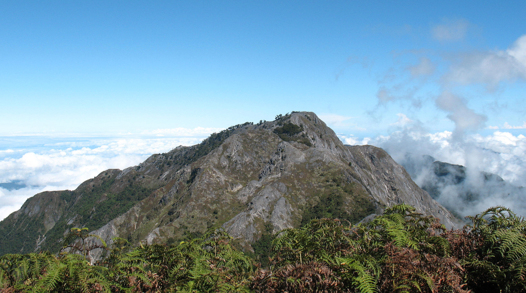
Mount Binaiya stands at 3,027 meters above sea level, locked inside Manusela National Park on Seram Island, Maluku Province. It carries the 88th highest topographic prominence on Earth and holds the title of the highest peak across the entire Maluku archipelago. What separates it from most mountains on the Indonesian seven summits list is its geological backbone.
The mountain sits on one of the most tectonically complex zones on the planet, where several microplates collide and overlap, forcing limestone bedrock upward across millions of years into what is now the defining karst mass of eastern Indonesia. The term "Maluku roof" is not poetic license. It is a structural fact written in ancient stone.

The Karst Giant That Holds Seram Island Together
The karst system embedded within Mount Binaiya and its surrounding Manusela National Park forms one of the largest and most ecologically dense limestone ecosystems in Indonesia. Water moves through the mountain differently here.
Rain that falls on karst surfaces percolates instantly through porous rock, creating underground rivers, cave networks, and subterranean chambers while the surface vegetation adapts to what functions like chronic drought despite heavy annual rainfall.
The park's karst zone holds the Hatu Saka cave system, currently the deepest documented cave in Indonesia at 388 meters, and shelters the Sapalewa underground river, recognized as one of the largest subterranean river systems on Earth. These are not footnotes, they are the structural identity of this mountain range.
Manusela National Park itself covers approximately 1,890 square kilometers, encompassing roughly twenty percent of Seram Island. The park administration in Masohi handles entry permits and coordinates with village-level authorities who maintain customary control over access corridors.
Any approach to the summit passes through this dual permitting structure, formal park authorization combined with indigenous community consent.
Five Vegetation Zones Between Sea and Summit
The climb from the Seram coastline to the summit ridge of Mount Binaiya passes through five distinct vegetation zones compressed into a single continuous ascent. No other approach in the Maluku islands delivers this level of ecological transition within a single expedition. Starting at zero meters above sea level, the coastal fringe carries mangrove systems and swamp forest with salt-tolerant species adapted to tidal influence.
Moving inland and upward, this transitions into lowland tropical rainforest characterized by high canopy density, maximum species diversity, and the highest concentration of the park's endemic fauna.
Above 600 meters, tree species richness begins to decline as the lower montane forest zone takes over. The air cools, the canopy lowers, and the soil chemistry shifts as organic carbon content increases with altitude while pH drops progressively.
Between 1,000 and 1,500 meters on the Binaiya slopes, tree species richness temporarily rebounds above what comparable altitude bands show on other Seram peaks, a documented anomaly tied to the specific geology of this mountain's southern face.
Mosses begin colonizing bark surfaces, and the first pitcher plants appear in sheltered drainage lines.
The upper montane zone above 2,000 meters transitions into subalpine forest where trees become stunted and moss layers thicken across every surface. Nepenthes pitcher plants persist here alongside the Binaiya Fern, a species botanically catalogued as Chinteya binaya, endemic to the summit ridge area and found nowhere else on Earth.
At the peak zone, the alpine vegetation is sparse, wind-shaped, and anchored into shallow soils over bare karst. The complete transition from coastal mangrove to summit alpine scrub within a single climb is the multimodal vegetation zone that makes Binaiya distinct from any other peak within the Manusela National Park system.
Nuaulu Customary Law: The Authority Structure Above All Permits
The Nuaulu are one of the indigenous ethnic groups of Seram Island whose territorial authority predates the existence of Manusela National Park by generations. Their customary law system, adat, governs resource use, spatial access, and human behavior within forests they have managed through encoded traditional regulations long before modern conservation frameworks arrived.
The Nuaulu speak a language distinct from other Seram sub-tribes and maintain an animist worldview organized around ancestral spirits, clan houses, and sacred ecological sites.
Within the Nuaulu system, the concept of Mount Binaiya Sasi functions as a customary resource management institution. Sasi designates specific areas, resources, or activities as protected under adat law, enforcing seasonal or permanent restrictions on extraction and access. When applied to the mountain corridor leading to Binaiya's summit, the Sasi mechanism translates directly into climbing access control.
Researchers at Sage Journals have documented how the Nuaulu use Sasi institutions alongside other protective designations including sin wesie, or sacred protected areas, and scare charm systems to regulate forest exploitation across their territory.
These are not symbolic gestures. They are functional governance instruments with enforced compliance from within the community and expected respect from outsiders.
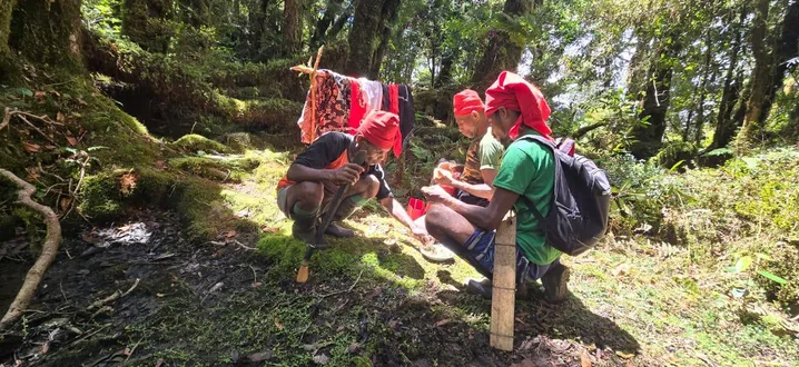
Climbers who enter through the northern approach route must interact directly with this authority structure before any upward movement begins. The customary permit, obtained through the village head and tribal elders of Kanikeh or Huaulu, carries equal or greater weight than the formal national park document.
Expedition operators with experience in this corridor explicitly instruct climbers to treat the adat permission process as the primary clearance, not a formality appended to the national park permit.
The Sasi Ritual and the Mountain Permission Ceremony of Mount Binaiya
Before any climb up Mount Binaiya can begin through the northern corridor, a traditional ritual ceremony must be performed at either Kanikeh Village or Huaulu Village. This ceremony, tied to the broader Sasi framework of the Nuaulu and affiliated highland communities, functions as both a spiritual clearance and a formal acknowledgment that the climber accepts the mountain's customary rules.
Skipping this ritual is not treated as an oversight. It is treated as a violation, and guides recruited from the villages will refuse to lead any party that has not completed the ceremony correctly.
The ceremony typically involves the village head or designated adat elder, offerings specific to local tradition, and spoken declarations that position the climber as a temporary guest within a landscape that belongs permanently to the indigenous community and the ancestral forces they recognize as active.
Expedition notes published by experienced climbers confirm that a traditional ceremony in Kanikeh is a standard requirement for the northern route, described as a protective ritual for the hikers. The ceremony is also a practical checkpoint, giving the village authority a moment to assess the physical readiness and group composition of incoming expeditions.
Guides and porters are assigned from the village at this stage, and their local knowledge of traps, forest trails, and weather patterns is operationally essential given the dense, unmarked terrain ahead.
Red Cloth of the Huaulu: The Karanu Headband as Living Culture
The men of Huaulu Village carry a distinctive visual marker that identifies them across the forest corridor of northern Seram. The karanu is a red cloth headband worn as standard dress by Huaulu men, a practice with deep cultural coding within their community identity. The red cloth is not ceremonial in the sense of being reserved for rituals.
It is a daily dress that marks belonging, lineage, and the unbroken continuity of Huaulu cultural practice in a region that has experienced significant external pressure from modernization, religious change, and population movement.
The Huaulu community has historically moved locations while preserving cultural practice intact, prioritizing the continuation of adat ways over fixed attachment to any single settlement site.
Their craft tradition includes weaving simple carrying bags from sago palm leaves, known as lopa-lopa, which climbers passing through the village can acquire and which function as a tangible material connection between the expedition and the community it passes through.
Researchers documenting Huaulu tangible and intangible cultural heritage have identified the combination of forest navigation knowledge, ancient ornamental motifs on clan house pillars, and the visual continuity of the karanu as the defining elements of Huaulu cultural identity within Seram Island's indigenous landscape.
Traditional Arts at the Foot of the Mountain
The villages positioned at the base approaches to Mount Binaiya preserve performance and material art traditions that have evolved within the ecological and social context of highland Seram. Dance forms tied to harvest cycles and ancestral commemorations remain active in community life rather than being staged exclusively for outside audiences.
The instruments used in these performances are constructed from forest materials specific to the Manusela region, and their construction methods are transmitted through direct intergenerational practice.
Woven crafts using sago palm fiber extend beyond the lopa-lopa bags documented in Huaulu and include textile pieces with geometric patterning that mirrors motifs carved into clan house structural elements. These motifs encode clan histories and territorial identifiers that serve as visual documentation of lineage and land relationship.
For climbers transiting through these villages, engagement with this art tradition provides context that purely logistical expedition preparation cannot.
The cultural production happening at the foot of Binaiya is not peripheral to the mountain experience. It is the community architecture that makes the customary permission system, the guided access, and the ritual ceremony structurally coherent.
The North Route Through Huaulu Village: Exotic Alternative Access
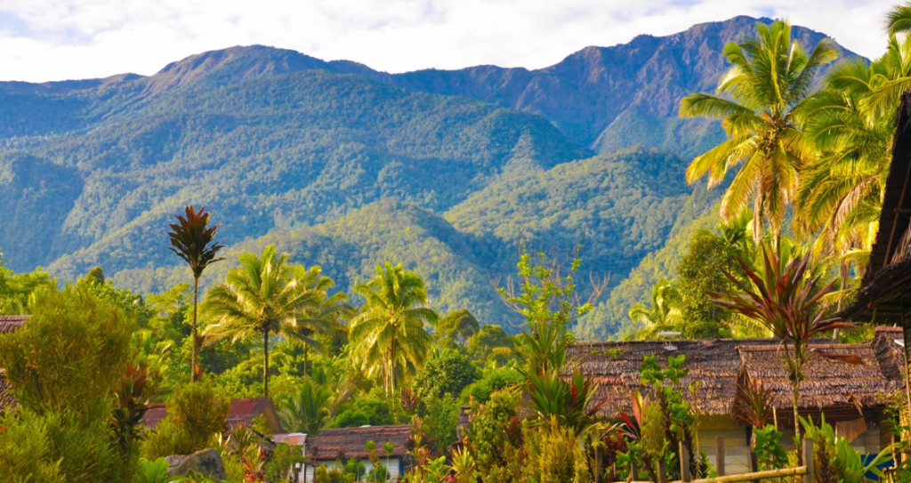
The northern approach to Mount Binaiya via Huaulu Village and the Pasahari corridor is less frequently documented than the southern Piliana route but offers a fundamentally different expedition character. The entry point for this route is accessed from Wahai on Seram's north coast.
From Wahai, the trail moves inland through Huaulu, continuing through Roho before reaching Kanikeh, the last permanent settlement before the summit push.
This corridor involves multiple river crossings, sustained steep grades through dense primary forest, and navigation conditions that make a qualified local guide non-negotiable rather than optional.
The northern route passes through the core territory of the Huaulu community, which means the cultural and customary dimensions of the climb are more directly experienced than on the southern approach.
Expedition logs from climbers who have completed both routes consistently describe the northern corridor as more demanding in terms of trail clarity and physical conditions, but significantly richer in terms of the environmental and cultural immersion it delivers.
The dense forest canopy here remains largely unbroken from the coast to the high-altitude zones, preserving the complete fauna corridor that makes the Binaiya northern slope one of the most ecologically intact mountain approaches remaining in eastern Indonesia.
Isal Valley: The Lost World Hidden Inside Seram
Within the Manusela National Park interior, the Isal Valley occupies a position that has earned it the designation of Seram's lost world among the limited number of trekkers who have documented the area. The valley sits at an elevation and geographic position that insulates it from the weather patterns affecting the main ridge routes, creating a microclimate with distinct humidity, temperature, and light conditions that support vegetation assemblages not present on the surrounding slopes.
The valley floor carries primary forest in an advanced successional state, with emergent trees reaching heights that indicate minimal human disturbance across extended periods. The river drainage moving through Isal feeds into the broader karst water system of the mountain, disappearing periodically into underground channels before re-emerging at lower elevations.
For expeditions using the northern approach, the Isal Valley represents a navigational waypoint that also functions as one of the most visually concentrated expressions of what Seram's interior forest looked like before any external contact modified it.
Access requires a guide with specific route knowledge of this corridor, as the valley's insulated geography that makes it ecologically exceptional also makes it spatially disorienting without local navigation support.
Binaiya Canopy at Dawn: Where Endemic Maluku Birds Fly First Light
The forest canopy along the approach trails to Mount Binaiya, particularly in the mid-elevation zones between 800 and 1,500 meters, functions as a primary habitat corridor for Seram's most significant endemic bird species. Dawn in this zone delivers the highest observation density, when temperature inversion pushes bird activity to the canopy surface before midday heat drives them into the forest interior.
The Seram Cockatoo, classified scientifically as Cacatua moluccensis and listed as Endangered on the IUCN Red List, moves through this canopy in small groups at first light. As the largest white cockatoo species reaching up to 52 centimeters in height, its salmon-pink crest and distinctive calls make it identifiable at distance through the forest.
Seram Island's 117 documented bird species include 14 endemic species and subspecies, creating a concentration of localized endemism that exceeds most other islands in the Maluku system. The Tanimbar Lory and other lory species share the canopy dawn window with the cockatoo, creating multi-species observation moments that specialist birdwatchers specifically route expeditions to capture.
This viewpoint zone along the Binaiya approach is not a secondary attraction appended to the summit objective. For a segment of the global birding community, it is the primary destination.
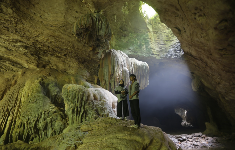
Kanikeh Underground Karst Cave: The Limestone Vault Below the Summit
Below Kanikeh Village, the karst geology of the Mount Binaiya massif produces underground cave formations accessible to expeditions that plan for the detour. The Kanikeh karst cave system is part of the broader limestone cave network embedded throughout Manusela National Park, a park whose geological profile is defined by dramatic limestone formations, deep valleys, and cave systems produced through centuries of water moving through soluble bedrock.
The cave surfaces carry speleothem formations, the stalactites and stalagmites that accumulate from mineral-laden water dripping through cave ceilings over geological timescales.
The karst geography here connects hydrologically to the Seram karst system that includes the Hatu Saka cave to the north, currently Indonesia's deepest documented cave at 388 meters, and the Sapalewa underground river. The Kanikeh cave represents the accessible entry point into this system for expeditions approaching from the village, offering a subterranean contrast to the vertical summit objective above.
The cave's darkness, temperature drop relative to the forest exterior, and the specific acoustic environment of its chambers produce a sensory context that documents the mountain's underground identity, the hidden geological infrastructure that makes the karst ecosystem above ground function the way it does.
Wayula Savannah: The Shadow Peak Platform for Milky Way Observation
At the elevation band where Wayula Savannah opens on the Binaiya approach corridor, the forest canopy breaks and a clear horizontal platform presents itself against the mountain's upper profile. The savannah formation here is a high-altitude grassland embedded within the otherwise continuous forest cover, produced by a combination of soil chemistry, drainage patterns, and historical fire disturbance that prevented forest re-establishment.
This clearing creates a direct line of sight to the upper ridgeline of Mount Binaiya, earning it the functional designation of shadow peak viewpoint among climbers who have staged here.
The practical significance of Wayula Savannah extends past daylight observation. At elevation and removed from any settled area by multiple days of trekking, this location carries zero artificial light contamination.
The night sky above Wayula Savannah delivers the full-spectrum Milky Way that coastal and lowland positions in Indonesia have lost entirely to light pollution from urban and fishing activity.
Astrophotography expeditions that route through the Binaiya northern corridor specifically identify Wayula as the optimal staging point for long-exposure night photography of the galactic core.
The combination of savannah horizon clearance, altitude above the humidity layer that softens coastal night skies, and total absence of light interference places this location among the highest-quality astrophotography positions accessible within the Indonesian archipelago without specialized high-altitude mountaineering equipment.
Practical Logistics and Entry Architecture for the Binaiya Expedition
Approaching Mount Binaiya from the regional hub requires flying into Ambon, the capital of Maluku Province, followed by a ferry crossing from Tulehu Port to Masohi on Seram Island, a transit of approximately two hours. From Masohi, the southern approach continues overland to Piliana Village, the entry point for the southern route, requiring approximately three hours by road.
The northern approach requires continuing from Masohi to the north coast road and reaching Wahai, a longer overland transit, before entering the Huaulu corridor.
National park entry permits are processed through the PHKA office in Masohi, and expedition organizers with prior coordination capability can arrange these in advance of arrival on the island.
The minimum duration for a complete summit expedition via either route is seven to ten days from Ambon, accounting for travel, village stays, acclimatization, the ascent, and the descent. Physical preparation requirements are significant.
The terrain involves sustained steep grades on wet, unstable surfaces, multiple river crossings, and navigation through primary forest with no maintained trail infrastructure. A medical fitness certificate is required by some operators as a condition of guided service.
Expedition cost structure includes guide and porter fees paid through the village authority system, park permit fees, and inter-island transport. All gear for multi-day camping must be carried in, as no infrastructure exists above the last village.
The Indonesia seven summits context positions Binaiya as the eastern anchor of the national mountaineering challenge, making it a target for domestic climbers completing the full sequence alongside those approaching from international trekking circuits.