
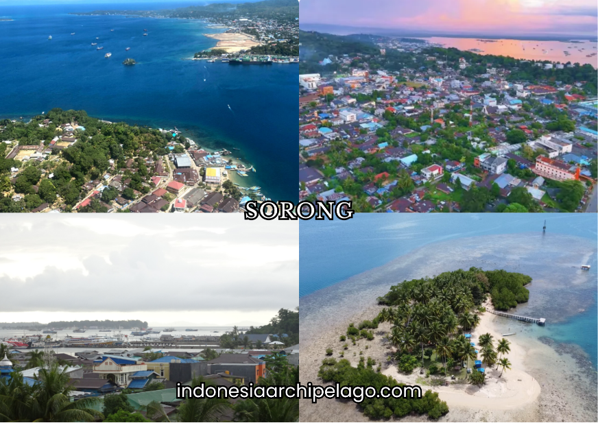
Sorong City occupies the northwestern tip of the Bird's Head Peninsula (Kepala Burung) of New Guinea, positioned at approximately 0°52' South latitude and 131°15' East longitude along the shores of the Dampier Strait. As the capital of Southwest Papua Province, one of the new provinces created through the 2022 Papua regional expansion legislation, Sorong City functions as the primary administrative, commercial, and logistics hub for a province whose territory encompasses the Bird's Head and Bird's Neck regions of western New Guinea. Its position as the mandatory transit point for Raja Ampat, the most internationally recognized marine tourism destination in Indonesia, gives the City a tourism economy role that operates at a scale disproportionate to its population and urban development level.
Bird's Head Peninsula, Coastal Topography, and Sorong's Administrative Layout
The topography of Sorong City combines a narrow coastal plain with rapidly rising forested hills that characterize the Bird's Head Peninsula's geological structure. The city sits at the junction of the Dampier Strait and the Sele Strait, flanked by island clusters including Doom Island and Salawati Island that shape the harbor geometry and maritime traffic patterns of the port zone.
Tidal variation and coastal sediment dynamics along the city waterfront have required ongoing port maintenance investment to sustain navigable depths for the commercial vessels that constitute the city's economic lifeline.
Sorong City is administratively divided into 10 districts (kecamatan) and 56 urban villages (kelurahan), covering a total land area of approximately 1,105 square kilometers including extensive forested hinterland beyond the urban core.
The administrative expansion reflects Sorong's 2003 elevation to independent city status, separating it from Sorong Regency and establishing the urban municipality as a distinct governance unit.
The coastal districts of Sorong Barat and Sorong Manoi concentrate the port, commercial, and government infrastructure, while inland districts contain the residential expansion zones absorbing population growth driven by resource industry and transit economy employment.
From "Soren" to BPM Oil Colony to the Capital of Southwest Papua Province
The name Sorong derives from the indigenous Moi language word "soren," referring to the sea or the coastal zone that defined the original Moi people's relationship with the Bird's Head coastline.
The Moi are the indigenous inhabitants of the Sorong area, an Austronesian-speaking group whose fishing and sago-based subsistence economy was organized around the island and coastal geography of the northwestern New Guinea shore long before external commercial contact.
Dutch colonial interest in Sorong intensified dramatically following the discovery of oil deposits in the Bird's Head region in the early 20th century. Bataafsche Petroleum Maatschappij (BPM), the Dutch-Shell joint venture that dominated colonial petroleum exploration in the Netherlands East Indies, established extraction and processing infrastructure at this city beginning in the 1930s.
The oil infrastructure created a planned industrial settlement with Dutch expatriate quarters, worker housing, port facilities, and road connections to the interior drilling sites that constituted Sorong's first modern urban infrastructure.
The BPM period established Sorong's identity as a resource extraction city oriented toward external capital and external markets rather than toward indigenous economic development.
This foundational character of a city built by and for an extractive industry operating at the edge of mapped territory persists in the structural features of Sorong's economy, where energy corporations, logistics companies, and transit service providers dominate the formal employment base.
How the Petroleum Era Transformed Sorong City Into a Strategic Eastern Hub
The transition from Dutch to Indonesian sovereignty in 1949 transferred BPM's Sorong assets to Pertamina, the Indonesian state oil company, which continued and expanded petroleum production operations across the Bird's Head region.
Sorong's port and logistics infrastructure, originally built for oil industry supply chains, was progressively adapted to serve the broader commercial and government functions of an expanding Indonesian administrative presence in western New Guinea following the 1969 Act of Free Choice that incorporated the territory into Indonesia.
The city's growth through the New Order period was driven by a combination of transmigration settlement, military and government personnel deployment, and the expansion of fisheries and timber industries alongside the continuing petroleum sector.
This layered economic base produced a more diversified urban economy than pure oil towns typically develop, though the petroleum sector continued to define the city's infrastructure scale and corporate presence through the late 20th century.
Southwest Papua Province's creation in 2022 through the Papua regional expansion legislation elevated this city from a regency capital to a provincial capital, triggering a new cycle of government building, institutional establishment, and infrastructure investment that is currently in active development.
The provincial capital designation represents the most significant structural change to Sorong's administrative and economic position since the Indonesian integration period.
Shared City Identity, Majority Ethnicities, and the Heterogeneity That Works
Sorong City's population composition reflects its history as a resource industry and transit hub that has drawn migrants from across Indonesia alongside its indigenous Moi and wider Papuan population base.
The city is informally described as a "kota transit" a transit city where people from Sulawesi, Maluku, Java, and other Indonesian regions have established commercial and residential presences organized around the port economy, fishing industry, and government employment sectors.
The Moi indigenous community maintains cultural and land rights claims across the Sorong area and has engaged with the provincial government on recognition frameworks for customary land tenure within the urban expansion zone.
Alongside the Moi, broader Papuan communities from multiple ethnic groups across the Bird's Head region are represented in Sorong's population. Buginese, Makassarese, Ambonese, Javanese, and Chinese-Indonesian communities occupy distinct commercial niches in the market and service economy.
The "shared city" characterization reflects a pragmatic social equilibrium built on commercial interdependence rather than deep historical coexistence. The city's rapid growth and its function as a transit point for diverse populations moving through for work, trade, and tourism have produced a social environment where transactional relationships dominate over the more intimate inter-ethnic frameworks found in older cities with longer histories of mixed settlement.

Sorong Papuan Malay Dialect, Regional Languages, and Street Slang in Use
Papuan Malay, the creole variety of Malay that functions as the lingua franca across the Papuan provinces, is the primary medium of daily communication in this City across all ethnic groups.
The Sorong variety of Papuan Malay incorporates vocabulary and phonological features from the Moi language alongside influences from Maluku Malay, reflecting the geographic and cultural position of the Bird's Head at the intersection of the Papuan and Maluku linguistic zones.
Common everyday expressions in Sorong Papuan Malay include "beta" (I/me), "ko" (you), "dong" (they/them), and "su" (already/done), particles shared across the broader eastern Indonesian Malay creole continuum.
Sorong-specific slang draws on the city's port and transit identity, with expressions related to boat schedules, loading operations, and inter-island movement embedded in casual speech.
The Moi language itself is maintained within the indigenous community and in ceremonial contexts, representing the linguistic heritage of the Bird's Head's pre-colonial human geography.
PBD Governor's Office Defines the New Administrative Axis of Sorong City
The Governor's Office of Southwest Papua Province (Provinsi Papua Barat Daya, PBD) established in Sorong following the 2022 provincial creation represents the primary new civic landmark of the city's transformed administrative status.
The governor's office complex anchors the provincial government district being developed in Sorong, concentrating the institutional infrastructure of a new provincial administration executive offices, legislative assembly, secretariat, and line ministry regional offices in a planned government precinct that is reshaping the city's spatial hierarchy.
The establishment of full provincial government infrastructure in Sorong is a multi-year construction and institutional development process. The PBD governor's office has operated from transitional facilities while permanent government buildings are developed, a pattern familiar from other Indonesian new province capital development processes including Sofifi in North Maluku.
The completed government precinct will function as the definitive civic center of Sorong City's identity as a provincial capital rather than a resource industry town.
Doom Island Carries the Exotic Weight of Sorong City's Oldest Urban Layer
Doom Island, a small island approximately 2 kilometers offshore from the city waterfront, carries the oldest layer of formal urban settlement in the Sorong zone. The Dutch colonial administration used Doom as a base for early government and commercial operations before mainland infrastructure was sufficiently developed to support administrative functions.
Colonial-era buildings, a lighthouse, and the remnants of early 20th century settlement infrastructure remain on the island, giving it a heritage character that contrasts with the newer mainland city development.
Doom Island is accessible by short boat crossing from the Sorong waterfront and functions as a day tourism destination for visitors interested in the colonial history layer of Sorong's urban development. The island's small permanent population maintains fishing activity and basic services.
Conservation of the colonial-era building stock on Doom has been discussed within heritage preservation frameworks, though the island's limited infrastructure and accessibility constraints have slowed formal heritage management program implementation.
Tanjung Kasuari Beach, Sorong Nature Park, and the Ayamaru Lake Corridor
Tanjung Kasuari Beach, located on the northern coastal edge of Sorong City, provides the primary accessible beach destination for the city's resident population and for transit visitors waiting for Raja Ampat connections. The beach features white sand and clear water with views across the Dampier Strait toward the Raja Ampat island silhouettes on the western horizon.
Facilities including food stalls, parking infrastructure, and basic beach amenities have been developed to serve the growing recreational demand from Sorong's expanding urban population.
Nature Tourism Park (Taman Wisata Alam Sorong) in the city's forested hinterland provides accessible lowland tropical forest for nature observation, bird watching, and short trail walking. The Bird's Head Peninsula is recognized by ornithologists as one of the world's most significant bird diversity zones, with Raja Ampat's avifauna including multiple endemic species.
The accessible forest near Sorong City offers entry-level bird watching opportunities for visitors who cannot extend their stay to the more remote interior sites.
Ayamaru Lake, located in the Ayamaru district of Southwest Papua approximately 200 kilometers southeast of Sorong, is a natural lake system embedded in karst limestone terrain that supports exceptional freshwater biodiversity including endemic fish species.
The lake is the spiritual and cultural heartland of the Ayamaru people and functions as an ecotourism destination for visitors making the Trans-Papua road journey into the Bird's Head interior.
Shopping Centers, Urban Leisure Infrastructure, and the Raja Ampat Transit Economy
Sorong City's retail landscape is anchored by Sorong Trade Center and several mid-format shopping facilities that serve the city's permanent population and the continuous flow of transit visitors moving between Sorong and Raja Ampat.
This transit economy, encompassing accommodation, food and beverage, equipment rental, and tour services for international and domestic visitors to Raja Ampat, represents a retail and service demand stream that operates independently of the resident population's consumption patterns.
The Raja Ampat transit function means that Sorong's hospitality sector serves an international visitor demographic with higher spending capacity than most eastern Indonesian cities of comparable size.
Hotels, dive equipment retailers, tour operators, and boat charter services concentrated near the Sorong port constitute a specialized tourism service cluster oriented entirely toward the Raja Ampat departure point function. This cluster has grown substantially with the international recognition of Raja Ampat as a global dive and nature tourism destination.
Timor Ayamaru Cloth and Crocodile Leather Craft as the Creative Identity
Timor Ayamaru cloth is a traditional woven textile from the Ayamaru community of the Bird's Head interior, featuring geometric patterns and color combinations that reflect the Ayamaru's cultural identity and natural environment.
The weaving technique uses backstrap loom methods and natural dye materials sourced from forest plants, producing textiles whose color palette and pattern vocabulary distinguish them from the better-known ikat traditions of eastern Nusa Tenggara.
Provincial craft promotion programs have worked to develop commercial distribution channels for Ayamaru cloth through Sorong City's artisan market infrastructure.
Crocodile leather craft production in Sorong draws on the saltwater and freshwater crocodile populations of the Bird's Head's coastal and riverine ecosystems. Regulated harvest and processing of crocodile leather feeds into a craft and luxury goods production chain that produces wallets, belts, bags, and decorative items marketed through Sorong craft retailers and export buyers.
The product occupies a high-value niche within the broader Papuan craft economy and is subject to CITES international trade regulations governing crocodilian product commerce.
Crude Oil, Natural Gas, and Deep Sea Exports Anchor the Commodity Base
The petroleum sector remains the foundational commodity base of the Sorong City economy, with crude oil and natural gas production from Bird's Head fields operated by Pertamina and international production sharing contractors flowing through Sorong's energy logistics infrastructure.
The Sorong refinery, one of the older refinery facilities in the Indonesian national network, processes local crude for regional fuel supply, reducing the logistics costs of fuel distribution across the western Papuan island chain.
Deep sea fisheries in the Cenderawasih Bay, Seram Sea, and the waters surrounding the Raja Ampat archipelago contribute tuna, snapper, grouper, and reef fish to both domestic and export supply chains moving through Sorong's fishing port.
The richness of the marine environment in the Coral Triangle zone surrounding the Bird's Head makes western Papua one of the most productive fisheries regions in the world, and Sorong functions as the primary landing, processing, and export hub for this output.

Papeda Yellow Sauce, Cheating Shrimp, and Abon Roll Bread on Every Table
Papeda with yellow fish sauce is the defining staple of Papuan food culture, shared across the Bird's Head and Papuan mainland urban food environments. In Sorong, the preparation uses locally sourced tuna, snapper, or mackerel simmered in turmeric-based yellow broth with lemongrass, ginger, and lime leaves, served alongside sago papeda pulled into strands with bamboo forks.
The dish is consumed at all meal times and is available at dedicated papeda stalls concentrated in the Sorong market district and at food courts across the city.
Udang selingkuh — literally "cheating shrimp" — is a freshwater crustacean (Cherax species) whose claws resemble those of a lobster rather than a typical shrimp, producing its colloquial name. The creature is endemic to Papuan freshwater systems and has become the signature high-value culinary item of Sorong restaurants serving both local and tourist customers.
Its visual distinctiveness and premium flavor profile make it the most photographed dish associated with Sorong's food identity. Abon roll bread, a soft bread roll filled with shredded seasoned fish or meat floss (abon), is a widely consumed everyday snack available from bakeries and street vendors across the city, reflecting the practical food preferences of a port city population with mobile, labor-intensive work patterns.
Energy Corporations, Financial Centers, and the Southwest Papua Corporate Map
The corporate landscape of Sorong City is dominated by energy sector companies of Pertamina operational units, international oil and gas contractors, oilfield services providers, and marine logistics companies supporting offshore extraction operations. These companies maintain the largest formal employment base, the most significant procurement activity, and the greatest infrastructure investment in the city's private sector economy.
The transition to Southwest Papua Province status has added a layer of provincial government-linked corporate activity as new provincial institutions establish procurement, construction, and service contracts with local and national vendors.
The financial sector in Sorong includes regional offices of state banks and the newly established Southwest Papua regional development bank framework. Bank Papua, serving both Papua and the new Papuan provinces, maintains Sorong operations alongside BRI, BNI, Bank Mandiri, and private commercial lenders.
The banking sector's scale is driven by a combination of government payroll, energy sector corporate transactions, and the growing SME sector serving the transit and fisheries economies.

Maritime Cluster, Boatbuilding Industry, DEO Airport, and City Port Access
The Sorong maritime cluster encompasses ship repair facilities, traditional and semi-modern boatbuilding yards, fishing vessel services, and the inter-island ferry infrastructure that connects the city to Raja Ampat, Manokwari, Fakfak, and the broader western Papuan island network.
Traditional boatbuilding using local timber species is practiced by Papuan and Bugis craftspeople whose vessels serve the small-scale fishing and inter-village transport economy across the Bird's Head coastal zone. Semi-modern fiberglass speedboat construction for the Raja Ampat tourism and inter-island transport market has grown as a manufacturing activity within the Sorong maritime cluster.
Domine Eduard Osok Airport (DEO), located within the city boundary approximately 5 kilometers from the port, serves domestic routes to Jakarta, Makassar, Manado, Ambon, Manokwari, and Raja Ampat's Waisai Airport.
The airport's central location within the city has created both accessibility advantages and urban development constraints as residential and commercial expansion presses against flight path safety zones.
Capacity expansion discussions have addressed both terminal throughput and runway length limitations that restrict the aircraft types and route economics available to Sorong's aviation market.
Trans-Papua Artery, Sea Toll Road, and the Sorong SEZ Industrial Projection
The Trans-Papua Highway, connecting Sorong eastward through Manokwari, Nabire, Wamena, and toward Jayapura, represents the most ambitious land infrastructure project in Indonesian history by terrain difficulty and construction cost per kilometer.
The western segment linking Sorong to Manokwari has been progressively developed, providing a land corridor that supplements the sea and air connections that previously constituted the only transport options between Bird's Head cities.
The Trans-Papua route reduces logistics costs for agricultural and manufactured goods moving between Sorong and the interior Bird's Head communities, though terrain and maintenance challenges mean the sea connection remains primary for bulk commodity movement.
The western corridor sea toll road (tol laut) designation includes Sorong as a primary eastern node in the national maritime logistics network, with subsidized shipping frequency connecting Sorong to Java-based distribution hubs and to the intermediate Maluku and Sulawesi ports along the route.
The sea toll road program has measurably reduced the price differential for consumer goods between Sorong and Java, addressing a structural cost disadvantage that had historically limited purchasing power and business investment in the western Papuan economy.
The Sorong Special Economic Zone projection designates a coastal industrial area near the port for development as a manufacturing and processing hub leveraging Sorong's position at the intersection of Bird's Head resource supply chains and the Trans-Pacific logistics corridor.
The SEZ concept targets fisheries processing, downstream petroleum product manufacturing, and maritime industries as primary tenant sectors, aiming to capture more value from the resource flows that currently pass through Sorong as raw commodities toward processing facilities in Java and export markets.