
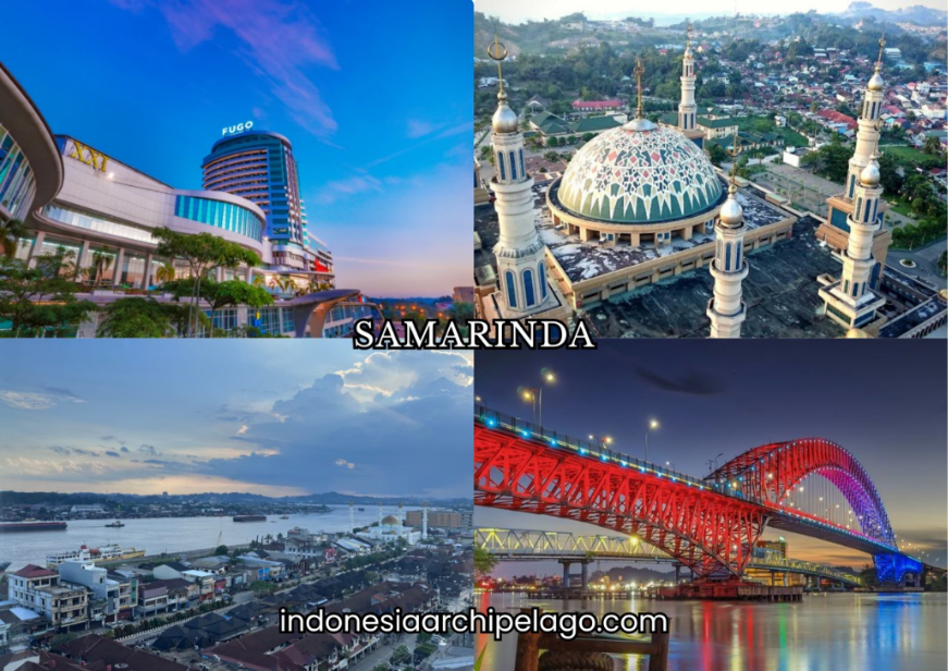
Samarinda City stands as the administrative anchor of East Kalimantan Province and one of Borneo's most strategically loaded urban centers. Positioned on the banks of the Mahakam River roughly 50 kilometres upstream from its delta mouth at the Makassar Strait, the city has functioned as a logistics command point since the 17th century, when Bugis settlers from Sulawesi established a trading settlement under the protection of the Kutai Sultanate. What makes Samarinda particularly consequential in 2025 and beyond is its proximity to Nusantara, Indonesia's new national capital being constructed in East Kalimantan, which has elevated the city from a provincial capital into a nodal component of the most ambitious urban development project in Indonesian history.
Samarinda City on East Kalimantan's River and Hill Terrain
The municipality covers approximately 718 square kilometres of mixed terrain on the eastern coast of Borneo. The city's western and southern flanks rise into undulating hills reaching up to 260 metres at Puncak Samarinda, while the riverfront zones and low-lying eastern districts occupy the flat alluvial terrain of the Mahakam flood plain.
Mahakam River roughly 430 metres wide at the city center, divides Samarinda into two urban halves known as Samarinda Kota on the northern bank and Samarinda Seberang on the southern. Two smaller rivers, the Karangmumus to the east and the Karangasem to the west, border the urban core and feed into the Mahakam downstream.
Administratively, Samarinda is divided into ten kecamatan and operates as the capital of East Kalimantan Province, a territory covering over 127,000 square kilometres that includes major coal, timber, and palm oil production zones. The city sits at near-zero latitude, placing it in a tropical rainforest climate zone with high rainfall distributed throughout the year and no meaningful dry season.
One notable geographic distinction is that Samarinda contains a 212,000-hectare production forest within its municipal boundary, giving it the unusual profile of a provincial capital that also manages a commercial forest estate at its geographic core.
From the Bugis Landing to Colonial Port and Provincial Capital
The founding of Samarinda traces to January 21, 1668, when Bugis settlers led by La Mohang Daeng Mangkona arrived from Wajo in Sulawesi following the Kingdom of Gowa's defeat by the Dutch VOC in 1667. The Treaty of Bongaja forced the Gowa Sultanate's submission and effectively displaced a portion of the Bugis warrior and trading class, pushing them eastward toward Borneo.
The Sultan of Kutai granted the Bugis settlers the right to establish a village at the Mahakam riverbanks in exchange for military loyalty, an arrangement that transformed what had been a Kutai administrative zone into a multicultural trading post.
Dutch colonial formalization began in earnest through the 1825 treaty with the Kutai Sultanate, which granted the VOC's successor administration trading privileges along the Mahakam. By 1844, following internal conflicts within the sultanate and Dutch military intervention, Samarinda became the administrative center of the Dutch colonial presence in eastern Kalimantan.
Late 19th and early 20th centuries brought coal mining development to the surrounding hills, attracting Dutch extraction companies and cementing Samarinda's role as the export funnel for East Kalimantan's natural resource economy.
After Indonesian independence, the city was formally constituted as a municipality on June 26, 1959, and became the provincial capital of East Kalimantan when the province was established.
Bugis-Kutai Heritage, Javanese Migration, and Multiethnic Harmonization
The population of Samarinda reflects the layered migration history of East Kalimantan more comprehensively than most Indonesian provincial capitals. The original Bugis settler community, descendants of La Mohang Daeng Mangkona's group, remains identifiable in the Samarinda Seberang district where the sarong weaving tradition they established persists across hundreds of household workshops.
The Kutai Malay community, the indigenous ruling ethnic group of the broader Mahakam basin, contributes a distinct cultural stratum shaped by the sultanate's Islamic governance tradition and river-based cosmology.
Javanese migrants constitute the largest single ethnic group in East Kalimantan Province at approximately 29 percent, with Bugis the second at 18 percent and Banjar at 14 percent, followed by Dayak and Kutai communities. In Samarinda specifically, Javanese labor migration tied to the coal and timber industries from the 1970s onward produced dense Javanese-majority neighborhoods on the city's periphery.
The Dayak Kenyah community, originally from the Mahakam interior highlands, established a resettlement village north of the city that became the Pampang Cultural Village. The city's social environment operates through a practical multiculturalism oriented around commercial interaction, with Banjar Malay functioning as the dominant lingua franca across ethnic lines in market and neighborhood settings.
The Banjar-Bugis Dialect Layer and Samarinda's Daily Language
The spoken language environment of Samarinda is organized around Banjar Malay as the primary interethnic communication register. Banjar, a Malay dialect originating from the Banjar people of South Kalimantan, spread through trading networks along the Mahakam and became the default market language for communities of different ethnic backgrounds needing a shared practical code.
Its vocabulary draws on Malay roots with significant Javanese and Dayak lexical borrowing, producing a speech register that differs substantially from standard Indonesian in its rhythm, vocabulary, and pragmatic conventions.
The Bugis dialect spoken in Samarinda Seberang retains features of the South Sulawesi original while incorporating Kalimantan-specific vocabulary accumulated over more than three centuries of settlement.
Among younger generations in the city, Indonesian increasingly dominates as the default language for education, social media, and mixed-company settings, while Banjar and Bugis function as community-internal registers for family and neighborhood use.
Street-level slang in Samarinda blends elements from all three layers, producing a casual speech register with distinctive intonation patterns that speakers from other Indonesian regions can identify immediately as characteristic of the Mahakam basin.
Islamic Center Mosque, the Mahakam Bridge, and Samarinda's Skyline Anchors
Samarinda Islamic Center Mosque standing on the Mahakam riverbank in the Teluk Lerong Ulu neighborhood, is the dominant architectural landmark of the city and one of the largest mosques in Southeast Asia. The complex covers a total built area exceeding 43,500 square metres and is framed by seven minarets, with the central tower rising 99 metres and the overall structural height reaching 107 metres above ground.
Riverside mosque’s position makes it visible from the Mahakam Bridge and from vessels moving along the river, giving it a skyline presence that defines how Samarinda is visually represented in regional media and travel documentation. The site was formerly occupied by a PT Inhutani I sawmill operation, and its conversion into a religious and civic landmark reflects the city's post-timber-era identity shift.
Mahakam Bridge, built in 1987 and spanning the river between Samarinda Kota and Samarinda Seberang, functions both as a critical traffic artery and as a symbolic gateway to the interior of East Kalimantan.
The bridge carries the primary road connection between the city center and the southern bank districts, and historically served as the main land entry point for overland travel upriver before the Balikpapan-Samarinda toll road restructured the city's accessibility profile.
A second crossing at the Palaran district adds capacity for freight vehicle movement tied to the container port downstream.
Pampang Village, River Cruises, and Cultural Heritage Tourism
Pampang Cultural Village, located approximately 20 to 40 kilometres north of Samarinda's city center depending on the route taken, is the primary cultural heritage tourism destination accessible from the city. The village was established by Dayak Kenyah communities who migrated from the Mahakam interior highlands in the 1970s and 1980s and resettled in the area under a government-facilitated program.
Today, the community maintains traditional Kenyah long house architecture, holds regular performance events featuring Kenyah dance, music, and ritual display, and operates a market for Dayak craft products including beadwork, carved wooden objects, traditional textiles, and characteristic ear-stretching ornamental jewelry that marks senior Kenyah cultural identity.
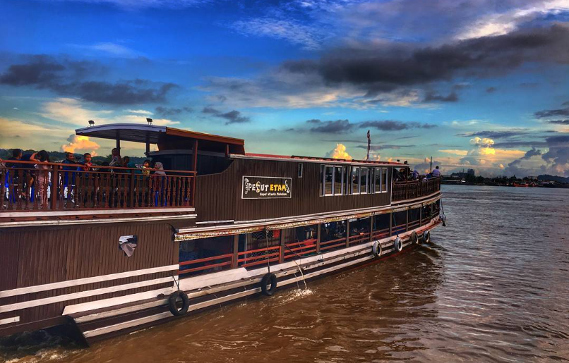
Mahakam River cruises departing from the Samarinda city waterfront provide access to riverside kampung settlements, traditional fishing communities, and the transition zone where urban infrastructure gives way to the river's forested interior corridor.
The Tepian Mahakam promenade on the northern riverbank has been developed as a public leisure strip with food stalls, night market vendors, and the Pesut Mahakam dolphin monument commemorating the freshwater Irrawaddy dolphin endemic to the Mahakam basin.
Upstream from Samarinda, the river opens into the lake district of the Mahakam interior, a region of oxbow lakes, peat swamps, and Dayak longhouse communities that forms one of the most distinctive river tourism corridors in Borneo.
Shopping Centers, Night Markets, and Samarinda's Modern Urban Offer
The commercial retail landscape of Samarinda has expanded substantially over the past two decades through the development of mall-format shopping centers including Samarinda Central Plaza, Big Mall Samarinda, and Mall Lembuswana, which anchor the city's modern consumer economy alongside the older Citra Niaga shopping complex in the city center.
Citra Niaga, an award-winning open-air market complex covering 2.7 hectares in the Samarinda Kota district, combines souvenir retail, food stalls, and craft vendors in a pedestrian-friendly layout that has been cited as a model for Indonesian traditional market redesign.
Night market activity concentrates along Jalan Sudirman and the Tepian Mahakam riverside strip, where food vendors, fresh produce traders, and street snack stalls operate from late afternoon through midnight.
Samarinda Seberang market district on the southern bank retains a more traditional commercial character, operating around the sarong weaving workshops and the Bugis community commercial networks that have defined that riverbank zone since the 18th century.
Sarong Weaving, Jepen Music, and the Creative Industry Base
The Samarinda sarong, woven on handlooms in home-based workshops concentrated along Jalan Bung Tomo in Samarinda Seberang, is the city's most internationally recognized craft product. The fabric is produced using premium silk threads in geometric patterns that retain design continuity with the Bugis textile tradition brought from Sulawesi in 1668.
Each piece requires multiple days of skilled handloom work, and the sarongs are sold at price points reflecting that labor intensity, making them a premium souvenir and ceremonial textile rather than a mass-market commodity. Buyers include collectors, ceremonial procurement officials from across Kalimantan, and export buyers supplying the Malaysian and Brunei Malay textile markets.
Contemporary ethnic music rooted in the Kutai and Bugis musical traditions feeds a local creative economy through performance, recording, and festival production. The Jepen dance and its accompanying musical genre represent the most commercially active Kutai cultural form, performed at official events, weddings, and tourism festivals.
Government support through the East Kalimantan provincial arts and culture agency sustains rehearsal facilities, performance stipends, and documentation initiatives for both Kutai and Dayak Kenyah performing arts traditions that might otherwise lose institutional support under the pressure of popular culture dominance.
Coal, Timber, and River Fisheries as Samarinda's Commodity Pillars
Coal is the defining economic commodity of East Kalimantan Province, and Samarinda functions as the administrative and logistics management center for a provincial coal sector that accounts for approximately 65 percent of Indonesian national coal output. The province's coal production contributes between 30 and 35 percent of its gross regional domestic product.
With concession areas concentrated in Kutai Timur and Kutai Kartanegara regencies but administered through Samarinda's government offices, banking infrastructure, and coal trading companies. The Mahakam River and its tributaries have historically served as the primary transport artery for coal moving from inland mining sites to coastal loading terminals.
Timber and log processing, once the dominant industry of East Kalimantan, retains a significant economic presence through plywood mills, wood processing facilities, and forestry management operations that still operate within the city's production forest zone and the surrounding regencies.
River fisheries from the Mahakam system supply fresh fish to Samarinda's markets daily, with the endemic Mahakam freshwater species including various carp and catfish varieties that form the raw material for amplang fish cracker production and the grilled fish dishes central to local cuisine.
Amplang, Nasi Kuning Seberang, and Cincane Chicken
Amplang is the culinary export product most associated with Samarinda beyond the province. The crispy fish cracker is produced from tenggiri mackerel or other Mahakam catch, mixed with tapioca starch and spices, and deep-fried into irregular puffed shapes with a distinctively brittle texture and savory fish flavor.
Samarinda's amplang industry operates across dozens of home-production facilities and several factory-scale operations, with products distributed nationally through airport souvenir retail, online marketplaces, and wholesale networks reaching Jakarta, Surabaya, and Balikpapan.
Nasi Kuning from the Samarinda Seberang weaving village carries a specific local identity tied to the Bugis community's ceremonial food tradition. The turmeric-yellow coconut rice is prepared with a particular spice profile that differs from the Javanese and Sundanese nasi kuning variants, served with fried chicken, tempoyak sambal, and dried fish accompaniments that reflect the Mahakam river community's pantry.
Ayam Cincane, the third culinary anchor, is a whole chicken preparation slow-cooked in a complex spice base featuring lemongrass, galangal, shrimp paste, and multiple dried chilies until the sauce reduces and caramelizes onto the meat, producing a richly flavored dish served at community ceremonies and in specialist restaurants throughout the city.
Mining Corporations, Regional Finance, and the Commercial Landscape
The presence of major coal mining corporations in Samarinda's commercial ecosystem is pervasive. Companies operating large concessions in East Kalimantan maintain regional headquarters, administrative offices, and procurement operations in Samarinda, making the city's office and hotel sector unusually oriented toward resource industry clients compared to typical Indonesian provincial capitals.
PT Kaltim Prima Coal, PT Berau Coal, and PT Adaro Energy's East Kalimantan operations all maintain logistics and administrative infrastructure feeding through Samarinda.
Regional finance is anchored by Bank Kaltimtara, the provincially owned bank serving East Kalimantan and North Kalimantan, alongside the Samarinda branches of Bank BRI, Bank BNI, Bank Mandiri, and Bank BTN.
The city's finance sector has expanded with the IKN development activity, as contractors, materials suppliers, and labor service companies entering the East Kalimantan market establish banking relationships and operational accounts through Samarinda's financial institutions before deploying operations toward the new capital construction zone.

Shipyards and the Mahakam River Vessel Economy
Shipbuilding and vessel maintenance operations along the Mahakam riverbanks constitute a significant industrial sector that receives relatively little national coverage relative to its actual scale. The river's importance as a freight artery for coal, timber, and agricultural commodities sustains continuous demand for river barges, tugboats, and specialized shallow-draft vessels capable of navigating the Mahakam's variable water levels and the narrowing tributaries leading to inland loading points.
Shipyard clusters operating in the Loa Janan and Muara Badak corridors south and north of the city perform construction, repair, and retrofitting of river cargo vessels using a mix of steel fabrication, traditional wooden boat construction techniques, and imported mechanical components.
The volume of river freight moving through Samarinda's waterway network supports a parallel vessel services economy covering fuel supply barges, crew placement agencies, ship chandlery operations, and marine safety equipment suppliers that collectively represent a substantial informal and semi-formal employment base alongside the formal shipyard sector.
APT Pranoto Airport, Palaran Container Port, and City Connectivity
Aji Pangeran Tumenggung Pranoto International Airport, located approximately 24 kilometres north of Samarinda's city center, serves as the primary air gateway for East Kalimantan alongside the larger Sultan Aji Muhammad Sulaiman Airport in Balikpapan.
APT Pranoto handles domestic routes connecting Samarinda to Jakarta, Surabaya, Balikpapan, and other Indonesian cities, with its capacity and route network expanded in response to the increased traffic generated by the IKN construction activity bringing contractors, government officials, and investors into the province at higher frequency.
Palaran Container Terminal, operated by PT Pelabuhan Samudera Palaran downstream from the city center, replaced the older Yos Sudarso Port facility that had reached capacity and expansion limits within the urban core. The terminal currently handles up to 250,000 TEUs annually and has been designated as a national vital object in connection with its role as a logistics support port for IKN supply chains.
Capacity expansion toward 400,000 TEUs annually is planned to meet the projected freight growth tied to capital construction and long-term IKN operational supply requirements. The Balikpapan-Samarinda Expressway, Kalimantan's first toll road completed in 2019, reduced travel time between the two cities from three hours to approximately one hour, integrating the Palaran port with Balikpapan's larger port and refinery infrastructure into a single functional logistics zone.
Mahakam River Logistics and the Trans-Kalimantan Road Network
The Mahakam River functions simultaneously as Samarinda's primary natural asset and its most complex logistics infrastructure. River barges carrying coal, plywood, palm kernel, and consumer goods move constantly between the upstream production zones and the downstream port facilities, with the city's waterfront serving as the interchange point where river freight transfers to coastal shipping.
Trans-Kalimantan Highway southern route passes through Samarinda as its eastern terminus on the Kalimantan-wide overland network, connecting the city westward through Balikpapan, across South Kalimantan, and ultimately to Pontianak in West Kalimantan, forming the spine of Borneo's land-based freight system.
IKN Toll Road branching south from the Balikpapan-Samarinda expressway corridor provides direct access between Samarinda and the Nusantara construction zone in North Penajam Paser Regency, cutting the overland connection time from Samarinda to the new capital to under two hours.
This road link has structural consequences for Samarinda's economic positioning, effectively making it the northernmost major supply city in the IKN logistical catchment area and ensuring that procurement, warehousing, and service industries supporting the new capital development locate preferentially within Samarinda's commercial zone.
Samarinda, Balikpapan, and the IKN Twin Cities Development Projection
The national spatial planning framework for Nusantara designates a tri-city metropolitan model linking the new capital with Balikpapan to the south and Samarinda to the north as the two urban anchors providing services, labor, governance, and logistics that the new capital city itself will not produce in its early development phases.
Samarinda's specific role in this framework centers on administrative governance, education, and the Mahakam river logistics corridor, complementing Balikpapan's port, refinery, and air connectivity functions.
The East Kalimantan provincial government's target of growing the regional economy four to five times by 2045 through IKN's development effects assumes that Samarinda absorbs a substantial share of the population and service economy growth generated by the capital relocation.
Land value escalation in the Samarinda-Balikpapan corridor, increased demand for skilled labor in construction and professional services, and expanded government spending flowing through Samarinda's banking and procurement systems are the immediate economic transmission channels.
Nusantara Capital Authority has designated 4.3 to 4.8 million new jobs as the employment target for East Kalimantan through 2045, a projection that positions Samarinda not merely as a provincial capital but as a permanent component of Indonesia's new national center of gravity.