
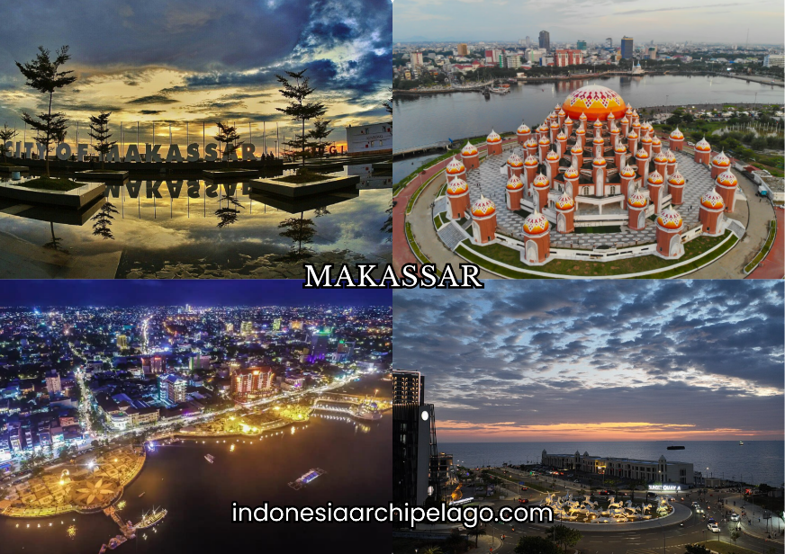
Makassar City occupies a strategic coastal position at the southwestern tip of Sulawesi, functioning as the primary administrative, economic, and cultural nucleus of eastern Indonesia. As the capital of South Sulawesi Province, Makassar City holds the classification of a Special Economic Region and stands among the four largest urban centers in Indonesia by population and economic output. The city's layered identity, shaped by centuries of maritime trade, kingdom politics, colonial intervention, and post-independence industrial development, makes it one of the most analytically complex urban environments in the archipelago.
Where Land, Sea, and Highland Corridors Converge
Makassar sits at approximately 5°8' South latitude and 119°25' East longitude, bordered directly by the Makassar Strait to the west. The city's topography is predominantly flat coastal lowland, with elevations ranging between 0 and 25 meters above sea level across most of its administrative area.
This low-lying character made the coastal zone historically susceptible to tidal inundation, a condition that shaped both settlement patterns and infrastructure investment decisions across the modern period.
The administrative geography of Makassar is divided into 15 districts (kecamatan) and 153 urban villages (kelurahan), covering a total land area of approximately 175.77 square kilometers. The districts vary significantly in density, land use intensity, and economic function.
Ujung Pandang and Wajo districts anchor the commercial core, while Biringkanaya and Tamalanrea in the northern periphery serve as expansion zones for industrial and educational facilities.
Geologically, the land base is composed primarily of alluvial deposits from the Jeneberang and Tallo rivers, both of which drain into Makassar Bay. The Jeneberang River in the south has historically served as both a freshwater source and a sediment corridor that shaped delta formation along the bay.
River basin management remains an active infrastructure concern given the city's flood exposure during the northwest monsoon season.
The Gowa-Tallo Kingdom and the Making of Makassar City
The political origin of Makassar as an urban entity traces directly to the dual-kingdom confederation of Gowa and Tallo, which achieved regional dominance across Sulawesi and portions of eastern Indonesia from the 14th century onward.
The Gowa Kingdom, centered at Sungguminasa south of the present city limits, controlled land-based agricultural production and military mobilization. Tallo, positioned closer to the coast, managed port administration, trade diplomacy, and maritime logistics.
By the early 17th century, the Gowa-Tallo confederation had converted to Islam and established Makassar as one of the most significant entrepôt ports in Southeast Asia. Traders from Arabia, India, China, Portugal, and the Dutch Republic operated simultaneously within the harbor zone.
The kingdom's Bugis-Makassar maritime network extended as far as the Philippines, the Banda Islands, and the northern coast of Australia, documented through both Dutch VOC records and indigenous lontara manuscripts.
The fall of the kingdom came with the signing of the Bungaya Treaty in 1667 following VOC military pressure led by Cornelis Speelman. The treaty effectively dismantled Makassar's independent trading authority and transferred port control to the Dutch.
This moment marks the beginning of the city's colonial restructuring, which proceeded through the 18th and 19th centuries under VOC and later Dutch East Indies administration.
Somba Opu Fortress and the Long Shadow of Ujung Pandang
Somba Opu Fortress, built in the early 16th century under the rule of King Daeng Matanre Karaeng Tumapa'risi' Kallonna, functioned as the principal defensive and administrative center of the Gowa Kingdom. Its walls, constructed from fired brick and coral stone, enclosed the royal palace, armory, and harbor command infrastructure.
Excavations conducted by the Archaeological Center of South Sulawesi have recovered cannon remnants, ceramics, and coinage that confirm the site's role as a high-volume commercial and military node.
After the VOC victory in 1667, the Dutch renamed the city Ujung Pandang, a name that persisted formally through much of the colonial and early independence period. The name change was not merely administrative.
It represented a deliberate erasure of the Gowa-Tallo political identity and a reassertion of Dutch territorial authority over the harbor zone. The name Makassar was officially restored in 1999 through regional government resolution, reconnecting the city's legal identity to its pre-colonial foundation.
The Somba Opu site today operates as an open-air cultural heritage complex south of the city. Reconstructed traditional houses representing multiple South Sulawesi ethnic groups are arranged across the grounds. The fortress ruins themselves are partially preserved, and the location is formally designated within the South Sulawesi provincial heritage protection framework.
Siri' na Paccé as the Living Moral Architecture of Society
The Makassar and Bugis ethnic groups share a foundational ethical framework known as siri' na paccé. Siri' refers to dignity, honor, and the social obligation to protect one's standing and the standing of one's family within the community. Paccé describes empathy, shared suffering, and solidarity with those in distress.
Together, the two principles form an interlocking moral code that governs interpersonal conduct, conflict resolution, and community obligation across both urban and rural contexts in South Sulawesi.
Siri' na paccé is not a static cultural artifact. It actively shapes behavior in commercial negotiations, political alliances, and social conflict in contemporary Makassar. Researchers in social anthropology have documented its influence in community dispute mediation, particularly in contexts where formal legal systems are perceived as inaccessible or ineffective.
The framework also informs the strong inter-ethnic solidarity networks that Bugis and Makassar diaspora communities maintain across the Indonesian archipelago. The ethnic composition of Makassar City reflects this cultural base. The Makassar ethnic group holds the largest demographic share, followed by the Bugis, Toraja, Mandar, and Javanese communities.
Chinese-Indonesian residents, concentrated largely in the Wajo commercial district, have maintained commercial networks in the city since the 17th century. This ethnic layering has produced a social environment characterized by competitive coexistence and cross-cultural commercial partnership rather than strict ethnic segregation.

Makassar Dialect, Regional Languages, and the "Ji" Particle
The Makassar language belongs to the South Sulawesi branch of the Austronesian language family. It is structurally distinct from Bugis, though the two languages share significant lexical overlap due to centuries of geographic proximity and political integration.
Makassar is written in the traditional Lontara script, a syllabic writing system derived from the Brahmic script family that was historically used for contracts, genealogies, and royal chronicles.
In everyday urban speech, Indonesian functions as the primary medium of communication in Makassar City, particularly in formal, commercial, and educational contexts.
The local variety of Indonesian spoken in Makassar is characterized by a distinctive intonation pattern and phonological compression compared to the Jakarta standard. This local Indonesian variant has generated a widely recognized set of colloquial markers, the most prominent being the particle "ji."
The "ji" particle functions as a pragmatic softener and emphasis marker. It attaches to the end of clauses to convey casualness, mild insistence, or social familiarity. Phrases such as "tidak apa-apa ji" (it's really nothing) or "sudah ji" (it's already done) are ubiquitous in informal Makassar speech.
The particle has spread beyond ethnic Makassar speakers and is now used broadly across all demographic groups within the city, functioning as a marker of local urban identity rather than ethnic affiliation.
Fort Rotterdam Stands as the Stone Memory of Colonial Power
Fort Rotterdam, known in Dutch as Fort Rotterdam and originally constructed as Ujung Pandang Fort by the Gowa Kingdom in 1545, represents the most intact colonial fortification complex in eastern Indonesia.
After the VOC takeover, the structure was extensively rebuilt between 1667 and 1669 under Dutch architectural direction, incorporating European bastioned fort design with pentagonal layout and thick laterite walls. The fort served as the primary administrative headquarters for Dutch control of eastern Indonesia for over two centuries.
The complex currently houses La Galigo Museum, one of the most significant repositories of South Sulawesi historical artifacts, including a comprehensive collection of Lontara manuscripts, traditional textiles, maritime instruments, and royal regalia.
The fort's interior courtyards and buildings have been partially restored and are accessible to visitors. It remains one of the primary heritage tourism assets of Makassar and is formally protected under Indonesian cultural heritage law.
Fort Rotterdam's significance extends beyond tourism. It functions as a physical reference point for urban planning decisions in the surrounding Ujung Pandang commercial district and is integrated into multiple academic and public history programs at regional universities, including Universitas Hasanuddin.
Center Point of Indonesia Redraws the Coastal Urban Edge
The Center Point of Indonesia (CPI) megaproject is a large-scale land reclamation and urban development initiative positioned along the western coastal edge of Makassar City. The project covers approximately 157 hectares of reclaimed land and is designed to accommodate a mixed-use district incorporating government administrative buildings, commercial towers, a national monument complex, cultural facilities, and waterfront public spaces.
The CPI project is framed within the national government's broader strategy to position Makassar as the primary urban gateway to eastern Indonesia, complementing the Nusantara capital relocation project in East Kalimantan. The symbolic significance of the CPI name reflects this ambition: Makassar City is geographically close to the longitudinal center of the Indonesian archipelago, and the monument at the site is intended to mark that geographic distinction.
Construction and land preparation have proceeded in phases since the initial planning period, with infrastructure development continuing through the mid-2020s. The reclaimed zone introduces new urban land supply into a city with limited flat inland expansion capacity, and it is expected to accommodate several major institutional and commercial tenants over the next development cycle.

Sangkarrang Islands and the Tallo Mangroves Marine Corridor
The Sangkarrang Islands, also referred to as the Spermonde Archipelago in older Dutch cartographic references, form a chain of low-lying coral islands extending westward from Makassar Bay into the Makassar Strait. The group includes Kodingareng Keke, Samalona, Bone Tambung, and several other smaller formations. The islands are administratively part of Makassar City and function as both active fishing communities and marine tourism destinations.
Water clarity, coral reef coverage, and fish species diversity in the Sangkarrang zone make it a viable destination for snorkeling and recreational diving from the urban center. Transport by motorboat from the Paotere Harbor area takes between 15 and 45 minutes depending on destination island.
The islands support livelihoods for Bajo Sea Nomad communities who have inhabited the region for generations and maintain traditional fishing practices tied to seasonal current patterns in the Makassar Strait.
The Tallo Mangrove Forest, located along the northern coastal edge of the city at the mouth of the Tallo River, represents one of the few remaining urban mangrove ecosystems in South Sulawesi. The Tallo mangroves serve ecological functions including coastal erosion control, juvenile fish habitat provision, and carbon sequestration.
Community-based conservation programs administered through local government agencies have expanded replanting efforts in the zone, though encroachment pressure from adjacent industrial and residential development remains a documented constraint.
Trans Studio and the Architecture of Urban Leisure in Makassar
Trans Studio Makassar, part of the Trans Corp entertainment and retail conglomerate, is the largest indoor theme park in Indonesia by total enclosed floor area. Located within the integrated Trans Studio Mall complex in the Tanjung Bunga coastal development zone, the facility combines a theme park, hotel, convention center, and retail mall within a single connected structure.
Since its opening, it has functioned as the primary anchor destination for domestic tourism and urban leisure consumption in Makassar City.
The Trans Studio complex reflects the broader pattern of large-scale mixed-use retail and entertainment development that has transformed the southern coastal fringe of Makassar over the past two decades.
Tanjung Bunga, which encompasses the reclaimed land south of the city center, hosts a concentration of shopping malls, residential towers, waterfront restaurants, and hospitality properties that collectively constitute the city's primary urban lifestyle corridor.
This zone attracts significant consumer traffic from the broader Mamminasata agglomeration area, including residents of Maros, Gowa, and Takalar regencies who access Makassar City as the regional retail and services hub.
The spatial concentration of modern commercial infrastructure in this coastal corridor has intensified land value gradients and accelerated demographic movement toward the southern and western districts.
F8 Festival, the Phinisi Ship, and the Creative Economy Engine
The F8 Festival (Festival of Makassar) is an annual multi-day cultural event held in Makassar that consolidates music performance, culinary exhibition, traditional arts, and creative industry showcases into a single urban public event. It is administered under the framework of South Sulawesi's cultural promotion agenda and draws both domestic and regional visitors. The festival serves as a commercial platform for local creative producers, food vendors, and artisan manufacturers alongside its cultural programming.
The Phinisi ship represents the most internationally recognized product of South Sulawesi's maritime craftsmanship tradition. Built by Bugis and Konjo shipwrights in the coastal workshops of Bulukumba regency south of Makassar, the Phinisi is a two-masted wooden sailing vessel whose construction techniques have been recognized by UNESCO as an Intangible Cultural Heritage of Humanity. Phinisi vessels are exported globally and used for luxury liveaboard tourism across the Komodo and Raja Ampat zones.
The creative economy sector in Makassar encompasses traditional craft production, digital content creation, fashion design, culinary branding, and performing arts. The city's concentration of universities, including Universitas Hasanuddin and the Institute of Technology of Makassar, produces a continuous supply of educated young workers entering creative and technology-oriented industries.
Government-backed creative economy zones and co-working facility development have expanded the physical infrastructure supporting this sector.
Banda Sea Fisheries, Cocoa, and Nickel Flow Through This Port
Makassar City functions as the primary commodity aggregation and transshipment point for eastern Indonesian resource production. The port receives fisheries output from the Banda Sea, Flores Sea, and Makassar Strait fishing grounds, processes it through cold storage and processing facilities within the industrial zone, and distributes it to domestic and export markets.
South Sulawesi is among the top-producing provinces for marine capture fisheries in Indonesia, and Makassar serves as the administrative and logistical hub for that output. Cocoa from the plantation zones of Luwu, Polman, and Pinrang regencies moves through Makassar before reaching processing facilities and export terminals.
South Sulawesi produces a significant share of Indonesian cocoa, and the commodity has historically been linked to smallholder agriculture across upland areas of the province. Quality control and post-harvest processing infrastructure in and around Makassar has been a consistent subject of development investment.
Nickel from the mines of Southeast Sulawesi, particularly the Morowali Industrial Park complex, routes through Makassar in partial supply chains linked to smelting, shipping, and financial settlement.
While Morowali has its own direct export facilities, Makassar's financial services sector, logistics companies, and personnel base remain integrated with the nickel industry's regional operations. The city functions as a transit hub and service center rather than a primary extraction site for this commodity.
Coto Makassar, Konro, and Es Pisang Ijo Define the Food Identity
Coto Makassar is a beef offal soup cooked in a broth based on peanuts, lemongrass, galangal, and a blend of more than a dozen spices. It is served with burasa, a compressed rice cake wrapped in banana leaf, or ketupat.
The dish is consumed across all demographic segments in Makassar and is available from early morning through midday at specialized coto stalls concentrated in the Nusantara Street area. It is widely cited as the primary culinary symbol of Makassar identity.
Konro is a rib soup made with beef ribs slow-cooked in a dark broth flavored with kluwek (black nutmeg), coriander, and a concentrated spice paste. The broth carries a deep, complex flavor profile distinct from other Indonesian beef soups.
Konro Karebosi, one of the most recognized establishments serving this dish, operates near the Karebosi field in the city center. The dish is also served in grilled form as konro bakar, where the ribs are finished over charcoal after initial slow cooking.
Es Pisang Ijo is a cold dessert built from a green-tinted steamed rice flour wrapping encasing a whole banana, served with shaved ice, coconut milk syrup, and rose-flavored sweet liquid. It is ubiquitous in Makassar during the Ramadan period but available year-round.
The color and presentation make it one of the most visually distinctive regional desserts in eastern Indonesia.

Chemical Industries and the KTI Financial Sector Anchor the Economy
The industrial base of Makassar includes a significant chemical manufacturing cluster concentrated in the Makassar Industrial Estate (KIMA) in the Tamalanrea district. KIMA hosts over 100 registered companies across chemical processing, food manufacturing, metal fabrication, and logistics services. The estate provides bonded zone facilities and port connectivity that reduce logistics costs for export-oriented producers.
Kawasan Timur Indonesia (KTI) designates Makassar as the financial center of eastern Indonesia. The city hosts regional offices of all major state-owned banks, insurance companies, and investment management firms that serve the eastern Indonesian market. The financial services sector grew substantially following decentralization in the early 2000s, as regional governments in eastern Indonesia accumulated larger fiscal allocations and required local financial infrastructure to manage them.
The KTI Maritime Shipyard zone, including PT IKI (Industri Kapal Indonesia), operates within the port complex and provides ship repair, dry dock, and minor construction services. The facility services vessels from the national shipping fleet as well as private operators working the eastern Indonesian route network.
Maintenance capacity for inter-island ferries, fishing vessels, and patrol craft forms the primary operational focus of the KTI maritime repair sector.
Sultan Hasanuddin Airport and Makassar New Port Drive Connectivity
Sultan Hasanuddin International Airport, located in Maros Regency approximately 22 kilometers northeast of the city center, is the primary aviation gateway for eastern Indonesia. The airport handles domestic routes to all major Indonesian cities and international connections to Singapore, Kuala Lumpur, and several Middle Eastern destinations that serve the hajj and umrah passenger segments.
Its passenger throughput makes it consistently one of the five busiest airports in Indonesia by annual volume. The Makassar New Port (MNP), developed as a replacement and expansion for the aging Soekarno-Hatta Port, is positioned as the primary container terminal for eastern Indonesian trade flows.
MNP's deep-water berths accommodate larger container vessels than the previous facility and are designed to integrate with the national sea highway (tol laut) program that connects eastern Indonesian ports with Java-based distribution hubs. The port's operational expansion directly impacts logistics costs for commodity producers and manufacturers in the eastern Indonesian corridor.
Mamminasata Agglomeration and the Trans-Sulawesi Railway Horizon
The Mamminasata metropolitan agglomeration encompasses Makassar City and three adjacent regencies: Maros to the north, Gowa to the south, and Takalar to the southwest. The combined population of the Mamminasata zone exceeds 2.5 million, making it the largest urban concentration in eastern Indonesia.
Planning coordination across the four local governments has been formalized through a metropolitan coordination body tasked with managing spatial planning, infrastructure investment, and environmental zoning across the agglomeration boundary.
The Trans-Sulawesi Railway project, with the Makassar-Parepare segment as its inaugural operational phase, represents a structural shift in land transport connectivity for South Sulawesi. The line covers approximately 145 kilometers and is designed to carry both passenger and freight traffic between Makassar's urban core and the port and agricultural zones of Parepare.
The railway reduces road freight pressure on the Trans-Sulawesi Highway artery, which has historically been the primary overland logistics corridor for South Sulawesi's agricultural and industrial output.
Long-term projections for the Trans-Sulawesi Railway extend the network northward through Palu and Manado, eventually forming a continuous rail corridor across the island.
Combined with the Makassar New Port expansion and Sultan Hasanuddin Airport's capacity growth, the railway investment positions Makassar within a multimodal logistics architecture designed to reduce eastern Indonesia's structural freight cost disadvantage relative to Java-based supply chains.