
Kendari City occupies the eastern coastline of Sulawesi Island, serving as the administrative capital of Southeast Sulawesi Province and the primary urban center for a province rich in mineral resources, marine biodiversity, and indigenous cultural traditions. The city's position on the rim of Kendari Bay gives it a natural harbor advantage that has defined its economic and political significance from pre-colonial trading networks to its current role as a provincial growth node within Eastern Indonesia's development corridor.
Geographical Position, Topography, and Regional Administrative Structure
Kendari City sits at approximately 3°58' South latitude and 122°31' East longitude along the southeastern peninsula of Sulawesi Island. The city faces Kendari Bay to its western flank, a deep and sheltered natural inlet that has anchored maritime activity for centuries. Inland terrain rises into undulating hills and dissected plateaus, creating a topographic profile that contrasts sharply with the flat coastal margin where most urban development is concentrated.
The city's territory is organized into subdistricts and wards, each under the administrative authority of the municipal government. This structure manages public services, land use, and local revenue collection across a compact but densely populated urban footprint.
Kendari City functions as the administrative nucleus of Southeast Sulawesi Province, hosting provincial government offices, national agency branches, and the central court and law enforcement infrastructure serving the wider province.
From Vosmaer's Discovery to the Capital of Southeast Sulawesi
The historical record of Kendari City as a documented settlement begins with the arrival of Dutch trader Jacob Arnout Vosmaer in 1831, who identified the bay as a viable commercial and maritime anchor point. Vosmaer's account introduced Kendari Bay into European colonial cartography and initiated Dutch interest in formalizing control over the eastern Sulawesi coastline.
The bay's depth and shelter made it an immediate candidate for a permanent trading post and administrative presence.
Prior to colonial contact, the Kendari bay area functioned as a Gulf trading port within the regional maritime network connecting Sulawesi's eastern coast to the Banda Sea and Maluku trade routes. Local polities managed the exchange of forest products, rattan, and marine commodities through customary trading arrangements.
Dutch colonial consolidation gradually absorbed these networks into a controlled administrative system, and Kendari's role as a regional center expanded through the twentieth century until it was formally designated as the provincial capital of Southeast Sulawesi following the province's establishment in 1964.
The Tolaki Majority Tribe and the Harmonization of Kalo Sara
The Tolaki people constitute the dominant ethnic group within Kendari City and across the interior highlands of Southeast Sulawesi. Their cultural system is organized around a set of customary norms and social values collectively known as Kalo Sara, which functions as a comprehensive ethical and governance framework regulating interpersonal relations, land use, conflict resolution, and ceremonial life.
The motto "Kalo Sara" embedded in Southeast Sulawesi's provincial identity reflects the province-wide recognition of Tolaki cultural authority.
Kalo Sara is symbolized physically by the kalo, a circular rattan ring that represents the completeness and unity of social order. The object appears in ceremonial contexts including marriage negotiations, conflict mediation, and official government functions, maintaining its relevance across both traditional and modern institutional settings.
Kendari City's multicultural demographic also includes significant Bugis, Muna, Buton, and Javanese communities, and the Kalo Sara framework has been interpreted by civic leaders as a harmonization principle broad enough to accommodate this ethnic plurality within a shared civic identity.
Tolaki Dialects, Language Variation, and the Slang Term Kita
The Tolaki language belongs to the Austronesian family and is spoken across Southeast Sulawesi's highland and coastal communities with regional dialect variation. Within Kendari City, the urban Tolaki dialect has absorbed Indonesian vocabulary at a higher rate than rural variants, producing a hybrid spoken register that reflects the city's administrative and commercial function as a convergence point for multiple linguistic communities.
The colloquial pronoun "kita," which in standard Indonesian means "we" but in Kendari's local vernacular is used as a second-person singular address equivalent to "you," is among the most recognizable features of Kendari's everyday speech. This usage pattern extends across ethnic lines within the city, adopted by Bugis, Muna, and Javanese residents as part of the local sociolect.
It functions as an informal marker of Kendari urban identity, distinguishing local speech from both formal Indonesian and the dialects of neighboring provinces.
Kendari Bay Bridge, Religious Monuments, and Al-Alam Mosque
The Kendari Bay Bridge is the city's most prominent infrastructure landmark, spanning the mouth of Kendari Bay and connecting previously separated urban zones across the water. The bridge has restructured internal mobility patterns within the city, reducing travel time between the eastern and western urban areas and opening previously peripheral subdistricts to commercial development.
Its visual presence over the bay has also made it a recognizable symbol of Kendari's urban expansion.
The Al-Alam Mosque stands at the edge of Kendari Bay, partially constructed on a platform extending over the water, making it one of the most visually distinctive religious structures in Eastern Indonesia. Its position combines symbolic prominence with practical civic function, serving as a major congregational facility for Kendari's Muslim majority population.
The mosque has become a landmark reference point in the city's physical and cultural geography, featured consistently in regional tourism materials and provincial identity communications.
Nambo Beach, Bokori Island, and Kendari Botanical Gardens
Nambo Beach is located on the northern edge of Kendari City's coastal zone and serves as the primary public beach destination for urban residents. Its relatively calm waters and accessible road connection from the city center make it a consistent weekend destination. Small food stalls, boat rentals, and informal recreational infrastructure line the beachfront, supporting a local visitor economy driven primarily by domestic day-trip traffic.
Bokori Island sits offshore from Kendari and is accessible by short boat crossing, offering shallow coral environments and a quieter contrast to the mainland urban setting. The Kendari Botanical Gardens occupy a site within the city's green infrastructure network, housing plant collections with an emphasis on Sulawesi endemic species.
The gardens function as both a conservation facility and a public recreational space, drawing school groups, researchers, and leisure visitors from across the city's subdistricts.

Lippo Plaza Kendari and the Urban Lifestyle Corridor
Lippo Plaza Kendari represents the city's primary modern retail anchor, consolidating brand retail, food and beverage outlets, a cinema, and service businesses within a single commercial complex. Its development marked a shift in Kendari's urban consumption landscape, introducing a mall-format shopping environment that attracted both local middle-income residents and business travelers passing through the provincial capital.
The urban lifestyle corridor extending along Kendari's main commercial streets has developed incrementally around the mall's gravitational pull, with independent cafes, clothing boutiques, and co-working spaces filling adjacent shopfront units. This corridor reflects a broader pattern visible across Indonesian provincial capitals where a single large commercial anchor catalyzes surrounding retail and food service density.
Younger Kendari residents use this zone as a default social and commercial hub, and the corridor has become a de facto staging ground for product launches, community events, and small-scale creative market activations.
Kendari Kerawang Silver Crafts and Southeast Sulawesi Weaving
Kendari Kerawang silver craft is among the most internationally recognized artisanal outputs of Southeast Sulawesi, with the filigree technique producing intricate openwork jewelry and decorative objects distinguished by their fine wire construction and geometric patterning.
The craft has a documented history within the Kendari area and has received geographic indication status, protecting the city origin designation in national and international craft markets. Workshops concentrated in specific subdistricts produce pieces sold locally, regionally, and through export channels to buyers in Europe and the Middle East.
Southeast Sulawesi weaving traditions, including the waist-loom textiles produced by Tolaki and Muna weavers, represent a parallel creative industry track operating alongside the silver craft sector.
Motifs encoded in the woven cloth carry genealogical and ceremonial significance within indigenous communities, and the textiles appear in formal ceremonial dress, gift exchange, and increasingly in contemporary fashion applications marketed through Kendari's growing retail and tourism infrastructure.
Nickel Consolidation, Buton Asphalt, and Banda Sea Fisheries
Southeast Sulawesi sits above one of Indonesia's largest nickel laterite deposit zones, and Kendari City functions as the administrative and logistics coordination hub for the province's consolidated nickel sector. Mining operations across Kolaka, Konawe, and surrounding regencies channel corporate management, government liaison, and skilled labor recruitment through the provincial capital.
The nickel commodity chain connects Kendari to smelting facilities, export terminals, and the global stainless steel supply network through port infrastructure and inter-regional road freight.
Buton asphalt, a naturally occurring bitumen deposit extracted from Buton Island within Southeast Sulawesi Province, represents a distinct commodity with established construction industry demand.
Banda Sea fisheries contribute a third commodity stream, with tuna, skipjack, and demersal species harvested by commercial and small-scale fishing operations feeding both domestic processing facilities and export-oriented seafood supply chains coordinated through Kendari's port and trading infrastructure.
Sinonggi, Sate Pokea, and the Kasoami Food Tradition
Sinonggi is the Tolaki traditional staple food, prepared from sago starch processed into a thick gel-like consistency and consumed with fish broth, vegetables, and fermented condiments. It occupies a central position in Tolaki ceremonial food culture and remains in active daily consumption in both rural subdistricts and urban households within Kendari City.
Its presence at formal government and customary events signals its continued role as a cultural marker beyond simple nutritional function.
Sate Pokea is a distinctive Kendari street food preparation featuring freshwater clam meat skewered and grilled, served with a spiced peanut sauce adapted to local flavor preferences. The dish is strongly associated with Kendari's culinary identity and appears consistently in local food guides and visitor recommendations.
Kasoami, a fermented cassava cake with a dense, slightly sour profile, rounds out the city's signature food tradition, consumed as a side starch and available across market stalls and traditional eating establishments in Kendari City's commercial subdistricts.
Banking Infrastructure and Mineral Sector Corporations
Kendari City's status as a provincial capital ensures full representation of Indonesia's major state-owned banks, including Bank Mandiri, BRI, BNI, and Bank Sulteng, alongside regional development bank Bank Sultra. These institutions service government salary disbursement, agricultural credit programs, and the growing corporate banking demand generated by mineral sector companies operating across Southeast Sulawesi.
The banking cluster in Kendari's central business zone reflects the city's function as a financial intermediary between resource extraction activity in surrounding regencies and capital markets accessed through national banking networks.
Mineral corporations with active concessions in Southeast Sulawesi maintain representative offices, legal entities, and logistics coordination functions in Kendari City.
Nickel mining companies in particular use the provincial capital as a base for regulatory engagement with provincial government agencies, environmental compliance management, and community relations programs required under national mining law frameworks.
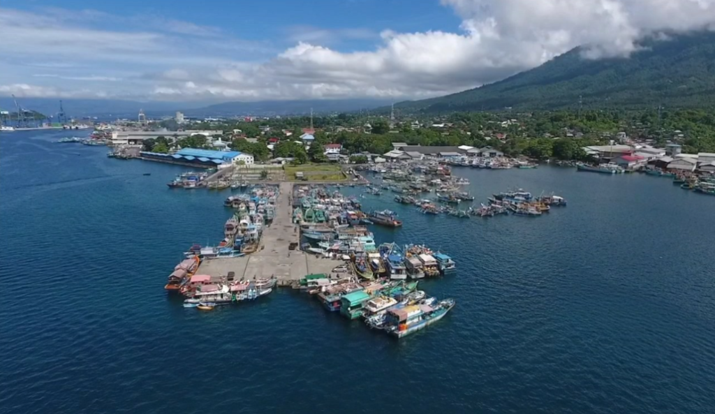
Kendari Maritime Cluster and the Ocean Fishing Port
The Kendari Ocean Fishing Port, known as PPS Kendari, is one of Indonesia's designated national-scale fishing port facilities and serves as the primary marine catch landing, processing, and distribution hub for Southeast Sulawesi's commercial fisheries sector.
The port handles tuna and other high-value pelagic species caught in the Banda Sea and surrounding waters, with cold storage, processing facilities, and direct export logistics infrastructure concentrated within the port complex.
The maritime cluster surrounding PPS Kendari includes boat repair yards, ice supply operations, net and gear suppliers, and the support services sustaining both artisanal and industrial fishing fleets operating from the city's waterfront.
The port's national designation reflects the volume and economic value of catch handled annually, and PPS Kendari has been a focus of government investment in cold chain improvement and export certification capacity to raise the value captured by Southeast Sulawesi's fishing communities.
Haluoleo Airport and Bungkutoko Port as Gateway Infrastructure
Haluoleo Airport serves Kendari City's air connectivity needs, operating scheduled domestic routes to Makassar, Jakarta, Surabaya, and other Indonesian urban centers. The airport is located outside the city's central subdistricts, connected by a main arterial road that also handles freight movement between the airport cargo facility and Kendari's commercial zone.
Runway and terminal capacity upgrades have been periodic subjects of provincial infrastructure planning discussions as passenger demand grows alongside Southeast Sulawesi's mining and government sector expansion.
Bungkutoko Port handles general cargo, bulk commodity exports including nickel ore and Buton asphalt, and passenger ferry operations connecting Kendari to Buton Island, Muna, and inter-island routes across Eastern Indonesia.
The combination of Haluoleo Airport and Bungkutoko Port creates a dual-gateway access structure that positions Kendari as a multimodal logistics node capable of handling both time-sensitive passenger and high-volume commodity freight flows across the province's island and mainland geography.
Trans-Southeast Sulawesi Corridor and Overland Freight Patterns
The main arterial road network of Southeast Sulawesi converges on Kendari City, making it the apex of the province's overland logistics system. Routes connecting Kendari to Kolaka in the west, Konawe in the north, and the coastal regencies to the south carry a heavy freight mix dominated by nickel ore haulage, agricultural commodity movement, and construction material distribution.
The corridor's condition directly affects the operational cost structure of mining companies and the competitiveness of agricultural producers in reaching the provincial capital's market infrastructure.
Road investment along the Trans-Southeast Sulawesi corridor has been integrated into national connectivity programs under Indonesia's infrastructure development agenda, with bridge reinforcement and road widening projects targeting the highest-traffic segments between mining production zones and port export facilities.
The corridor also functions as the primary route for consumer goods distribution from Kendari's wholesale market into surrounding regencies, making its operational reliability a determinant of price stability and supply security across Southeast Sulawesi's non-urban population centers.
Kekandari Metropolitan Projection and the Pacific Maritime Economy
The Kekandari metropolitan development concept frames Kendari City as the core of an integrated urban region encompassing adjacent regencies within a coordinated spatial planning framework. The projection targets population consolidation, industrial zone development, and port capacity expansion as the three structural pillars of metropolitan growth.
Provincial and national planners have positioned Kekandari as a model for managed urbanization in Eastern Indonesia, where resource extraction economies require urban service infrastructure capable of absorbing workforce concentration and corporate investment simultaneously.
Kendari's orientation toward the Pacific maritime economy reflects its geographic position on Sulawesi's eastern coast, facing the Banda Sea and within the broader trade corridor connecting Eastern Indonesia to Pacific basin markets.
As Indonesia intensifies its engagement with Pacific regional economic frameworks and as the IKN development in East Kalimantan generates new cross-island logistics demand, Kendari City's role as a supply and transit node within this eastern maritime network is expected to grow alongside the province's mineral export volumes and fisheries sector output.