

Gorontalo City sits on the northern coast of the Minahasa Peninsula, facing Tomini Bay to the south and the Celebes Sea corridor to the north, at coordinates 0°32′N and 123°3′E, at approximately 6 meters above sea level. The city covers 64.79 square kilometers divided into six districts: Kota Barat, Kota Selatan, Kota Tengah, Kota Timur, Kota Utara, and Dungingi, serving simultaneously as the capital of Gorontalo Province and the administrative center of Gorontalo Regency. Its mid-2024 population reaches approximately 210,000 residents, concentrated in a compact coastal urban zone where the Bone and Bolango Rivers converge before entering the bay.
Gorontalo City functions as the primary commercial, governmental, and educational hub for a province that stretches 11,257 square kilometers across the northern Sulawesi peninsula, anchoring the regional supply chain for corn, tuna, coconut oil, and Karawo textiles.
The Hulontalo Kingdom, Five Pohala'a, and the Road to Becoming an Independent Province
The origins of this City trace to approximately 1385, when seventeen smaller chiefdoms and clan-based communities called linula unified to form the foundational Kingdom of Gorontalo, then known as Hulontalo. The name Gorontalo itself is a Dutch phonetic adaptation of the indigenous endonym Hulontalo, a pronunciation shift introduced during colonial administration that eventually replaced the original form in official usage.
The unification of these seventeen entities established a governance structure based on communal councils called Buatulo Toulongo, which balanced monarchical authority with collective decision-making through clan representation.
The five Pohala'a — Gorontalo, Limboto, Suwawa, Boalemo, and Atinggola formed the political federation known as Duluwo Limo lo Pohala'a, first consolidated in 1481 through the merger of the Hulontalo and Limboto polities. Each Pohala'a represented a distinct ethnic and territorial unit bound to the others through kinship obligations, mutual defense arrangements, and shared adat law.
The federation operated under the cultural principle "Adat bersendikan Syara, Syara bersendikan Kitabullah" customs grounded in Islamic law, Islamic law grounded in the Quran a framework established after Islam became the official religion of the Gorontalo Kingdom under King Matolodulakiki following its introduction through Sultan Amai's marriage to an Islamic princess in 1525.
On 23 January 1942, the people of this city under H. Nani Wartabone declared independence from Dutch colonial authority, making Gorontalo one of the few regions in Indonesia to precede the 1945 national proclamation with its own sovereign act. Gorontalo remained a self-governing territory for approximately two years before Japanese occupation.
After independence, the region was incorporated into North Sulawesi Province until 5 December 2000, when Gorontalo became Indonesia's 32nd province under Law No. 38 of 2000, restoring the political autonomy that the Pohala'a federation had maintained for centuries.
Hulontalo Identity, the Gorontalo Tribe, and the Cultural Character of the City
The City people, also called Hulontalo, form the dominant indigenous ethnic group in the city, tracing their identity through the Pohala'a lineage system that structured social organization before, during, and after the sultanate period. The ethnic Gorontalo community encompasses sub-groups including the Hulontalo, Suwawa, Bolango, Atinggola, and Limutu, each associated with specific territorial origins within the province while sharing a common language, adat framework, and Islamic identity.
Javanese, Bugis, and Chinese-Indonesian communities contribute to the city's commercial and demographic mix through historical trade networks and colonial-era settlement patterns.
The cultural identity of the City carries an explicitly Islamic character that earned the city its most recognized title: Serambi Madinah, the Veranda of Medina. This designation reflects a level of Islamic integration into daily life, governance, and custom that goes beyond nominal religious affiliation.
Adat council system inherited from the Pohala'a federation continues to mediate community disputes alongside formal government institutions. Traditional performance arts including the Langga dance and the Polopalo bamboo musical instrument remain active expressions of Hulontalo cultural distinctiveness within the city's ceremonial and festival calendar.
How the Gorontalo Dialect Works and Why "Ti" Carries Daily Social Weight
The Gorontalo language belongs to the Austronesian family and represents one of the larger indigenous languages of Sulawesi, spoken natively by approximately 900,000 people across the province and diaspora communities throughout Indonesia. The language carries a phonological structure distinct from Malay-based languages, with tonal patterns, consonant clusters, and a vocabulary built from centuries of trade contact with Ternate, Tidore, Malay, Arabic, and Portuguese traders along the Tomini Bay maritime corridor.
In this City, the language functions alongside standard Indonesian, with the local dialect used in household, community, and market settings while Indonesian dominates formal education and government.
The particle "Ti" functions as one of the most frequently used and socially significant elements in the Gorontalo dialect, operating as a personal article placed before proper names and carrying respectful or affectionate social framing depending on context and intonation.
Its usage identifies speakers as native Gorontalo-language users rather than Indonesian-dominant speakers, functioning as a subtle linguistic identity marker in urban settings where the two languages coexist.
The particle has no direct equivalent in standard Indonesian and represents one of the grammatical features that most clearly distinguishes Gorontalo speech patterns from the national language in everyday urban conversation.
Tower of Majesty, Saronde Monument, and Baiturrahim Mosque as Landmark Anchors
The Tower of Majesty Menara Keagungan stands as Gorontalo City's primary modern civic landmark, designed with architectural elements referencing the Islamic and Pohala'a cultural heritage of the province. Its position within the city's institutional zone aligns it with the provincial government complex and functions as the visual reference point for the administrative center.
The Saronde Monument commemorates the spirit of Gorontalo's archipelagic identity, referencing Saronde Island off the northern coast as a symbol of the province's maritime heritage and natural beauty.
The Baiturrahim Mosque serves as one of Gorontalo City's principal religious landmarks, operating within the urban fabric as both a place of worship and an architectural expression of the city's Serambi Madinah identity.
The mosque's architectural language combines Islamic structural forms with local design vocabulary, occupying a central position in the city's social geography that reflects the integration of religious practice into daily civic life that characterizes Gorontalo's cultural framework.
The three landmarks collectively define the symbolic axis of a city whose identity is simultaneously historical, maritime, and Islamic.
Otanaha Fort, Botubarani Whale Sharks, and the 2000 Steps Trail
Otanaha Fortress was built in 1522 by King Ilato of the Gorontalo Kingdom with technical assistance from Portuguese sailors, constructed on Dembe Hill using a mortar mixture of sand, calcium, and Maleo bird eggs. The fort consists of three connected structures Otanaha, Otahiya, and Ulupahu Palace positioned at successive elevations on the hillside overlooking Lake Limboto and Gorontalo City.
Reaching the main fort requires ascending 348 stone steps divided across four rest points, a climb that delivers panoramic views over the lake, the city, and the Tomini Bay horizon.
The fortress is the most historically significant pre-colonial structure in Gorontalo Province and provides the clearest physical evidence of the Gorontalo Kingdom's defensive and political organization during the Portuguese contact period.
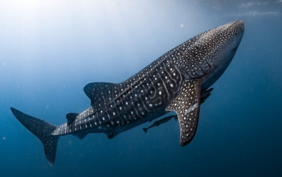
Botubarani Village in the Bone Pantai subdistrict, approximately 30 minutes from Gorontalo City, hosts one of Indonesia's most accessible whale shark encounters. The whale sharks — ranging from 9 to 12 meters in length — regularly approach the village's nearshore waters, historically attracted by effluent from a prawn processing plant nearby.
Visitors access the sharks by chartered fishing boat with snorkeling equipment, with trips limited to four people per boat to manage ecological impact.
The seasonal pattern peaks between November and May, drawing domestic and international wildlife tourists who use Gorontalo City as their base. The 2000 Steps trail in the city's hill terrain offers a distinct outdoor exercise and viewpoint destination for local residents and visitors seeking urban elevation access.
Citimall Gorontalo, Modern Retail, and the Urban Lifestyle Center
Citimall Gorontalo functions as the city's primary modern indoor retail and entertainment destination, housing national retail brand tenants, a food court, cinema facilities, and family leisure operators in a single air-conditioned complex accessible to both city residents and visitors from surrounding regencies.
Its development reflects the maturation of Gorontalo City's middle-class consumer economy following provincial capital status and the population growth that accompanied decentralization-era government expansion.
The urban lifestyle center around Citimall and the broader Kota Tengah commercial district generates a cafe culture and evening economy that operates distinctly from the traditional market activity around Pasar Sentral.
Independent coffee shops and food and beverage operators have expanded across the commercial corridor connecting the mall zone to the riverfront area, serving a young professional and student population generated by the concentration of government offices, Gorontalo State University, and vocational education institutions within the city.
Karawo Cloth and Upiah Karanji as Creative Industry Pillars
Karawo is Gorontalo's signature handcraft textile, produced through a meticulous process of drawing threads from woven fabric and filling the resulting grid with embroidered colored thread in floral, geometric, and figurative patterns. The technique is classified among Indonesia's most labor-intensive textile traditions, requiring significant production time per piece depending on pattern density and fabric scale.
The name Karawo derives from the Gorontalo language and the craft is recognized as an Intangible Cultural Heritage of Indonesia. Production workshops concentrate in the Limba B district of Gorontalo City, where artisan households have maintained the craft across generations.
Karawo cloth is sold as finished garments, fabric lengths, and fashion accessories, feeding both the domestic souvenir economy and the growing premium textile export market for distinctive Indonesian handcraft textiles.
Upiah Karanji is the traditional Gorontalo skullcap, produced through rattan or pandanus weaving into a firm, rounded cap form worn by men during religious ceremonies, adat events, and formal Gorontalo cultural occasions.
The craft carries deep identity significance within the Hulontalo cultural framework, where the skullcap functions as a visual marker of cultural affiliation and religious practice simultaneously.
The combination of Karawo cloth and Upiah Karanji production positions Gorontalo City's creative industry sector as a culturally grounded economic segment that connects contemporary fashion markets to a centuries-old material culture tradition.
Macro Corn, Coconut Oil, and Tuna from Tomini Bay as Commodity Foundations
Gorontalo Province produces the largest share of corn per capita among Indonesian provinces, with the crop dominating the agricultural landscape across the coastal lowlands and hill terrain surrounding this City.
The city functions as the primary trading, milling, and distribution hub for provincial corn output, with commodity brokerages and feed mill operators concentrated in the commercial district routing production toward livestock feed markets in Java and Sulawesi and toward export channels through Gorontalo Port.
The corn economy defines the visual character of the province's agricultural zones and the commodity flow through the city's logistics infrastructure.
Coconut oil processing connects the province's extensive coconut cultivation in the coastal regencies to food manufacturing and cosmetic ingredient export markets, with this City hosting the distribution and export coordination functions for this supply chain.
Tuna from Tomini Bay represents the highest-value fisheries commodity in the provincial economy, with the bay's warm deep waters supporting yellowfin and bigeye tuna populations that sustain both artisanal fishing communities along the shoreline and commercial longline operations.
The Fish Landing Port Tenda on the Gorontalo City waterfront processes a significant portion of this catch for the domestic and export markets.
Binte Biluhuta, Ayam Iloni, and Sabongi Cake as Culinary Identity
Binte Biluhuta is the most recognized traditional dish of Gorontalo City, built on a corn soup base combined with skipjack tuna or shrimp, grated coconut, basil, spring onion, and lime in a clear broth. The name translates roughly as "corn splashed with water," describing the visual character of the corn kernels floating in the aromatic broth.
The dish represents the agricultural and maritime identity of Gorontalo simultaneously, connecting the province's corn production economy to its Tomini Bay fisheries in a single bowl.
It is served across warungs, restaurants, and market stalls throughout the city and functions as the culinary signature by which Gorontalo identifies itself to visitors from other provinces.
Ayam Iloni is a grilled chicken preparation unique to Gorontalo, marinated in a spice mixture that includes coconut milk, turmeric, galangal, and local aromatics before being grilled over charcoal until the exterior caramelizes. The coconut milk base produces a distinctive flavor profile that distinguishes it from equivalent grilled chicken preparations in Java or Sumatra.
Sabongi cake is a traditional Gorontalo sweet made from glutinous rice flour and coconut sugar, steamed in bamboo or wrapped in banana leaf in cylindrical form, with a dense, chewy texture and a naturally sweet coconut flavor that places it within the same confectionery family as similar steamed rice cakes found across the eastern Indonesian archipelago.

Corporate Landscape, Banking Sector, and Distribution Centers
Gorontalo City hosts the regional offices and branch operations of agricultural trading companies, commodity exporters, and construction contractors serving both the provincial government's infrastructure program and the commercial agricultural economy. The corn commodity chain alone generates a network of input suppliers, warehouse operators, and trading firms operating from Gorontalo City toward production zones across the province.
Distribution center operations serving the province's retail and food service markets concentrate in the commercial district between Pasar Sentral and the port corridor, routing consumer goods from Manado, Makassar, and Surabaya supply chains into Gorontalo's urban and rural retail network.
The national state bank network including BRI, BNI, Bank Mandiri, and BTN maintains full branch coverage across the city, with Bank Pembangunan Daerah Gorontalo providing regional development lending to agricultural smallholders, fisheries operators, and SME businesses.
The banking sector's concentration in Gorontalo City reflects the city's role as the financial intermediary between provincial commodity production and the formal credit system, channeling agricultural loans to corn and coconut farmers through cooperative and individual lending programs across all five regencies.
Tenda Fish Landing Port, Maritime Cluster, and the Fishing Economy
The PPI Tenda — Pangkalan Pendaratan Ikan Tenda functions as Gorontalo City's primary fish landing and processing hub, situated on the city's southern waterfront where the Bone River meets Tomini Bay. The facility handles daily catch from both inshore artisanal fishing boats operating within the bay and from commercial vessels making longer hauls across the deeper Tomini Bay tuna grounds.
The landing port generates morning market activity involving direct sales of fresh tuna, skipjack, red snapper, and reef fish to local traders, restaurant operators, and ice-box wholesalers who distribute catch to markets across the province.
The broader maritime cluster along the Gorontalo City waterfront includes the Gorontalo Port ferry terminal serving inter-island passenger routes to Pagimana, Ampana, and the Togean Islands in Central Sulawesi, as well as cargo services handling provincial import and export commodity movements.
The ferry connection to the Togean Islands positions Gorontalo City as the primary departure point for one of Sulawesi's most sought-after eco-tourism archipelago destinations, adding a tourism logistics dimension to the port's commercial and fisheries functions.
Djalaluddin Airport and Gorontalo Port as Primary Connectivity Infrastructure
Djalaluddin Airport carries IATA code GTO and is located in Tolangohula, Gorontalo Regency, approximately 36 kilometers from Gorontalo City center. The airport is named after Mayor Udara Djalaluddin Tantu, an Indonesian Air Force officer from Gorontalo who served during the national revolution period.
Regular scheduled services connect Gorontalo City to Jakarta via Makassar on Garuda Indonesia, Lion Air, and Batik Air, with connections to Manado, Ternate, and other eastern Indonesian destinations through code-share and connecting flight arrangements.
The airport serves as the primary air gateway for both incoming visitors heading to the Botubarani whale shark encounter and the Togean Islands circuit, as well as for outgoing commodity and passenger flows connecting the province to the national air network.
Gorontalo Port in the city center handles the PELNI inter-island passenger ship network connecting Gorontalo to Bitung, Makassar, Surabaya, and other major Indonesian ports, as well as roll-on roll-off ferry services and the smaller fast boat and ferry routes to Central Sulawesi's coastal communities across Tomini Bay.
Trans-Sulawesi Corridor, Cross-Strait Integration, and the Greater Gorontalo Projection
The Trans-Sulawesi Road North Corridor connects Gorontalo City to Manado in North Sulawesi to the east and to Palu in Central Sulawesi to the west, running along the northern peninsula's coastal terrain as the primary overland logistics artery for inter-provincial commodity and passenger movement.
The road connects Gorontalo's agricultural hinterland to the Bitung export port in North Sulawesi and to the Makassar-oriented logistics chain through Central Sulawesi, making it the structural backbone of the province's land-based supply chain integration.
The cross-strait economic integration framework for Gorontalo City centers on the Tomini Bay corridor connecting the northern Sulawesi coast to the Central Sulawesi shore, a maritime trade route that has historically linked Gorontalo's commodity economy to the Bajo fishing communities, the Togean Islands, and the agricultural zones of Tojo Una-Una and Morowali Regencies across the bay.
Greater Gorontalo projections in regional planning frameworks incorporate the Bone Bolango and Gorontalo Regency peripheral zones into a wider metropolitan planning area that would absorb the demographic and economic growth generated by provincial capital functions, infrastructure expansion, and the continued development of the tuna and corn commodity export chains that underpin the provincial economy as its primary long-term growth drivers.