
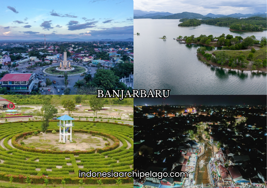
Banjarbaru City sits at the foot of the Meratus Mountains in South Kalimantan Province at coordinates 3°26′32″S and 114°45′45″E, positioned between Banjar Regency to the north, east, and west, and Tanah Laut Regency to the south. The city covers approximately 371.38 square kilometers with 80 percent of its terrain elevated between 0 and 25 meters above sea level, with podzol soil dominating 63.82 percent of the land surface.
On 15 February 2022, Banjarbaru City was formally designated the provincial capital of South Kalimantan under Law No. 8 of 2022, completing a transition that had been planned since the 1950s. Administratively it divides into five districts: Landasan Ulin, Liang Anggang, Cempaka, Banjarbaru Utara, and Banjarbaru Selatan, with the mid-2024 population estimated at 280,826 residents.
Van der Pijl's Colonial Blueprint and the Long Road to Official Provincial Capital
Banjarbaru City's existence traces to a deliberate planning decision made during the final years of Dutch colonial administration in Kalimantan. Dutch architect D.A.W. Van der Pijl developed the city's master plan in 1953, working from a European garden city concept that prioritized city parks, wide civic axes, and a city hall at the urban center.
The original intent was ambitious: Banjarbaru was designed to replace Banjarmasin as the capital of the unified Kalimantan province, a response to Banjarmasin's chronic flooding and overcrowding. The plan carried the imprint of European functionalism, with symmetrical street grids, civic green spaces, and institutional building clusters that remain partly visible in the city's layout today.
The capital relocation plan was canceled before full implementation as Kalimantan was divided into separate provinces, leaving Banjarbaru as a partially built planned city without its intended administrative role. Governor Murdjani had already begun advocating for capital relocation during his 1950 to 1953 term, and the idea persisted across successive administrations.
Banjarbaru received administrative city status in 1975 and full municipal status on 20 April 1999 through Law No. 9 of 1999. Provincial government functions began shifting to Banjarbaru from Banjarmasin in August 2011, and the formal legal designation as South Kalimantan's capital came through Parliament on 15 February 2022, closing seven decades of deferred planning intent.
Banjar Majority Identity and the Urban Heterogeneity of a Planned City
The Banjar ethnic group constitutes the dominant cultural presence in Banjarbaru City, bringing with it a strong Islamic identity, a merchant trading tradition rooted in the historic Banjar Sultanate, and a distinctive material culture expressed through textiles, cuisine, and ceremonial practice. Javanese transmigrant communities represent the second significant ethnic presence, concentrated in agricultural and urban labor sectors.
Bugis migrants, Dayak communities from the interior, and Chinese-Indonesian traders contribute to an ethnic mix that reflects Banjarbaru's position as a planned administrative city that attracted diverse populations during its accelerated development period.
The Banjar cultural framework operates through a social structure where Islamic scholars, traditional merchants, and adat leaders hold parallel authority alongside formal government institutions.
Communal ceremonies including Baayun Mulud, which involves swinging infants in ceremonial hammocks during the Prophet Muhammad's birthday observance, and the Batamat Al-Quran graduation ceremony for young Quran readers, punctuate the social calendar across Banjarbaru's Banjar neighborhoods.
The city's identity as "Idaman" an acronym for Indah, Dinamis, Agamais, Mandiri, and Nyaman reflects a civic branding effort to frame its multicultural population around shared values of beauty, dynamism, and religious moderation.
Banjar Kuala Dialect and the Everyday Slang of Banjarbaru Streets
The Banjar language divides into two primary dialect streams: Banjar Hulu, spoken in interior highland communities near the Meratus Mountains, and Banjar Kuala, the coastal and lowland variant that dominates Banjarbaru City and the wider provincial capital corridor.
Banjar Kuala carries phonological softness compared to its interior counterpart, with flatter vowel tones and a higher absorption rate of Arabic loanwords reflecting the coastal trading community's centuries of contact with Arab, Malay, and Javanese linguistic influences.
In Banjarbaru City's urban setting, Banjar Kuala functions as the primary community language in markets, mosques, and household settings, while standard Indonesian dominates formal education and government administration.
Street-level slang across Banjarbaru draws from Banjar Kuala's phonological patterns, with commonly used address forms and conversational particles that signal local belonging across ethnic lines.
The term "Ulun" meaning "I" or "me" in respectful Banjar usage appears frequently in daily speech as a marker of social humility and cultural affiliation, used by Banjar and non-Banjar urban residents alike as a form of linguistic integration into the city's dominant social register.
Murjani Field, the Provincial Government Complex, and the City's Landmark Axis
Lapangan Murjani named after Governor Murdjani, the early advocate for the capital relocation functions as the primary civic open space and ceremonial ground in Banjarbaru City's center. The field hosts flag ceremonies, national holiday celebrations, and public events that anchor the city's institutional identity.
Its position adjacent to the main government buildings reflects Van der Pijl's original planning intent for a civic plaza at the urban core, one of the few elements of the Dutch master plan that survived the cancellation of the full relocation scheme.
The South Kalimantan Provincial Government Office Complex concentrates the executive and legislative administration buildings of the province in a dedicated institutional zone in Banjarbaru City.
The complex was built progressively as provincial functions transferred from Banjarmasin between 2011 and 2022, with the governor's office, provincial legislature, and supporting agencies occupying a campus-style arrangement that gives the eastern side of the city its administrative character.
Together, Lapangan Murjani and the government complex define a civic axis that distinguishes Banjarbaru's center from the commercial corridors closer to Syamsudin Noor Airport to the west.
Rainbow Village, Seran Lake, and Cempaka Diamond Mining as Tourist Reference Points
Rainbow Village in Banjarbaru City is a community-based tourism destination where residential houses along a neighborhood corridor are painted in saturated multicolored patterns, producing a visual attraction that has drawn significant domestic visitor traffic since its development as a social media-oriented tourism object.
The concept follows similar colored village initiatives across Indonesian cities and has become an accessible, low-cost urban tourism stop for visitors using Banjarbaru as a base for regional exploration.
Seran Lake provides a natural water recreation destination within the city's accessible radius, with fishing activity, boat rental, and lakeside food stall operations catering to weekend visitors from Banjarbaru and Banjarmasin.
The Cempaka diamond mine in the Cempaka District, approximately 10 kilometers from the city center, operates as one of the few remaining traditional alluvial diamond mining sites accessible to tourists anywhere in the world.
Local miners use manual dulang panning technique to wash river sediment in search of diamonds, yellow sapphires, and other precious stones. The site connects directly to the regional gemstone economy centered in nearby Martapura, forming a tourism circuit that combines extractive heritage with the polished gem retail market.

Modern Shopping Centers, Academic Cafe Culture, and the Urban Leisure Economy
Banjarbaru City has developed a contemporary retail infrastructure anchored by large shopping centers including Duta Mall Banjarbaru and Q Mall Banjarbaru, which serve both city residents and the wider Banjarbakula metropolitan population that uses Banjarbaru's commercial corridor as its primary urban retail destination.
The proximity of Syamsudin Noor Airport and the presence of multiple university campuses including Lambung Mangkurat University generate sustained retail and food service demand across the city's commercial zones.
The academic cafe culture has grown into a defining feature of Banjarbaru's urban character, driven by the large student population from its university and vocational education cluster.
Independent cafes and coffee shop chains concentrate around the Guntung Payung and Banjarbaru Utara corridors, operating as study, coworking, and social gathering spaces. This cafe economy feeds directly on South Kalimantan's robusta coffee supply chain while generating a hospitality sector segment that operates independently of commodity price cycles.
Sasirangan Embroidery and Martapura Gemstone Trade as Creative Industry Pillars
Sasirangan is the traditional textile of the Banjar ethnic group, produced through a barrier-resist dyeing method where the artist hand-stitches patterns onto cloth with string or yarn before immersing the fabric in natural or synthetic dyes. The name derives from the Banjar word "sirang" meaning "to stitch together," which describes the central technical step that creates the characteristic layered pattern.
Unlike Javanese batik, Sasirangan uses thread rather than wax as its resist barrier, producing a sharper edge definition and a textile character that is visually distinct from other Indonesian tie-dye traditions. Banjarbaru City functions as a primary retail distribution point for Sasirangan cloth, with craft shops and market stalls serving both domestic souvenir buyers and inter-island wholesale traders.
The Martapura gemstone trade, centered in the adjacent Banjar Regency town of Martapura and accessible within 15 minutes from Banjarbaru City, constitutes one of the most economically significant creative and craft industry clusters in Indonesian Borneo.
Martapura's Cahaya Bumi Selamat market concentrates hundreds of gemstone retailers and jewelry workshops selling diamonds, yellow sapphires, amethysts, and garnets sourced from the Cempaka alluvial deposits and other South Kalimantan mineral zones.
Banjarbaru City serves as the logistics and accommodation base for gemstone buyers arriving at Syamsudin Noor Airport before traveling to Martapura, embedding the gemstone trade circuit into the city's broader commercial economy.
Quartz Sand, Precious Stones, and Horticultural Agribusiness as Commodity Foundations
Quartz sand extraction from the Meratus Mountain foothills surrounding Banjarbaru City supplies construction material markets across South Kalimantan and serves as a raw material input for the regional glass and ceramics manufacturing supply chain. The geological formation at the city's eastern edge produces consistently high-purity quartz deposits that command premium pricing over the lower-grade riverbed sand available across lowland Kalimantan.
Precious stone production from the Cempaka District connects to the Martapura jewelry processing industry, with raw diamond and colored stone output feeding a polishing and retail chain that generates employment across hundreds of artisan workshops.
Horticultural agribusiness operates across Banjarbaru's peripheral districts, with smallholder vegetable farms, fruit orchards, and ornamental plant nurseries concentrated in the Banjarbaru Selatan and Cempaka areas.
The elevated terrain and podzol soil conditions, while limiting for large-scale monoculture, support diverse smallholder production of vegetables and tropical fruits that supply the city's fresh produce market and the broader Banjarbakula metropolitan food chain.
The ornamental plant sector has grown alongside the city's rapid urbanization, supplying landscaping demand from government building projects and the expanding residential development zones connected to the Aerocity planning corridor.
Swike Cempaka, Nasi Samin, and Bingka Barandam as Culinary Identity
Swike Cempaka is the signature dish associated with the Cempaka district, built on a frog-based protein preparation tradition that reflects the wetland and agricultural ecology of the lowland areas surrounding the diamond mining zone. The dish is prepared with aromatics and spice blends that characterize the Banjar cooking tradition, served across specialist warungs in the Cempaka area.
Nasi Samin is a fragrant rice preparation cooked with clarified butter, spices, and rosewater that carries Arabic culinary lineage through the Banjar trading community's centuries of contact with Middle Eastern merchants via the Malacca Strait trade network. It is served at ceremonial meals, wedding feasts, and Islamic communal gatherings across Banjarbaru City.
Bingka Barandam is a soft, sweet traditional cake produced from a batter of flour, coconut milk, eggs, and sugar baked in a banana leaf mold. The "barandam" reference in the name describes the soaking or submersion method associated with some preparation variants.
The cake functions as both a household staple and a packaged souvenir product sold across Banjarbaru's traditional markets and airport retail outlets, representing the Banjar confectionery tradition alongside similar coconut-milk cake forms found across South Kalimantan.

Corporate Landscape, Banking Sector, and Regional Logistics Hubs
Banjarbaru City hosts the operational and administrative offices of plantation companies, mining contractors, and construction firms active across South Kalimantan's resource extraction corridor. The city's elevation to provincial capital in 2022 accelerated corporate relocation decisions, with companies requiring proximity to the provincial government bureaucracy establishing offices in Banjarbaru's commercial district rather than maintaining their previous Banjarmasin base.
National state bank branches including BRI, BNI, Bank Mandiri, and BTN maintain full presence alongside Bank Kalsel, the regional development bank that finances agricultural and SME operations across the province's fourteen regencies and two cities.
Logistics hub development in Banjarbaru City reflects its position on the primary overland route connecting Banjarmasin's Trisakti Port to the Trans-Kalimantan highway network. Warehousing, freight forwarding, and cold chain logistics operators have established facilities along the Landasan Ulin corridor adjacent to the airport, capitalizing on dual air-road access points that no other location in South Kalimantan can offer within a single district boundary.
Liang Anggang Maritime Cluster and Land Port Access
The Liang Anggang district in Banjarbaru City functions as the designated logistics and land transport node within the Aerocity development framework covering approximately 7,216 hectares across Landasan Ulin and Liang Anggang. The district sits on the southern corridor connecting Banjarbaru to the Tanah Laut coast, positioning it as a land port access zone for freight moving between the city's industrial and warehousing cluster and the South Kalimantan coastal maritime network.
The Terminal Liang Anggang serves inter-city passenger bus routes and regional freight vehicle operations, functioning as the primary land transport interchange for cargo and passengers using the southern corridor out of Banjarbaru.
The maritime cluster character of the Liang Anggang corridor derives from its role in the logistics chain connecting interior commodity producers to coastal export facilities. Palm oil, rubber, and construction material flows from the surrounding regencies transit through the Liang Anggang zone before connecting to Banjarmasin's Trisakti Port or to the coastal facilities at Tanah Laut Regency's Pelaihari corridor.
The Aerocity master plan projects Liang Anggang as a new logistics and warehousing center with medium-to-high density residential development, catalyzed by the airport's passenger volume and the corridor's position within the Banjarbakula National Strategic Area.
Syamsudin Noor International Airport as the City's Primary Connectivity Node
Syamsudin Noor International Airport carries IATA code BDJ and is located in the Landasan Ulin district, 5 kilometers west of Banjarbaru City's center and approximately 25 kilometers southeast of Banjarmasin. The airport began operations in 1936 as Lapangan Terbang Ulin before receiving civil airport designation in 1975 and its current name honoring South Kalimantan Air Force officer Syamsudin Noor.
The terminal complex covers 77,562 square meters with capacity to handle 7 million passengers annually, accommodating wide-body aircraft including the Airbus A330-300, Boeing 747-400, and Boeing 787 Dreamliner at the main terminal while a secondary terminal handles medium-range Boeing 737 series operations.
The 2024 statistics recorded 3,132,529 passenger movements, 33,045 tonnes of cargo, and 26,741 aircraft movements, connecting Banjarbaru and Banjarmasin to Jakarta, Surabaya, Balikpapan, Makassar, and regional Kalimantan destinations.
Banjarbakula Metropolitan Framework and the IKN Logistics Buffer Role
The Banjarbakula Metropolitan Area designates Banjarbaru City as the core urban zone of a regional metropolitan framework encompassing Banjarmasin, Banjar Regency, Barito Kuala Regency, and Tanah Laut Regency, with combined population and economic activity that positions the cluster as South Kalimantan's primary urban agglomeration.
Banjarbaru City holds PKN status (Pusat Kegiatan Nasional) recognizing its role as a national activity center serving the southern Kalimantan island region. The Aerocity concept frames the Landasan Ulin and Liang Anggang corridor as a new economic growth center built around airport-anchored logistics, warehousing, trade, and hospitality.
The Indonesian capital city Nusantara in East Kalimantan sits approximately 380 kilometers northeast of Banjarbaru City by road. Indonesian government planning frameworks have formally identified Banjarbaru City as a projected main buffer for IKN logistics supply chain operations, leveraging its Syamsudin Noor Airport cargo capacity, Trans-Kalimantan highway access, and provincial capital administrative infrastructure as complementary nodes to IKN's own logistics network.
The Trans-Kalimantan road axis connecting Banjarbaru through Banjarmasin and northward toward Palangkaraya and the East Kalimantan border forms the primary overland logistics spine through which construction materials, government supplies, and workforce movement for IKN development routes through South Kalimantan, placing Banjarbaru City at a structurally significant intersection point in the national capital project's supply geography.