
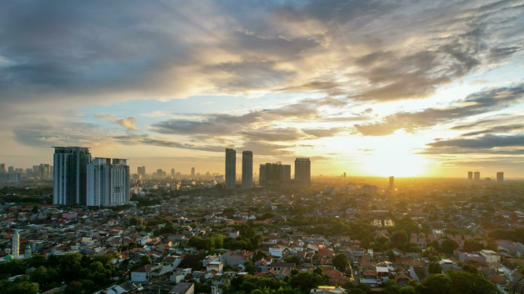
Jakarta Metropolis consistently holds first place nationally as the province with the highest population density in Indonesia, a distinction that has shaped every layer of its urban design, economic output, and cultural identity. With over 10,000 people per square kilometer in its core districts.
Jakarta is not merely a capital city — it functions as the primary engine of the entire archipelago's financial and administrative activity. Understanding this city requires moving beyond its traffic reputation and into its structural logic, its neighborhoods, its hidden geography, and the industries that anchor it to global networks.
Why Jakarta Leads Indonesia in Population Density
Jakarta's position at the top of Indonesia's density rankings is not accidental. The city sits at the convergence of Java's western economic corridor, the Java Sea maritime route, and decades of centralized national policy that directed infrastructure investment into one metropolitan core. The historical concentration of government institutions, banking headquarters, and logistics infrastructure created a self-reinforcing pull for internal migration from across the archipelago.
At its peak density periods, the city absorbs roughly 1.3 million commuters daily from surrounding Bodetabek zones — Bogor, Depok, Tangerang, and Bekasi — swelling the effective daytime population well past its registered figure. This dual-population dynamic is one reason why Jakarta's urban planning frameworks have consistently struggled to match infrastructure supply with demand.
The land area of 662 square kilometers supports a registered population exceeding 10 million, placing pressure on water, waste management, and green space at a scale few Asian cities have matched.
Jakarta Metropolis Regional Division and the Strategic Logic Behind It
Jakarta is formally divided into five administrative municipalities and one regency: Central, South, North, West, East, and the Thousand Islands. Each zone carries a distinct functional character that emerged not from top-down planning alone but from the layered histories of trade, colonial infrastructure, and post-independence industrial policy.
The five mainland municipalities share administrative boundaries that often feel arbitrary at street level, yet they reflect decades of development priorities.
South Jakarta received commercial and diplomatic investment.
North Jakarta absorbed port expansion.
East Jakarta was designated an industrial corridor.
West Jakarta retained its trading-district character from the colonial era.
Central Jakarta was reserved for governmental and ceremonial infrastructure.
Understanding this zoning logic is essential for anyone working with the city's property market, logistics networks, or municipal data.
Central Jakarta: The Heart of Authority
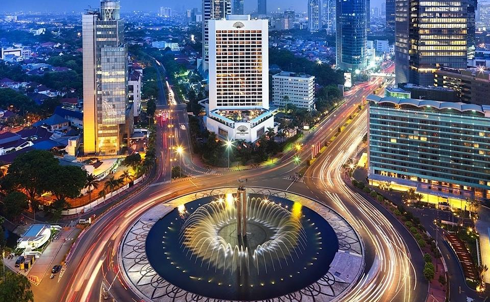
Central Jakarta holds the formal seat of Indonesian government, including the Istana Merdeka presidential complex, the Supreme Court, and the Constitutional Court. The National Monument, known as Monas, anchors the Medan Merdeka square — a deliberate civic axis designed to project state permanence.
Beyond government, Central Jakarta hosts several large-scale media conglomerates and financial regulatory bodies. The district's street grid is among the most formal in the city, reflecting its planned character under Dutch colonial administration and its subsequent reinforcement as an administrative showcase after independence.
Property values here remain among the highest per square meter in the metropolitan area, driven by land scarcity and institutional demand rather than commercial retail density.
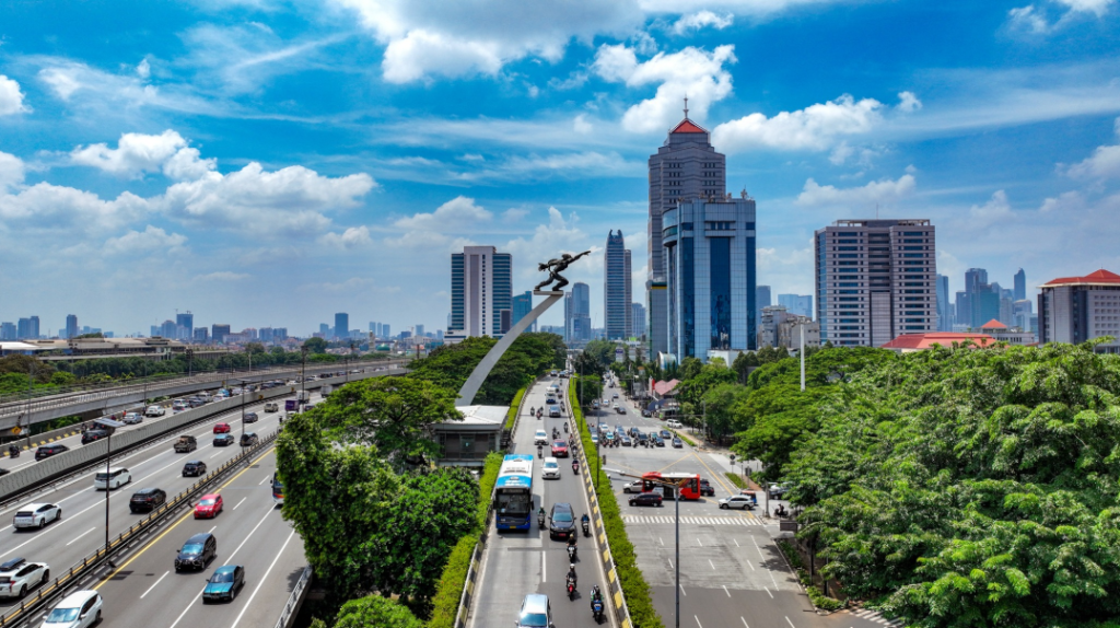
South Jakarta: The Lifestyle and Tech Hub
South Jakarta has undergone the most visible transformation of any Jakarta district over the past two decades. The Sudirman-Thamrin corridor extending into Kuningan and Gatot Subroto now concentrates the majority of Jakarta's Grade A office towers, five-star hotels, and institutional banking infrastructure.
The emergence of M Bloc Space as a creative district in Radio Dalam reflects a broader pattern of adaptive reuse in South Jakarta, converting former industrial and residential lots into mixed-use cultural anchors.
The district also hosts a significant concentration of technology startup offices and coworking infrastructure, making it the de facto tech hub of the Jakarta metropolitan area. Kemang and Senopati remain the primary lifestyle corridors, attracting regional food and beverage operators alongside international brands.
North Jakarta: The Maritime Gateway to Global Trade
North Jakarta's identity is inseparable from Tanjung Priok, the largest port in Indonesia and one of the highest-throughput cargo terminals in Southeast Asia. The port processes the majority of Indonesia's containerized import and export volume, making North Jakarta a critical node in regional supply chains.
The waterfront area retains traces of its VOC-era architecture in Kota Tua, where 17th-century Dutch warehouses have been partially converted into cultural venues and tourism anchors. Phinisi Cruise Jakarta operates from the North Jakarta waterfront, offering an access point to the harbor geography that most urban residents rarely experience at water level.
The district's industrial character is reinforced by its cold storage facilities, fuel depots, and customs infrastructure clustered around the port perimeter.
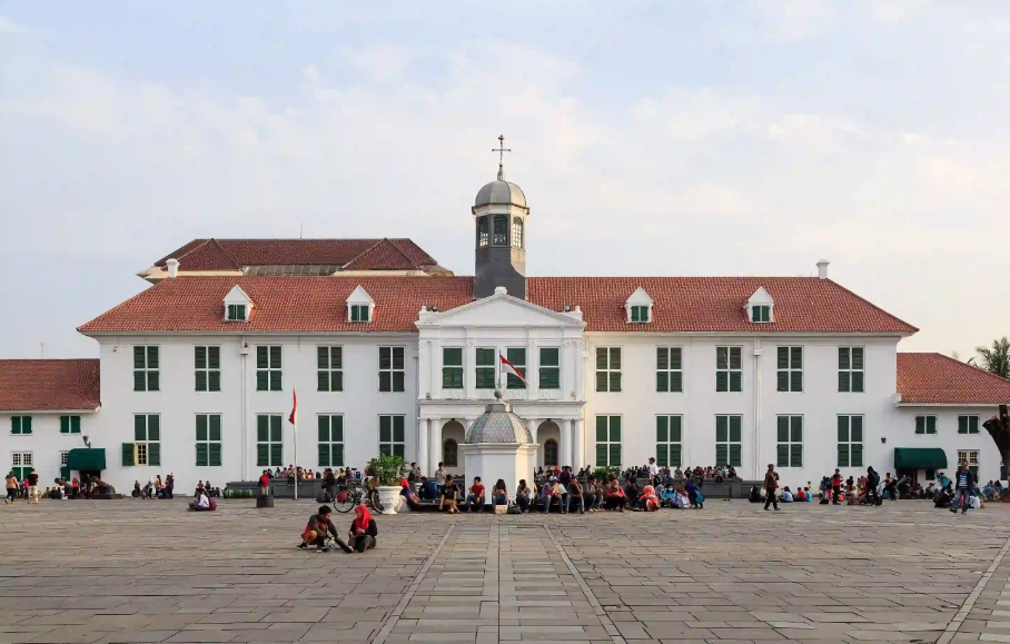
West Jakarta: The Heritage and Trade Center
West Jakarta functions as the commercial backbone of Jakarta's Chinese-Indonesian trading community, a role it has maintained since the colonial period when Glodok district served as the designated settlement zone for Chinese traders under VOC administration. The district today concentrates electronics markets, wholesale textile operations, and light manufacturing facilities.
The Kali Besar canal corridor in Kota Tua sits administratively between West and North Jakarta and represents one of the few remaining urban heritage zones where colonial-era building stock is still largely intact. Property in West Jakarta tends to prioritize commercial floor area over residential amenity, reflecting its function as a trade and logistics district rather than a lifestyle destination.
East Jakarta: The Industrial and Cultural Park
East Jakarta serves as the city's primary industrial corridor, hosting manufacturing plants, logistics warehouses, and assembly operations across Pulogadung, Cakung, and Cilincing industrial zones. The Pulogadung Industrial Estate remains one of the oldest and largest in Greater Jakarta, accommodating over 200 industrial tenants ranging from food processing to automotive components.
Alongside its industrial function, East Jakarta contains several significant cultural assets. The Taman Mini Indonesia Indah cultural park offers one of the most comprehensive surveys of Indonesian regional architecture and cultural heritage in a single site.
The district's demographic mix — industrial workers, long-established Betawi communities, and new migrant populations — gives it a cultural texture distinct from the commercial districts to the west and south.
Thousand Islands: The Natural Escape Within Reach
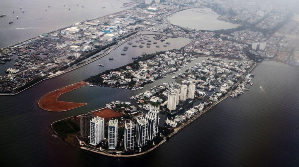
The Thousand Islands regency — Kepulauan Seribu — consists of 110 islands scattered across the Java Sea north of Jakarta, of which only a fraction are inhabited. The archipelago functions as the primary accessible natural escape for Jakarta's urban population, with day trips and weekend itineraries anchored around snorkeling, island-hopping, and marine conservation zones.
City Forest by Plataran on Pramuka Island represents the premium end of Thousand Islands accommodation, offering a managed resort environment within a designated conservation area. The regency operates under a separate administrative structure from the five mainland municipalities, reflecting its distinct geographic and ecological character. Marine biodiversity in the northern islands remains significant despite proximity to Jakarta's coastal pollution gradient.
The Betawi Soul: Culture, Tribe and Language
The Betawi people are the indigenous ethnic group of Jakarta, descended from a mix of Malay, Sundanese, Javanese, Arab, Chinese, and Portuguese populations who converged around Batavia during the colonial period. Their language, Bahasa Betawi, is a Malay-based creole incorporating lexical borrowings from Dutch, Portuguese, and Hokkien Chinese.
Despite being numerically outnumbered in their own city by migrant populations from Java and Sumatra, the Betawi retain a disproportionate cultural presence through formal heritage preservation policies and a robust system of community arts organizations. The Betawi cultural calendar includes regular public performances of traditional arts, festivals tied to the Islamic lunar calendar, and civic ceremonies that mark Jakarta's founding anniversary each June.
Ondel-ondel and Gambang Kromong in Urban Context
The ondel-ondel — large, colorful puppet figures operated by performers inside a bamboo frame — originally functioned as protective totems in Betawi ritual practice, believed to ward off malevolent spirits from residential neighborhoods. Their contemporary role is primarily ceremonial and touristic, appearing at weddings, cultural festivals, and Jakarta anniversary events.
Gambang Kromong is the musical ensemble most closely associated with Betawi cultural identity, combining a pentatonic xylophone (gambang), a bronze gong set (kromong), Chinese string instruments (tehyan and kongahyan), and percussion. The genre emerged in the 18th century from the musical exchange between Betawi and Peranakan Chinese communities in Batavia.
Active Gambang Kromong groups still perform across East and South Jakarta, though sustained patronage now depends heavily on cultural institution funding and government-supported performance circuits.
Secret Places and Sharp Viewpoints Across the City
Jakarta rewards systematic exploration beyond its primary tourist infrastructure. GBK City Forest — the forested zone within the Gelora Bung Karno sports complex — provides one of the few genuine urban forest experiences available within the city core, with a trail network accessible to the public outside major event periods.
Taman Prasasti in Tanah Abang district is a functioning historical museum housed in a former VOC-era cemetery, containing the grave markers of early Dutch colonial residents alongside a collection of colonial funerary art. The site is rarely crowded and offers one of the most direct material encounters with Jakarta's 17th-century past available to urban visitors.
The Kota Tua rooftop of Café Batavia and the upper floors of several commercial towers along the Sudirman corridor provide sharp viewpoints over the city's evolving skyline, though formal observation deck infrastructure remains underdeveloped compared to peer Asian capitals.
Alternative Routes and Logistics Navigation
Jakarta Metropolis traffic management system has produced a network of informal rat routes — locally called jalan tikus — that experienced drivers use to bypass arterial congestion during peak hours.
The most functional of these run parallel to the TB Simatupang ring road in South Jakarta, through the residential back streets of Tebet, and across the canal-side service roads in Pluit and Penjaringan in North Jakarta.
Navigation applications including Google Maps and Waze have partially formalized knowledge of these routes, but local drivers still hold a significant informational advantage in reading real-time congestion patterns that lag 15 to 20 minutes behind algorithmic updates.
For logistics operators, the combination of off-peak delivery scheduling and familiarity with secondary route networks represents a meaningful cost and time advantage over competitors relying solely on primary arterial infrastructure.
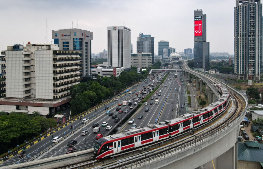
Public Transportation Infrastructure in Modern Jakarta
Jakarta has undergone a structural shift in its public transportation capacity over the past decade. The MRT Jakarta north-south corridor, the LRT Jakarta eastern corridor, the expanded TransJakarta BRT network, and the Commuter Line rail system now collectively serve several million passenger trips daily, representing the most significant expansion of formal transit infrastructure in the city's history.
The KRL Commuter Line connects Jakarta's five major rail terminals — Gambir, Pasar Senen, Manggarai, Tanah Abang, and Jatinegara — to the Bodetabek suburban network, with Manggarai serving as the primary interchange hub following its recent redevelopment as a multimodal terminal. TransJakarta now operates over 200 bus corridors across the metropolitan area, with dedicated bus lanes on major arterials enforced by camera-based monitoring infrastructure.
Waterways, City Forests and Maritime Gateways
Jakarta's canal system — a legacy of Dutch Batavia's water management infrastructure — spans over 1,300 kilometers of waterways across the metropolitan area, though most channels currently function primarily as drainage rather than transport corridors. Pilot waterway transport projects have operated on the Ciliwung and Pesanggrahan rivers, demonstrating the technical feasibility of small-vessel passenger services, though scaling these into a genuine transport network remains a medium-term infrastructure project.
The Cultural Library complex in Cikini and the Jakarta City Library in Menteng serve as multimodal cultural hubs combining archival collections, public programming, and accessible transit connectivity.
Tanjung Priok port complex functions as the nation's primary maritime export-import gateway, handling the majority of containerized trade volume that passes through Indonesian customs. The port's expansion into Kalibaru New Port adds capacity that positions North Jakarta as a sustained logistics anchor for the next two decades.
Jakarta as Indonesia's Primary Office and Corporate Center
Almost all major Indonesian corporate headquarters maintain their primary offices in Jakarta, and the majority of multinational companies operating in Indonesia establish their regional or national headquarters in the Sudirman-Thamrin-Kuningan corridor. This concentration is not incidental — it reflects the alignment of financial regulation, legal jurisdiction, banking infrastructure, and talent supply in a single metropolitan zone.
The reasons Jakarta functions as the dominant office center are structural: the Jakarta Stock Exchange, Bank Indonesia, the Financial Services Authority (OJK), and the major commercial banks all operate from South and Central Jakarta, creating a regulatory and financial ecosystem that makes geographic proximity to the city center a practical business necessity.
Law firms, accounting firms, management consultancies, and technology companies cluster accordingly. Even as Nusantara develops as the new national capital in East Kalimantan, Jakarta's corporate infrastructure shows no structural sign of migration — the city's role as Indonesia's commercial and financial center is expected to persist well past the formal capital transfer.
IKN and the Strategic Redistribution of Indonesia's Capital Power
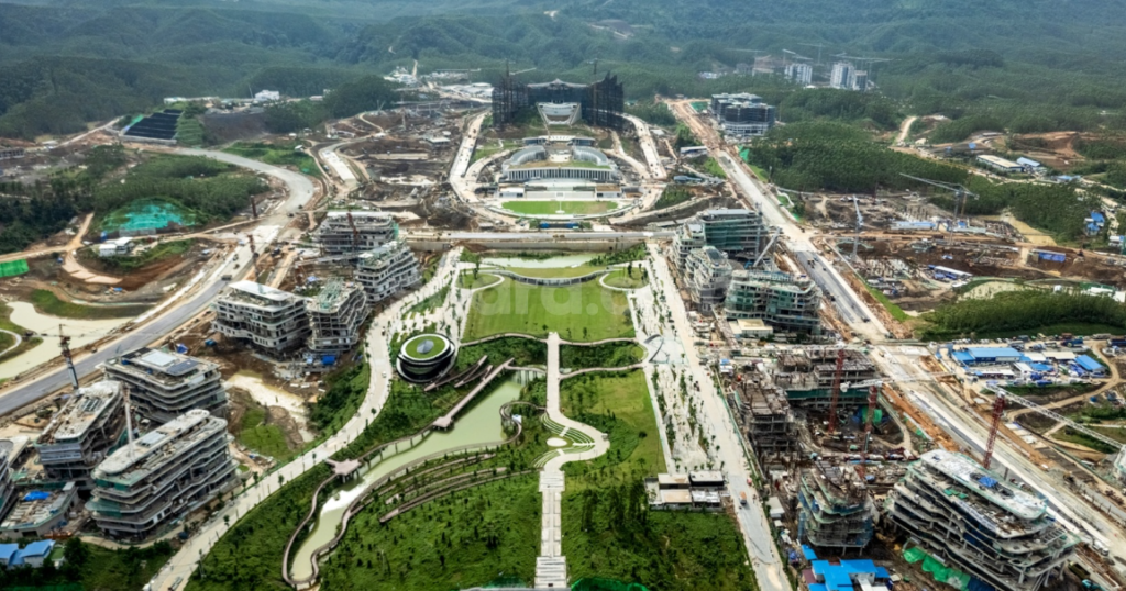
Jakarta's role as national capital is entering its final administrative chapter. The Indonesian government has formally committed to relocating the capital functions to Ibu Kota Nusantara (IKN) in Penajam Paser Utara, East Kalimantan — a project initiated under Presidential Regulation No. 63 of 2022 and backed by the IKN Authority Law that restructures the governance framework for the new capital zone. The relocation timeline targets a phased transfer of presidential and legislative functions, with the first symbolic ceremonies already conducted on the new site.
The primary drivers behind the relocation are structural rather than symbolic. Jakarta sits on a subsiding land mass — portions of North Jakarta have sunk over four meters in the past three decades due to excessive groundwater extraction — while the city simultaneously absorbs the majority of Java's economic pressure within a single administrative zone.
Distributing the capital function to a geographically central location in Kalimantan is framed as both an environmental necessity and a long-term equity intervention, redirecting infrastructure investment away from the Java-centric development model that has dominated since independence.
What the IKN transfer does not resolve is Jakarta's corporate and financial primacy. The IKN Authority governs the new capital's physical development but holds no mechanism to compel corporate migration. Bank Indonesia, the OJK, the Jakarta Stock Exchange, and the headquarters of Indonesia's largest conglomerates are anchored to Jakarta by regulatory proximity, talent infrastructure, and decades of institutional inertia.
The realistic outlook places Jakarta in a post-capital configuration similar to how Kuala Lumpur retained economic dominance after Malaysia's administrative functions shifted to Putrajaya — a precedent that suggests the (DKJ) Daerah Khusus Jakarta metropolis will remain the nation's primary economic engine regardless of where the presidential palace is located.