
Lake Toba is the volcanic crown of Southeast Asia in the most literal geological sense. The lake occupies a caldera produced by the largest volcanic eruption of the Quaternary period, an event approximately 74,000 years ago that ejected around 2,800 cubic kilometers of magma in what is classified as a magnitude 8.8 eruption on the Volcanic Explosivity Index. The eruption lasted roughly two weeks and triggered a volcanic winter that reduced average global temperatures by 3 to 5 degrees Celsius for several years.
Parts of India were buried under six meters of ash. The eruption may have compressed the human population to a genetic bottleneck. What remains is a caldera 100 kilometers long, 30 kilometers wide, and up to 505 meters deep, filled with the largest volcanic lake in the world.
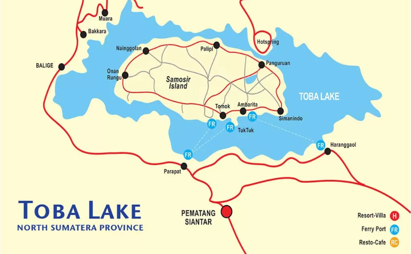
Lake Toba sits at approximately 900 meters above sea level in North Sumatra, Indonesia. Its surface area of 1,707 square kilometers makes it larger than Singapore. At the center of the lake sits Samosir Island, formed through resurgent doming as magma pressure from beneath the caldera floor uplifted a massive block of solidified ignimbrite back toward the surface over tens of thousands of years.
Samosir is one of the largest islands situated within a lake on earth. The caldera walls on the surrounding rim rise 400 to 1,200 meters above the water surface, creating a contained basin that generates its own microclimate and holds the accumulated cultural identity of the Toba Batak people across centuries of unbroken settlement.
Secret Places and Precision Viewpoints Around the Caldera
The standard tourist circuit of Lake Toba concentrates arrivals at Parapat on the eastern shore and channels them across to Tuk Tuk peninsula on Samosir Island. This movement corridor produces predictable crowd concentration at predictable hours. The lake's perimeter contains a distinct tier of viewpoints and natural sites that require additional navigation commitment but produce compositional and experiential results that the Tuk Tuk corridor does not replicate.
Geosite Sipinsur, located in Humbang Hasundutan Regency on the western rim of the caldera, sits at 1,213 meters above sea level and provides a panoramic framing of Lake Toba from an elevation high enough to show the full breadth of the caldera basin and Samosir Island in a single visual field. The site includes a pine forest, an outdoor stage used for Batak cultural performances on Sundays, a foodcourt cluster designed with traditional Batak house ornaments, and open camping grounds.
Temperatures at Sipinsur regularly drop to 17 degrees Celsius, making it functionally cooler than the lakeshore elevation. The regional tourism office of Humbang Hasundutan schedules regular performing arts events at the open stage. Attending requires checking the local government's cultural calendar rather than relying on national tourism platforms.
Tipang Tourism Village in Bakti Raja District, Humbang Hasundutan Regency, represents the hidden valley category of discovery in the Lake Toba circuit. The village sits within a terraced agricultural landscape overlooking the lake from the northern caldera rim. Its rice fields are cited as among the most visually structured in the Lake Toba area, organized across multiple levels with the lake visible behind the lower terraces.
Tipang has been documented in anthropolinguistic research as a community with intact local wisdom practices including traditional irrigation systems tied to ritual and ceremony. The village's agricultural calendar intersects with customary practice at multiple points in the year, and community ceremonies are not staged for tourism but occur within functional seasonal and kinship frameworks.
Situmurun Waterfall: Binangalom
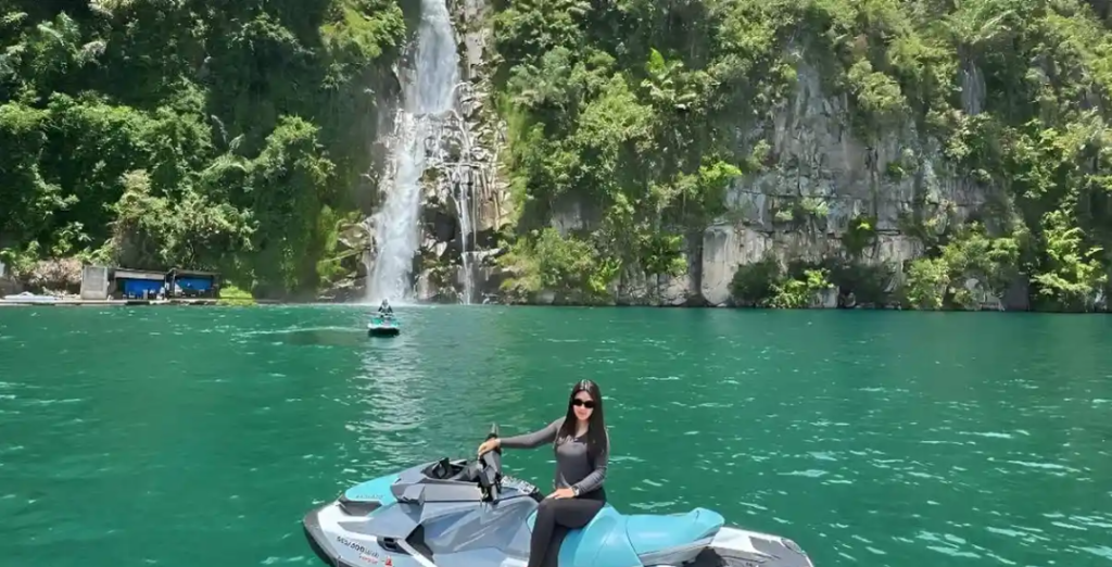
Situmurun Waterfall, also known by its river-sourced name Binangalom, is located in Situmurun Village, Lumban Julu District, Toba Regency, approximately 70 kilometers from Balige and one hour by motorboat from the harbor at Parapat. The waterfall descends 70 meters across seven tiered levels before emptying directly into Lake Toba.
This direct terminus into the lake rather than into a river or pool makes Situmurun structurally distinct from most waterfall sites in North Sumatra. The name Binangalom derives from two Batak Toba words: Binanga, meaning river, and Lom, meaning cooling or refreshing. The combined meaning encodes the experiential quality of the water rather than merely its geographic location.
Access to Situmurun is exclusively by boat. Rental boats depart from Tigaraja Harbor and Ajibata Harbor in Parapat. Private speedboats are available for charter and reduce transit time compared to shared vessels. The journey to Situmurun presents continuous views of the eastern caldera wall and the open water surface of the lake.
Swimming is practiced at the base of the falls, but proximity to the direct fall zone is dangerous due to strong downward current. The volume of visitor traffic at Situmurun remains low relative to Samosir Island sites because the boat-only access eliminates spontaneous walk-in visitors. Morning arrivals between 9:00 and 10:00 AM capture optimal light conditions with the caldera rim illuminated from the east.
Customs and Social Structure of the Toba Batak
The Toba Batak people are organized around a patrilineal clan system in which marga, the family clan name, functions as the primary identifier of kinship, territorial rights, and social obligation. Clan membership determines marriage eligibility, the appropriate posture toward other clan members at adat ceremonies, and the inheritance of land and cultural responsibility. Intermarriage between members of the same marga is prohibited. This exogamy rule is the operational mechanism through which alliances between clan networks are constantly renewed through marriage.
The central philosophical framework governing Toba Batak social interaction is Dalihan Na Tolu, meaning "the three-legged cooking stove." The metaphor refers to a traditional cooking arrangement in which three stones of equal size and equal height support a cooking vessel above a fire. If any of the three stones is missing or unequal, the vessel tips.
The social logic is identical: three relational positions in constant dynamic balance. These three positions are Hula-hula, meaning the wife-giving family to whom respect is owed; Dongan Sabutuha, meaning clan brothers of the same marga from whom solidarity is expected; and Boru, meaning the wife-receiving family who owe service and support to those above them in the kinship chain.
The position each person occupies in Dalihan Na Tolu is not fixed. It rotates depending on the adat context. A man who is Boru in his sister's wedding becomes Dongan Sabutuha at his clan brother's ceremony and Hula-hula at his daughter's wedding. The system produces a social architecture in which every individual has experienced all three positions and therefore understands the obligations of each.
The three behavioral principles that correspond to these positions are Somba marhula-hula, meaning respect toward wife-givers; Elek marboru, meaning affection toward wife-receivers; and Manat mardongan tubu, meaning caution and care in relations with fellow clan members. These principles are not aspirational. They are operationally enforced through adat ceremony, public deliberation, and social accountability within the community network.
The Sanctity of the Tambak Tomb
The tambak is a Toba Batak stone tomb structure, traditionally built to house the bones of significant ancestors following a ceremonial reburial process called mangongkal holi. The mangongkal holi ceremony involves exhuming the remains of a deceased ancestor, usually several generations after the original burial, and reinterring them in a purpose-built stone mausoleum of increasing scale and architectural elaboration.
The scale of the tambak reflects the social prominence and descendant network of the ancestor being honored. The largest tambak structures in the Lake Toba region are multi-tiered stone buildings that resemble miniature architectural monuments visible from the road.
The ceremony surrounding tambak construction is one of the most resource-intensive events in the Toba Batak adat calendar. It requires the coordination of the entire Dalihan Na Tolu network, the provision of ulos cloth, the slaughter of livestock, feasting across multiple days, and the presence of representatives from all branches of the ancestor's clan network. The tambak ceremony is not held on a fixed calendar date.
It is held when the descendant community has assembled sufficient resources and consensus. Visitors who observe tambak structures in villages along the lakeshore road are looking at active memorial infrastructure rather than historical ruins.
Traditional Arts: Expression and Identity
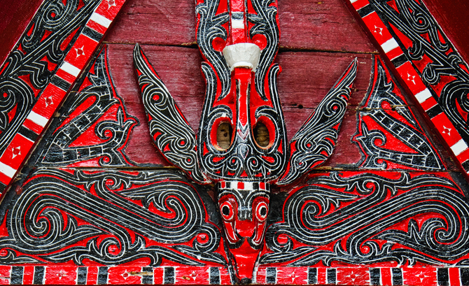
The art of ulos weaving is the primary textile tradition of the Toba Batak and functions simultaneously as craft, ceremonial object, and encoded cultural text. Hutaraja in Samosir Island is one of the most documented ulos weaving centers in the Lake Toba region. Each ulos pattern type carries a specific meaning tied to ceremony and relational status. The Ulos Ragihotang is given from parents to children as a blessing.
The Ulos Sibolang is associated with mourning and is draped over the bereaved. The Ulos Mangiring accompanies the birth of a first child. These are not decorative classifications. They are functional ceremonial designations that determine when and by whom each cloth may be presented.
Ulos is woven on back-strap looms using cotton thread and increasingly synthetic yarn, with natural dye processes present in traditional workshops but largely replaced by chemical dyes in commercial production. Women weavers carry the primary continuity of this tradition. Research published in cultural studies literature identifies women weavers in the Toba area as the central mechanism through which ulos cultural knowledge and artifact production is maintained.
The commercialization of ulos for tourist markets has created a dual production system in which quickly-made souvenir cloths coexist with ceremonially-appropriate pieces that take weeks to complete and are not sold through tourist shops.
Alternative Routes and Logistics Strategy
The primary air access to Lake Toba is through Silangit International Airport, carrying IATA code DTB, located in Siborong-borong, Tapanuli Utara. The airport serves direct flights from Jakarta, Batam, and Medan. From Silangit, the drive to Parapat on the eastern lakeside takes approximately 2 hours.
Drive from Medan's Kualanamu International Airport to Parapat by land takes approximately 4 hours via the Trans-Sumatra Highway. The Trans-Sumatra route is the highest vehicle volume corridor and experiences predictable congestion near Pematang Siantar and at the descent into Parapat.
The outer ring road around Samosir Island is the primary land navigation route for travelers who have crossed to Samosir by ferry and intend to explore the island perimeter. The full ring road circuit covers approximately 120 kilometers. Road quality is variable, with sealed sections alternating with unpaved or poorly maintained segments particularly on the northern and western portions of the island.
Completing the full ring road circuit by motorcycle takes approximately five to six hours without stops. The western shore of Samosir is the least commercially developed section and carries the most intact traditional village landscape along the route.
The Muara to Sibandang ferry crossing provides an alternative logistics connection between the northern shore of Lake Toba in Tapanuli Utara and Sibandang Island, which sits northwest of Samosir in the lake. Muara is a small market town on the northern lakeside road.
The ferry operates on limited daily departures and carries passengers and light vehicles. Sibandang Island is predominantly agricultural, known for its mango production, and is largely absent from packaged tourism itineraries. The crossing is used primarily by local residents and provides access to a part of the lake's community geography that the Parapat-Tuk Tuk main route does not connect.
Cultural Note: Greeting with Horas
When entering a traditional village area in the Lake Toba region, greeting residents with the word "Horas" is both the appropriate form of acknowledgment and the correct social signal that a visitor recognizes the community's cultural framework. Horas functions as a salutation of health, strength, and goodwill.
It is the most widely recognized verbal marker of cultural respect in Toba Batak social interaction and is used at ceremonies, at community gatherings, and in formal adat proceedings. Using it as an entry greeting in a village context signals awareness of local identity rather than treating the settlement as a generic tourist backdrop.
Physical conduct in traditional village areas follows protocols that parallel the social logic of Dalihan Na Tolu. Entering any compound or structure requires acknowledgment before crossing thresholds. Adat ceremonies in progress are not observation opportunities for uninvited visitors.
The tambak sites and traditional bolon houses visible along village roads carry active ceremonial significance that is not suspended because a visitor is present. The appropriate posture is to stop, observe from a distance, and request permission through any available local contact before approaching.
The dress standards expected in traditional contexts across the Lake Toba region reflect the conservative social norms of a community that is majority Protestant Christian with strong adat overlay. This means modest dress covering shoulders and knees is the baseline expectation in any ceremonial or village setting, regardless of the outdoor temperature.
Ulos cloth available for purchase in the market towns around the lake can also function as a ceremonial wrap that signals cultural engagement if worn correctly when attending community events. Local market sellers can advise on appropriate wrapping methods upon request.