
Jambi City occupies the central Sumatran lowland along the banks of the Batanghari River, the longest river in Sumatra, at approximately 1°36' South latitude and 103°36' East longitude. As the capital of Jambi Province, Jambi City functions as the administrative, commercial, and cultural center for a province whose economy is anchored by plantation commodities, petroleum extraction, and river-based logistics. The city's position along the Batanghari corridor has defined its identity since the era of the Jambi Malay Kingdom, when the river served as the primary artery for trade connecting the Sumatran interior to the Malacca Strait and the broader maritime trade network of the Indian Ocean world.
Batanghari River Basin, Low Terrain, and Jambi City's Administrative Grid
The topography of this City is predominantly flat alluvial lowland formed by Batanghari River sediment deposition across millennia of fluvial activity. Elevations within the city boundary range between 5 and 60 meters above sea level, with the lowest zones concentrated along the river margins where periodic flooding during peak wet season discharge affects residential and commercial areas.
The flat terrain has facilitated urban expansion in all directions from the original riverside settlement core, producing a city with a relatively dispersed spatial structure compared to coastal capitals constrained by water or hill topography.
Jambi City is administratively divided into 11 districts (kecamatan) and 62 urban villages (kelurahan), covering a total land area of approximately 205.38 square kilometers. The districts of Pasar Jambi and Pelayangan on the northern riverside anchor the oldest commercial and cultural zones, while Kota Baru to the south hosts the newer government administrative center and expanding residential developments.
Telanaipura district accommodates the university cluster including Universitas Jambi, generating consistent education-driven economic activity in the city's southern quadrant.
The Batanghari River itself functions as both the city's geographic spine and its primary logistics artery, with river transport remaining economically significant for bulk commodity movement despite road infrastructure expansion.
The river's width and navigability through this City allow barge traffic carrying coal, palm oil, rubber, and construction materials to operate continuously alongside the urban waterfront.
Jambi Malay Kingdom, Temboro Fort, and the Road to Autonomous City Status
The political history of this City traces to the Jambi Malay Kingdom, a Malay polity that controlled the Batanghari River trade corridor from at least the 7th century onward. The kingdom's strategic position on the river gave it leverage over the flow of forest products — benzoin, camphor, gold, and rattan from the Sumatran interior to coastal traders accessing the Malacca Strait routes.
Chinese Song dynasty records document tribute relationships with the Jambi polity, confirming its integration into the broader maritime trade system connecting Sumatra to East Asia centuries before European contact.
The Dutch colonial presence formalized through the construction of Fort Temboro on the Jambi riverbank as a defensive and commercial control installation. The fort enabled the VOC and later the Dutch colonial administration to regulate river trade, extract revenue from commodity flows, and project military authority over the Batanghari hinterland.
The fort's location on the northern bank established the settlement pattern that shaped Jambi's subsequent urban development, concentrating government and commercial functions along the river margin.
Jambi City achieved autonomous municipality status through the administrative reorganization that progressively separated Indonesian urban areas from their surrounding regency territories during the New Order and reformasi periods.
The autonomous city designation provided city with independent budget authority, dedicated municipal government institutions, and the administrative tools necessary to manage urban infrastructure development at the pace required by a growing provincial capital population.
How Colonial and Independence-Era Politics Shaped Jambi City's Urban Form
The physical layout of this City reflects successive layers of planning intervention from the Dutch colonial period, the Japanese occupation, and the Indonesian national development era. The colonial riverside commercial district established the city's original commercial axis along the northern Batanghari bank.
Independence-era planning extended the administrative center southward, separating government functions from the older commercial zone and producing the dual-center urban structure that characterizes Jambi today.
The New Order transmigration and plantation development program transformed Jambi Province's economy and demographic composition in ways that amplified the city's role as the administrative and commercial processing hub for an expanding plantation economy.
The growth of palm oil and rubber production across Jambi's regencies through the 1980s and 1990s generated commodity flows that required the financial services, logistics infrastructure, and regulatory oversight concentrated in the City, driving sustained urban economic expansion alongside the plantation frontier.
Majority Ethnic Groups, Jambi Malay Culture, and the City's Social Character
The Jambi Malay community constitutes the largest ethnic group in this City, with cultural roots extending to the Malay kingdoms that controlled the Batanghari corridor across more than a millennium of recorded history. Jambi Malay identity is organized around adat (customary law) frameworks that govern land relationships, community obligations, and ceremonial life.
Adat structure remains active in both rural communities and urban neighborhoods, shaping how customary disputes are negotiated and how community solidarity is expressed alongside formal legal and government institutions.
Alongside the Jambi Malay majority, the city hosts Javanese, Minangkabau, Batak, Bugis, and Chinese-Indonesian communities whose migration histories span the colonial and post-independence periods. The Minangkabau community is particularly significant in commercial networks, consistent with the broader pattern of Minangkabau merchant migration across Sumatra.
Chinese-Indonesian community concentrated in the Pasar Jambi commercial district, has maintained trading networks in the city since the colonial period and continues to anchor wholesale and retail commerce in the riverside market zone.
Jambi Malay Dialect, Regional Languages, and the "Idak" Slang Identity
Jambi Malay is a variety of Malay that occupies a distinct position within the Malay dialect continuum of Sumatra, sharing features with both Palembang Malay to the south and Riau Malay to the north while maintaining vocabulary and phonological characteristics specific to the Batanghari River cultural zone.
The dialect is characterized by open vowel pronunciation, specific intonation patterns, and a vocabulary that incorporates terms from the forest product trade history and the riverine environment that defined Jambi Malay material culture.
The negation particle "idak," equivalent to "tidak" (not/no) in standard Indonesian, functions as the primary colloquial marker of Jambi Malay speech identity. "Idak tau" (don't know), "idak biso" (can't), and "idak apo-apo" (it's nothing) appear continuously in informal conversation and immediately signal a Jambi speaker to listeners familiar with Sumatran Malay dialect geography.
The "idak" particle has become a cultural identity shorthand for Jambi in national social media discourse, functioning similarly to the "sonde" of Kupang or the "ji" of Makassar as a locally specific speech marker with broad recognition.

Gentala Arasy Bridge Crosses the River and Anchors the City's Civic Identity
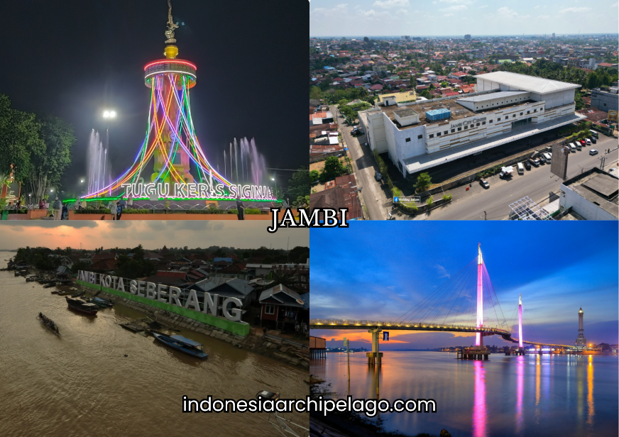
Gentala Arasy Bridge, completed in 2014, spans the Batanghari River connecting the northern Pasar Jambi district to the southern Danau Teluk area, incorporating a pedestrian bridge with an Islamic-themed decorative tower that functions simultaneously as a transport crossing and a civic landmark.
The bridge name references Islamic cosmology, and the tower design incorporates crescent and geometric motifs that reflect Jambi's Malay Muslim cultural identity. At night, the bridge's lighting installation transforms it into the most visually prominent feature of the City waterfront.
The bridge's completion improved connectivity between the northern commercial district and the southern residential communities that had historically been separated by the river's width. It has become the primary photography and recreation destination along the Jambi waterfront, activated by evening food stalls, pedestrian promenaders, and visitors drawn by the tower's distinctive silhouette.
Gentala Arasy structure is the defining image of contemporary Jambi City in tourism and media representations.
Water Clock Tower Stands as Jambi City's Heritage Landmark on the Bank
The Water Clock Tower (Menara Jam Air) on the city riverfront is one of the surviving heritage structures from the colonial administrative period, constructed as a functional timekeeping installation that served the commercial and administrative population of the riverside settlement. The tower's mechanical clock mechanism and its riverfront position made it a reference point for the river traffic schedule coordination that was essential to commerce in a city organized around barge and boat transport.
The tower has been preserved as a heritage landmark and sits within the riverfront public space that the municipal government has developed as a pedestrian and recreation zone.
Its scale and colonial architectural character contrast with the surrounding contemporary commercial and residential development, functioning as a physical reminder of the colonial infrastructure layer embedded in the City's urban fabric.
Across the City, Lake Sipin, and the Cultural Heritage Tourism Corridor
Seberang Kota (Across the City) refers to the traditional Jambi Malay settlements on the southern bank of the Batanghari River, directly opposite the main commercial district. These settlements, accessible by small ferry boats that have operated the crossing for generations, maintain traditional Malay house architecture, weaving workshops, and cultural practices at a density not found in the northern urban core.
The Seberang Kota area is the primary destination for cultural heritage tourism in Jambi City, attracting visitors interested in traditional Malay material culture, river community lifestyle, and the handicraft production that continues in the neighborhood workshops.
Lake Sipin, located within the city boundary in the Telanaipura district, is an oxbow lake formed by a former meander of the Batanghari River that was cut off from the main channel by natural hydrological processes.
The lake provides a freshwater recreational environment with boat rental, fishing, and waterside food stall facilities that serve the urban population seeking lakeside leisure within the city.
The surrounding green space and the lake's visual separation from the urban commercial environment give it a recreational character that complements the river-focused cultural tourism of the Seberang Kota zone.
Shopping Centers, Integrated Retail Hubs, and the Urban Leisure Economy
Jambi City's retail landscape is anchored by Mall WTC Batanghari and Jambi Town Square, supplemented by traditional markets including Pasar Angso Duo and the city central market that handle fresh produce, dry goods, and commodity trading serving both urban residents and traders from the surrounding plantation regencies.
The combination of modern mall retail and traditional commodity market infrastructure reflects Jambi's dual commercial function as both a consumer city for its resident population and a commodity trading hub for the plantation economy of the provincial hinterland.
The integrated retail hub development pattern in the City follows the trajectory of other mid-size Indonesian provincial capitals where mall construction has driven residential development in adjacent zones and reshaped urban mobility patterns around private vehicle access to retail anchor destinations.
Food and beverage, fashion, electronics, and entertainment retail concentrated in mall formats serve the middle-income government and plantation sector employee population that constitutes the primary consumer market.
Jambi Batik Sanggat Ship Motif and Rattan Craft as the Creative Exports
Jambi batik is distinguished within the Indonesian batik tradition by its characteristic color palette dominated by deep reds, earthy browns, and gold on dark backgrounds and by its repertoire of motifs derived from Jambi Malay court culture and natural environment.
The Sanggat ship motif (kapal sanggat) depicts the traditional Batanghari River vessel that was central to Jambi Malay trade and ceremonial culture, referencing the river commerce identity that defined the kingdom's historical significance.
Jambi batik production is concentrated in workshops in the Seberang Kota area and in dedicated craft villages in the surrounding regency, with finished products distributed through the City's craft retail network and national batik trade channels.
Rattan craft production draws on Jambi Province's forest rattan resource base, which has historically supplied both domestic craft production and export raw material. Artisan workshops in and around the City produce rattan furniture, baskets, mats, and decorative objects using weaving and construction techniques adapted to the specific rattan species available from the Sumatran forest zone.
Provincial government craft promotion programs have worked to develop design innovation and quality standardization within the rattan craft sector to improve competitiveness in domestic and international furniture and home accessories markets.
Natural Rubber, Palm Oil, and Areca Nut Define the Export Commodity Base
Natural rubber from smallholder and estate plantations across Jambi Province constitutes the most significant volume commodity flowing through the City's trade and logistics infrastructure. Jambi Province is consistently among the top rubber-producing provinces in Indonesia, and the commodity moves through processing facilities, grading centers, and export logistics chains with Jambi City as the administrative and financial hub.
Rubber price fluctuations in global commodity markets directly affect the income of Jambi Province's large smallholder farming population and the commercial activity of the city's trading and financial sector.
Palm oil from the rapidly expanded plantation zones across Jambi's regencies feeds into processing mills and refinery facilities whose output moves toward Jambi City's logistics network for domestic distribution and export.
Areca nut (pinang), used in betel nut preparations consumed across South and Southeast Asia, is a significant smallholder agricultural commodity in Jambi Province with export flows to India, Bangladesh, and other Asian markets.
The areca nut trade moves through Jambi City's commodity trading networks and contributes to the agricultural export volume processed through Talang Duku River Port.

Tempoyak, Nasi Minyak, and Pempek Jambi on Every Table in the City
Tempoyak is a fermented durian preparation unique to the Malay culinary tradition of the Batanghari River zone, produced by fermenting fresh durian flesh with salt over several days until it develops a pungent, sour flavor profile distinct from fresh durian.
It is used as a cooking ingredient in fish dishes — most characteristically in tempoyak ikan patin, where the fermented durian sauce is cooked with freshwater catfish (patin) from the Batanghari River and as a condiment served alongside rice.
The dish represents the most distinctive and locally specific element of Jambi's culinary identity, connecting the city's food culture directly to its river and forest resource environment.
Nasi minyak is a Jambi Malay ceremonial rice preparation cooked with ghee, whole spices including cinnamon, cardamom, and cloves, and served at weddings, circumcisions, and community celebrations. The dish reflects the Middle Eastern culinary influence embedded in Malay court culture through centuries of Arab trade contact along the Malacca Strait route.
Pempek Jambi is the local variant of the Palembang fish cake tradition, produced with freshwater fish from the Batanghari rather than the marine fish used in coastal Palembang production, resulting in a flavor profile that reflects the river environment that distinguishes Jambi's culinary tradition from its southern neighbor.
Corporate Landscape, Financial Sector, and the Warehousing Zone Network
The corporate presence in Jambi City is structured around the commodity trading, plantation services, and logistics functions that serve Jambi Province's plantation economy. Palm oil trading companies, rubber grading and export firms, agricultural input suppliers, and plantation management services companies maintain Jambi City offices as their provincial operational base.
Energy sector companies with concessions in Jambi's petroleum and coal production zones also contribute to the city's corporate landscape through regulatory liaison and logistics coordination offices. The financial sector includes Bank Jambi, the provincial development bank, alongside regional offices of national state banks and private commercial lenders.
Commodity financing, particularly pre-harvest credit for rubber and palm oil smallholders and inventory financing for commodity traders constitutes a significant component of the banking sector's lending portfolio in Jambi, reflecting the plantation economy's credit demand cycle.
Warehousing zones concentrated in the Talang Duku port corridor and the eastern industrial periphery of the city provide storage infrastructure for rubber bales, palm oil, areca nut, and manufactured consumer goods moving through the city's logistics network.
River Maritime Cluster, Sand Barge Shipyards, and the Talang Duku Port Axis
The Batanghari River maritime cluster encompasses traditional shipbuilding yards, barge repair facilities, fuel depots, and the river transport operator businesses that manage the commodity barge fleet moving coal, palm oil, rubber, and construction sand through Jambi City toward downstream export terminals.
Sand barge construction and repair is a specialized marine industry in the Jambi river zone, producing the flat-bottomed vessels optimized for Batanghari River navigation conditions that constitute the primary bulk commodity transport infrastructure for the province's interior production zones.
Talang Duku River Port, located approximately 26 kilometers downstream from central Jambi City, serves as the primary port facility for ocean-going vessels accessing the Batanghari River from the Berhala Strait. The port handles container cargo, bulk commodities, and inter-island shipping connections that integrate Jambi into the national maritime logistics network.
The river approach to Talang Duku requires dredging maintenance to sustain navigable depths for the vessel sizes that the port's commercial operations require, making river channel management a continuous infrastructure investment priority.
Sultan Thaha Airport, Jalintim Highway, and the Trans-Sumatra Toll Integration
Sultan Thaha Airport, located approximately 6 kilometers from the Jambi City center, serves domestic routes to Jakarta, Batam, Palembang, and several regional Sumatran destinations. The airport's proximity to the city center provides convenient access but constrains runway length and expansion options as urban development has surrounded the facility.
Capacity and route network limitations have been addressed through terminal infrastructure upgrades, and discussions of long-term airport relocation to a site with more expansion capacity have entered provincial infrastructure planning frameworks.
The East Sumatra Trans-Sumatra Highway (Jalintim) passes through Jambi City as a primary land transport artery connecting the city to Palembang in the south and Pekanbaru in the north, constituting the backbone of Sumatra's eastern lowland road logistics network.
The Jalintim route carries the dominant share of inter-city truck freight across eastern Sumatra, connecting plantation commodity production zones to processing facilities and port terminals distributed along the Sumatran corridor.
The Trans-Sumatra Toll Road integration project, progressively extending toll road sections across the Sumatran length, includes the Jambi corridor within its long-term network plan. Completed toll road sections connecting Jambi to Palembang have reduced travel times and logistics costs on the southern corridor, and northward extension toward Pekanbaru and the Riau Province industrial and port zone remains in active development.
Full Trans-Sumatra toll road integration will position Jambi City within a continuous high-speed overland logistics network linking it to the Sumatran port infrastructure of Belawan, Batam, Panjang, and Teluk Bayur that serves the province's export commodity flows.